Kitselas, British Columbia

Last updated

Kitselas
railway point
Canada British Columbia location map 2.svg
Red pog.svg
Location of Kitselas in British Columbia
Coordinates: 54°33′59″N128°27′05″W / 54.56639°N 128.45139°W / 54.56639; -128.45139
CountryCanada
Province British Columbia
Region Skeena
Regional district Kitimat–Stikine
Time zone UTC-8 (PST)
  Summer (DST) UTC-7 (PDT)
Area codes 250, 778, 236, & 672
Waterways Skeena River

Kitselas is a railway point on the northwestern shore of the Skeena River in the Skeena region of west central British Columbia, Canada. [1] The former name was Vanarsdol. Across the Skeena to the southwest is the mouth of the Zymoetz River (commonly called the Copper River). This river bridge on BC Highway 16 is by road about 10 kilometres (6 mi) northeast of Terrace.

Contents

Railway

The Grand Trunk Pacific Railway (GTP) surveyors considered two routes between present day Telkwa and this vicinity. One was via the Telkwa and Zymoetz rivers and the other was via the Bulkley River and Hazelton. Although the former was 129 kilometres (80 mi) shorter, the BC government influenced the decision to select the latter. [2]

In early November 1910, the eastward advance of the GTP rail head from Prince Rupert passed through mile 100 (Vanarsdol), [3] reaching Newtown [4] at mile 102 (western end of the tunnels), [5] where it halted for over a year. After Foley, Welch and Stewart (FW&S), the GTP prime contractor, handed over control of the line west of Vanarsdol to the GTP (which commenced scheduled service in June 1911), [6] the construction work east of that point was regarded as the ongoing extension. [7] In mid-January 1912, the FW&S Newtown temporary terminal ceased to exist when tracklaying proceeded through the tunnels. [8]

Vanarsdol station was named after Cassius Cash Van Arsdol, GTP chief engineer. [9] His directive to the route surveyors, especially for the Canadian Rockies segment, was to ensure the grade did not to exceed four-tenths of one percent. Consequently, his nickname thereafter was "Four-tenths Van". [10]

By 1911, the Copper River siding existed. [11] The planned station locations in the vicinity had been Kitsum, Copper River, and Kitselas. [12] Stations quickly eventuated at Littleton (Terrace) (but not Kitsum just to the west) and at Vanarsdol (rather than opposite old Kitselas (Kitselas Canyon), but not for the Copper River siding at Stewart's Landing. [13] Later that decade, the latter opened as the Dobies station.

In the 1936 flood, the Canadian National Railway (CN) pumphouse stopped working and the foundations of the railway depot and water tower were so badly undercut, that the structures were overhanging the river. [14]

Train Timetables (Regular stop or Flag stop)
Mile19141920192519321935194319501956196019651970197419751980198519881989
[15] [16] [17] [18] [19] [20] [15] [21] [22] [23] [24] [25] [26] [27] [28] [29] [30] [31]
Terrace1663.3Reg.Reg.Reg.Reg.Reg.Reg.Reg.Reg.Reg.Reg.Reg.Reg.Reg.Reg.Reg.Reg.Reg.
Dobies1659.0Flag a FlagFlagFlagFlagFlag
Vanarsdol1657.7FlagFlagFlagFlagReg.
Kitselas1657.7FlagFlagFlagFlagFlagFlagFlag
Mileage 125.71657.2FlagFlagFlagFlag
Usk1650.7FlagFlagReg.Reg.Reg.BothReg.Reg.Reg.FlagFlagFlagFlagFlagFlagFlagFlag
Royal Lumber1646.4Flag
Pitman1644.0FlagFlagFlagFlagFlagFlagFlagFlagFlagFlagFlagFlagFlagFlag
Pacific1638.5Reg.Reg.Reg.Reg.Reg.Reg.Reg.Reg.FlagFlagFlagFlagFlagFlagFlagFlagFlag

^a . A flag stop from at least 1918, which continued throughout the 1920s. [32]

Newtown

Newtown referred to the temporary railway terminal vicinity on the west shore. [33] This more significant construction camp is best regarded as a general area rather than a specific place. In 1911, Frank Bowness opened a restaurant and bunkhouse, [34] which unlikely survived much beyond that year.

The earlier use of Newtown to designate a First Nation reserve [35] could refer to either the Kitselas 1 [36] or Kshish 4 [37] or both.

Kitselas (formerly Vanarsdol)

This location on the northwest side of the Skeena is surrounded by the Kitselas Kshish First Nation Reserve 4. The First Nations school, which existed 1904–1959 [38] at Vanarsdol, [39] was initially administered by the Methodist mission. [40] Fire destroyed the schoolhouse in 1933 [41] and its vacant replacement in 2010. [42]

The earliest newspaper mention of the Vanarsdol place name is June 1911. [6] The post office existed 1913–1927. [43]

About 1924, William Hagan opened the Vanarsdol Lumber Co and his wife Wilhelmina opened a general store, which contained the post office. [9] In 1927, fire destroyed the Hagan sawmill, adjacent buildings, and 180,000 metres (600,000 ft) of lumber. [44] A mention of the mill site as Copper City in 1928 is likely a reference to the general area. [45]

In 1931, the rebuilt mill diversified into box making. [46] Strawberry crops also thrived. [47] The sawmill operated at least until the mid-1930s. [48]

Dobies

This location was on the northwest side of the Skeena, downstream from the Zymoetz River. In the 1890s, pioneer settlers John (David) Stuart and family arrived. On their homestead, they developed an exceptional orchard. [49] Steamboats called at Stuart Landing for cordwood fuel. Simeon Wilson Dobbie came in 1898 and married Jemima Stuart in 1905. The Dobbies purchased part of the Stuart property in 1908, and the wharf became Dobbie Landing. [50] Ferries, a railway flag stop, and a school have existed in the vicinity.

Copper City

In 1908, William John Sanders, prospector and Sergeant-at-arms in the BC Legislature, chose the name of Copper City for the new townsite, which would occupy 118 hectares (292 acres) of his 523-hectare (1,292-acre) property immediately south of the Zymoetz River mouth. [51] In 1909, a Prince Rupert syndicate paid $45,000 for over 40 hectares (100 acres) of the site for immediate marketing. [52]

In 1907, Harry Creech opened a hotel. [53] He was the inaugural Copper River postmaster 1909–1914 [54] and also ran a general store. [12] In 1909, a second general store opened, [55] which Percy Ralph Skinner and his brother ran [12] as a HBC agency. [56]

In 1910, W.J. Sanders built a hotel. [57] By 1913, no hotels operated. [58] In 1915, the school opened. [59] [60] In 1929, a new schoolhouse was erected. The former one had been a small frame building with broken windows and no toilets. [61] The one-room school stood in the Dobies area on the northwest side of the Skeena. [62]

In the early 1930s, the only outside road link was with Terrace. [63]

Eastward View of Copperside Estates, 2011. Copper Estates, Terrace.jpg
Eastward View of Copperside Estates, 2011.

In 1950, the school closed. [64] The post office closed in 1956, [54] and the Skinner family store existed at least until this time. [65]

Copperside Estates

About 1971, the Copperside Estates subdivision opened [66] immediately north of the Zymoetz River mouth.

In 1994, the Copperside Stables were established. [67]

In 2019, a hydraulic hose failed on a BC Hydro truck, resulting in a 10-to-15-litre (2.2 to 3.3 imp gal; 2.6 to 4.0 US gal) spill of hydraulic fluid in the area. The private Copper Estates water system provider advised the almost 400 residents to avoid using their water for about a week because the spill occurred close to a well. [68] Boil water advisories prompted residents in 2021 to request the regional district take over the water supply system. [69]

The current passenger transit provider is BC Transit. [70]

Ferries

Stewart Ferry across the Skeena

Stuart Landing (alternative spelling Stewart) was also a ferry location. Existing from the 1890s, Stewart's Ferry was different from the Copper River mouth locale, which suggests a positioning distinctly to the southwest. [71] This ferry operated into the earlier years of the following century. [72]

Copper City Ferry across the Skeena

In 1908, a subsidized [73] two-year ferry charter covering 3.2 kilometres (2 mi) up and downstream was tendered. [74] No evidence exists that any such service began. W.J. Saunders installed and commenced a reaction ferry in 1910. [75] [76] However, residents would have preferred the government operate the service. [77]

The new 4.5-tonne; 4.5-long-ton (5-short-ton) ferry installed in 1923–24 was operated by residents rather than a government employee. [78] The northwest ferry dock was in the general vicinity of Dobies station. [79]

In 1933, an automobile overran the far end of the ferry while loading, and the three passengers inside drowned. [80] In 1934, a new ferry operator residence was built. [12] In 1938–39, two new landing pontoons were constructed. [81]

During flooding in 1945, the ferry lost its northern landing pontoon. [82] In 1947–48, a new 9.1-tonne; 8.9-long-ton (10-short-ton) ferry with steel pontoons was installed. [83]

In 1950, spring floods damaged the ferry. [84] During winters, a rowboat was employed. [85] When the ice thickness was sufficient, an ice crossing served pedestrians. [86]

Around 1969, the ferry was discontinued, [87] which ended road access to Kitselas.

Lower Copper River Ferry

By the 1920s, a cable crossing existed 5 to 6 kilometres (3 to 4 mi) from the river mouth. [88] It is unclear if the basket ferry operating at least 1927–1934 was at this or another location. [89]

About 3 kilometres (2 mi) from the mouth, a one-lane bridge dating from the early 1910s [90] was replaced in 1929. [88]

Upper Copper River Ferry

About 45 kilometres (28 mi) from the mouth, an aerial passenger ferry existed in 1914, [91] which was upgraded to a ferry in 1921. [88] [92]

Maps

Footnotes

  1. "Kitselas (railway point)". BC Geographical Names .
  2. Lower 1939, p. 75 (67).
  3. "Prince Rupert Optimist". library.ubc.ca. 12 Nov 1910. p. 7.
  4. "Omineca Herald". library.ubc.ca. 3 Dec 1910. p. 1.
  5. "Fort George Tribune". pgnewspapers.pgpl.ca. 31 Dec 1910. p. 1.
  6. 1 2 "Gazette". www.newspapers.com. 15 Jun 1911. p. 9.
  7. "Omineca Miner". library.ubc.ca. 2 Dec 1911. p. 1.
  8. "Omineca Herald". library.ubc.ca. 19 Jan 1912. p. 1.
  9. 1 2 3 "Vanarsdol". www.gent.name.
  10. Lower 1939, pp. 141–142 (132–133).
  11. "Prince Rupert Journal". library.ubc.ca. 31 Mar 1911. p. 6.
  12. 1 2 3 4 "Copper City". www.gent.name.
  13. "Omineca Miner". library.ubc.ca. 2 Sep 1911. p. 1.
  14. Septer 2007, p. 33.
  15. 1 2 "Timetable" (PDF). streamlinermemories.info. 28 Apr 1943. p. 62 (TT226).
  16. Timetable. 1 Mar 1914. p. 15 (TT14).
  17. Timetable. 3 Oct 1920. p. 12.
  18. Timetable. Jan 1925. p.106 (TT156)
  19. Timetable. 1932. p.58 (TT226)
  20. Timetable. 1935. p.60 (TT226)
  21. "Timetable". www.scribd.com. 30 Apr 1950. p. 59 (TT226).
  22. "Timetable" (PDF). streamlinermemories.info. 30 Sep 1956. p. 55 (TT138).
  23. "Timetable" (PDF). streamlinermemories.info. 30 Oct 1960. p. 54 (TT139).
  24. "Timetable". pre.timetableworld.com. 25 Apr 1965. p. 41 (TT92A).
  25. "Timetable". pre.timetableworld.com. 7 Jan 1970. p. 29 (TT50).
  26. "Timetable". pre.timetableworld.com. 27 Apr 1974. p. 18 (TT49).
  27. "Timetable". pre.timetableworld.com. 26 Oct 1975. p. 11 (TT16).
  28. "Timetable". pre.timetableworld.com. 3 Feb 1980. p. 41 (TT57).
  29. "Timetable". pre.timetableworld.com. 1 Jun 1985. p. 49 (TT39).
  30. "Timetable". pre.timetableworld.com. 30 Oct 1988. p. 55.
  31. "Timetable". pre.timetableworld.com. 30 Apr 1989. p. 55.
  32. "1918 BC Directory". www.bccd.vpl.ca.
    to "1932 BC Directory". www.bccd.vpl.ca.
  33. "Omineca Herald". library.ubc.ca. 15 Jul 1911. p. 7.
  34. "Daily News (Prince Rupert)". library.ubc.ca. 20 Nov 1911. p. 1.
  35. "Prince Rupert Optimist". library.ubc.ca. 15 Feb 1911. p. 4.
  36. "Kitselas 1 (reserve)". BC Geographical Names .
  37. "Kshish 4 (reserve)". BC Geographical Names .
  38. "List of Federal Indian Day Schools" (PDF). indiandayschools.com. p. 10.
  39. "Omineca Miner". library.ubc.ca. 1 Jan 1916. p. 1.
  40. "1918 BC Directory". www.bccd.vpl.ca.
  41. "Province". www.newspapers.com. 20 Jan 1933. p. 1. …the destruction by fire of the Indian Mission School at Kitselas…
  42. "Terrace Standard". www.newspapers.com. 28 Apr 2010. p. 8. A piece of First Nations history burned to the ground… school was used in the 1930s and 1940s by Kitselas students who lived on the reserve before shutting down in the 1950s when families moved to Terrace…
  43. "Postmasters (Vanarsdol)". www.bac-lac.gc.ca.
  44. "Prince George Citizen". pgnewspapers.pgpl.ca. 7 Jul 1927. p. 1.
  45. "Interior News". www.newspapers.com. 31 Oct 1928. p. 6. Interior mills that have operated throughout the year…Vanarsdol Lumber Co., Copper City.
  46. "Vancouver Sun". www.newspapers.com. 8 May 1931. p. 8. Hagan's mill at Vanarsdol…will make a speciality of box wood for the fish…and fruit business..
  47. "Interior News". www.newspapers.com. 15 Jul 1931. p. 6.
  48. "Terrace News" (PDF). core.ac.uk. 5 Jun 1935. p. 3.
  49. "John "David" Stuart Bio". www.gent.name.
  50. "Stuart and Dobbie's Landing". www.terracelibrary.ca.
  51. "Daily Colonist". archive.org. 23 Apr 1908. p. 7.
  52. "Daily Colonist". archive.org. 25 Apr 1909. p. 3.
  53. "Victoria Daily Times". www.newspapers.com. 6 Nov 1907. p. 2. Harvey Creech…to look after the opening of a hotel which he is starting at Copper River City.
  54. 1 2 "Postmasters (Copper River)". www.bac-lac.gc.ca.
  55. "Calgary Albertan". www.newspapers.com. 22 Nov 1909. p. 2.
  56. "Terrace Standard". www.newspapers.com. 4 May 1994. p. 28.
  57. "Daily Colonist". archive.org. 5 Jul 1910. p. 11.
  58. Minister of Lands annual report, 1913. library.ubc.ca (Report). p. 426 (D361).
  59. Stortz 1988, p. 83 (71).
  60. Public Schools annual report, 1914–15. library.ubc.ca (Report). p. A42.
  61. Stortz 1988, p. 118 (106).
  62. "Terrace Standard". www.newspapers.com. 15 May 1996. p. 17.
    "Terrace Standard". www.newspapers.com. 6 Mar 1996. p. 18. …Copper City – the school was on Dobie's property across the river from Skinner's Corner
  63. "Northern Sentinel". www.newspapers.com. 9 Aug 1957. p. 10. In 1933…the only road…was an 8-mile stretch from Terrace to Copper City and about 20 miles between Lakelse and Kitsumkalum Lakes.
  64. Public Schools annual report, 1949–50. library.ubc.ca (Report). p. O160.
  65. "1955 Prince Rupert Directory". www.bccd.vpl.ca.
  66. "Terrace Herald" (PDF). core.ac.uk. 8 Mar 1971. p. 7.
  67. "Terrace Standard". www.newspapers.com. 27 Apr 1994. p. 8.
  68. "Terrace Standard". www.terracestandard.com. 17 Jan 2020.
  69. "Terrace Standard". www.terracestandard.com. 28 Jan 2021.
  70. "Route 14: Gitaus/Queensway". www.bctransit.com.
  71. Commissioner of Land and Works annual report, 1899. library.ubc.ca (Report). p. 102 (380).
  72. Department of Agriculture annual report, 1902. library.ubc.ca (Report). p. 104 (A91).
  73. Commissioner of Land and Works annual report, 1907–08. library.ubc.ca (Report). p. H35.
  74. "Week". library.ubc.ca. 9 May 1908. p. 6.
  75. Clapp, Frank A. (1991). Ministry of Transportation and Highways, Lake and River Ferries. Ministry of Transportation and Highways. p. 18. ISBN   0-7726-1364-8.
  76. "Prince Rupert Optimist". library.ubc.ca. 27 Jul 1910. p. 2.
    "Prince Rupert Journal". library.ubc.ca. 9 Aug 1910. p. 3.
  77. "Daily Colonist". archive.org. 8 Aug 1911. p. 14.
  78. Minister of Public Works annual report, 1923–24. library.ubc.ca (Report). pp. 7, 37 (L7, L23).
  79. Minister of Mines annual report, 1927. library.ubc.ca (Report). p. 134 (C123).
  80. "Province". www.newspapers.com. 20 Jun 1933. p. 1. …Mildred Clarke, 18; Gerald Clarke, 12; and George Dobbie, 12, all of Copper City, who were drowned in the Skeena River…when an automobile plunged from the government ferry. Harry Clarke…while driving on to the ferry…over-ran the apron…
  81. Minister of Public Works annual report, 1938–39. library.ubc.ca (Report). p. 39 (Z29).
  82. Septer 2007, p. 46.
  83. Minister of Public Works annual report, 1947–48. library.ubc.ca (Report). p. 45 (N29).
  84. Septer 2007, p. 55.
  85. Minister of Highways annual report, 1958–59. library.ubc.ca (Report). p. G61.
    "Minister of Highways annual report, 1961–62". library.ubc.ca. p. J104.
  86. Minister of Highways annual report, 1964–65. library.ubc.ca (Report). p. C106.
    Minister of Highways annual report, 1965–66. library.ubc.ca (Report). p. C106.
  87. Minister of Highways annual report, 1968–69. library.ubc.ca (Report). p. C122.
  88. 1 2 3 "Copper River Bridge". www.gent.name.
  89. Public Accounts annual report, 1927–28. library.ubc.ca (Report). p. 289 (T253).
    to Public Accounts annual report, 1933–34. library.ubc.ca (Report). p. 217 (L185).
  90. Minister of Mines annual report, 1914. library.ubc.ca (Report). p. 126 (K115).
  91. Minister of Mines annual report, 1914. library.ubc.ca (Report). pp. 136–137 (K124–125).
  92. Minister of Mines annual report, 1921. library.ubc.ca (Report). p. 106 (G94).
  93. Minister of Mines annual report, 1914. library.ubc.ca (Report). p. 132.

Related Research Articles

Highway 16 is a highway in British Columbia, Canada. It is an important section of the Yellowhead Highway, a part of the Trans-Canada Highway that runs across Western Canada. The highway closely follows the path of the northern B.C. alignment of the Canadian National Railway (CN). The number "16" was first given to the highway in 1941, and originally, the route that the highway took was more to the north of today's highway, and it was not as long as it is now. Highway 16 originally ran from New Hazelton east to Aleza Lake. In 1947, Highway 16's western end was moved from New Hazelton to the coastal city of Prince Rupert, and in 1953, the highway was re-aligned to end at Prince George. In 1969, further alignment east into Yellowhead Pass was opened to traffic after being constructed up through 1968 and raised to all-weather standards in 1969. Highway 16's alignment on Haida Gwaii was commissioned in 1983 and is connected to the mainland segment via BC Ferries route #11.

<span class="mw-page-title-main">Usk, British Columbia</span> Hamlet in British Columbia, Canada

Usk is an unincorporated community in the Skeena region of west central British Columbia, Canada. The Usk Ferry connects the two parts of the hamlet that straddle the Skeena River. Just off BC Highway 16, the locality is by road about 182 kilometres (113 mi) west of Smithers and 23 kilometres (14 mi) northeast of Terrace.

Walhachin is an unincorporated community in the Thompson Country region of south central British Columbia, Canada. The place is on a south shore bench of the Thompson River between Brassey and Jimmie creeks. The locality, off BC Highway 1, is by road about 77 kilometres (48 mi) northeast of Spences Bridge, 28 kilometres (17 mi) east of Cache Creek, and 66 kilometres (41 mi) west of Kamloops.

Holberg is a former ferry terminal about 35 kilometres (22 mi) from the northwest tip of Vancouver Island, British Columbia. This unincorporated community is at the head of Holberg Inlet, which forms the western arm of Quatsino Sound.

<span class="mw-page-title-main">Kitwanga</span> Place in British Columbia, Canada

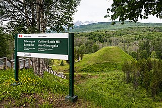
Kitwanga or Gitwangak is in the Skeena region of west central British Columbia. Among the Hazelton and Buckley Mountain Ranges, the place is on the north shore of the Skeena River, east of the Kitwanga River confluence. On BC Highway 37, northeast of the junction with BC Highway 16, the locality is by road about 115 kilometres (71 mi) northwest of Smithers, 99 kilometres (62 mi) northeast of Terrace, and 212 kilometres (132 mi) southeast of Stewart.

Alexandria or Fort Alexandria was a general area encompassing a trading post, ferry site, and steamboat landing in the North Cariboo region of central British Columbia. The present unincorporated community is on the eastern side of the Fraser River. On BC Highway 97, the locality is by road about 74 kilometres (46 mi) northwest of Williams Lake and 45 kilometres (28 mi) south of Quesnel.

<span class="mw-page-title-main">Jasper–Prince Rupert train</span> Via Rail service between Jasper, Alberta and Prince Rupert, British Columbia

The Jasper–Prince Rupert train is a Canadian passenger train service operated by Via Rail between Jasper, Alberta, Prince George and Prince Rupert in British Columbia.

Monte Creek is an unincorporated community in the Thompson region of south central British Columbia. The former ferry landing is east of the mouth of Monte Creek and on the south shore of the South Thompson River. Immediately west of the BC Highway 97 intersection on BC Highway 1, the locality is by road about 30 kilometres (19 mi) west of Chase and 28 kilometres (17 mi) east of Kamloops.

<span class="mw-page-title-main">Albert Canyon</span> Railway point in British Columbia, Canada

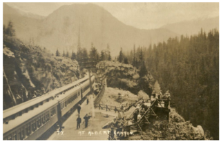
Albert Canyon is a railway point in the West Kootenay region of southeastern British Columbia. The community was immediately east of the mouth of Albert Creek on the south shore of the Illecillewaet River. That settlement no longer exists, but the Canyon Hot Springs Resort borders to its north. On BC Highway 1, the locality is by road about 33 kilometres (21 mi) northeast of Revelstoke and 30 kilometres (19 mi) southwest of Glacier.

<span class="mw-page-title-main">Kitselas Canyon</span> Canyon in Kitimat-Stikine Regional District, Canada

Kitselas Canyon is a canyon carved by the Skeena River in the Skeena region of west central British Columbia, Canada. Off BC Highway 16, the landmark is by road about 185 kilometres (115 mi) west of Smithers and 20 kilometres (12 mi) northeast of Terrace.

Cedarvale or Meanskinisht is an unincorporated community in the Skeena region of west central British Columbia. Concentrated on the southeastern shore of the Skeena River, no direct link exists to the portion on the northwestern shore. On BC Highway 16, the locality is by road about 130 kilometres (81 mi) northwest of Smithers and 75 kilometres (47 mi) northeast of Terrace.

The Usk Ferry operates on the Skeena River at Usk in the Skeena region of west central British Columbia, Canada. The vessel employs reaction ferry propulsion and cable ferry guidance. Off BC Highway 16, the crossing is by road about 182 kilometres (113 mi) west of Smithers and 23 kilometres (14 mi) northeast of Terrace.

Vallican is an unincorporated community on the west side of the Slocan River in the West Kootenay region of southeastern British Columbia. At the mouth of the Little Slocan River, the locality formerly spanned both sides of the Slocan River. The rural neighbourhood is off BC Highway 6 about 30 kilometres (19 mi) south of Slocan, and 39 kilometres (24 mi) north of Castlegar.

Kildonan is an unincorporated community in the Alberni Inlet-Barkley Sound region of the west coast of southern Vancouver Island, British Columbia. The former steamboat landing and ferry dock is on the east shore of Uchuchklesit Inlet, which branches northwest of the lower reaches of Alberni Inlet. Adjacent to Pacific Rim National Park Reserve, the locality is by road and ferry about 120 kilometres (75 mi) southwest of Port Alberni.

Avola is an unincorporated community in the Thompson region of eastern British Columbia. The former ferry site is on the west shore of the North Thompson River immediately north of the mouth of Avola Creek. Off BC Highway 5, the locality is by road about 190 kilometres (118 mi) northeast of the Kamloops and 40 kilometres (25 mi) south of Blue River.

Beavermouth is about 43 kilometres (27 mi) west of Golden, and about 32 kilometres (20 mi) east of the mid-point of the Connaught Tunnel beneath Rogers Pass, in southeastern British Columbia. At the mouth of the Beaver River, the train station was called Beavermouth, but the adjacent community, which no longer exists, was known as Beaver or Beaver Mouth. Nowadays, the closest road access is to the nearby Kinbasket Lake Resort.

Pacific is a railway point in the Skeena region of west central British Columbia. On the western shore of the Skeena River, no direct link exists to the highway section on the eastern shore near the mouth of Legate Creek. On BC Highway 16, the locality is by road about 164 kilometres (102 mi) west of Smithers and 40 kilometres (25 mi) northeast of Terrace.

Isle Pierre is a railway point in the Nechako Region of central British Columbia. The scattered community straddles the shores of the Nechako River. The west side, off BC Highway 16, is by road about 55 kilometres (34 mi) west of Prince George and 69 kilometres (43 mi) east of Vanderhoof. The east side is by road about 46 kilometres (29 mi) west of Prince George.

Miworth is an unincorporated community on the southeast shore of the Nechako River in the Nechako Region of central British Columbia. The location, via Otway Rd and Miworth Rd, is about 16 kilometres (10 mi) northwest of Prince George.

Chapmans is a locality in the lower Fraser Canyon area of southwestern British Columbia. The place is on the east shore of the Fraser River and north of Alexandra Bridge Park. The locality, on BC Highway 1, is by road about 46 kilometres (29 mi) north of Hope and 64 kilometres (40 mi) south of Lytton.

References