
Madisonville is a city in Madison County, Texas, United States. The population was 4,420 at the 2020 census. It is the county seat of Madison County. Both the City of Madisonville and the County of Madison were named for U.S. President James Madison, the fourth chief executive.

Palacios is a city in Matagorda County, Texas, United States. The population was 4,395 at the 2020 census.

Bridgeport is a city in Wise County, Texas, United States. The population was 5,923 in 2020. In 2009, Bridgeport was named by the Texas Legislature as the Stagecoach Capital of Texas.

Guthrie is an unincorporated community and census-designated place (CDP) in, and the county seat of, King County in the U.S. state of Texas. It is in the northern part of the state, 93 miles (150 km) east of Lubbock. It serves as the principal headquarters of the Four Sixes Ranch. As of the 2010 census, its population was 160.
Independence is an unincorporated community in Washington County, Texas, United States. According to the Handbook of Texas, the community had a population of 140 in 2000. It is located within the Greater Houston metropolitan area.
Wamba is an unincorporated community in Bowie County, Texas, United States. According to the Handbook of Texas, the community had a population of 70 in 2000. It is located within the Texarkana metropolitan area.
Richards is an unincorporated community and census-designated place (CDP) in eastern Grimes County, Texas, United States. The community is located on Farm roads 1486 and 149. The Chicago, Rock Island and Pacific Railroad line passes the east side of the community and Lake Creek flows past to the east.
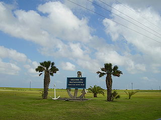
Matagorda is a census-designated place in Matagorda County, Texas. It is located near the mouth of the Colorado River on the upper Texas coast in the United States. In 2020, its population was 313. Matagorda is primarily a tourist town, with commercial and recreational fishing being the top industries. About 23 miles (37 km) of the beach are accessible by vehicle and 35 additional miles are accessible only by boat. Matagorda is at the end of State Highway 60 and the beginning of Farm to Market Road 2031, which runs over the Intracoastal Waterway and south to the Gulf of Mexico.
Blanchard is an unincorporated community located at the junction of Farm Roads 3126 and 2457, about 82 miles north of Houston in Polk County, Texas, United States.

Clairemont is a ghost town in and the former county seat of Kent County, Texas, United States. It is at the intersection of U.S. Route 380 and Texas State Highway 208, 14 mi (23 km) southwest of Jayton and 43 mi (69 km) east of Post. Clairemont lies near the center of Kent County, and the estimated population as of the 2000 census was 15.
Oak Island is an unincorporated community and census-designated place (CDP) in Chambers County, Texas, United States. The population was 371 at the 2020 census.
Dodge is an unincorporated community in eastern Walker County, Texas, United States, on the northern edge of the Sam Houston National Forest. It lies along FM 405 east of the city of Huntsville, the county seat of Walker County. Its elevation is 400 feet (122 m). Although Dodge is unincorporated, it has a post office, with the ZIP code of 77334; the ZCTA for ZIP Code 77334 had a population of 184 at the 2000 census.
Roans Prairie is an unincorporated community in Grimes County, in east central Texas, United States. State Highways 30 and 90 intersect here, seventeen miles northeast of Navasota in central Grimes County.

Welfare, Texas, is an unincorporated community 4 miles (6 km) southeast of Waring on the Waring-Welfare Road in west-central Kendall County, in the U.S. state of Texas. The school was designated a Recorded Texas Historic Landmark in 2000.
Cundiff is an unincorporated hamlet in northeastern Jack County, Texas, United States. The community is approximately 12 miles (19 km) northeast of Jacksboro. It was named for Harrell Cundiff, one of the first settlers of Jack County. There is a church there, and an outfitter, but no other businesses or services.

Posey is an unincorporated community located on the level plains of the Llano Estacado, approximately 11 mi (18 km) southeast of Lubbock in southeastern Lubbock County, Texas, United States.

Steamboat House is located at Sam Houston State University, in the city of Huntsville, county of Walker, in the U.S. state of Texas. Dr. Rufus W. Bailey built the house in 1858 as a wedding gift for his son, but the couple refused to live in it because of its unusual architecture, which caused the locals to give it the nickname "steamboat". It is the house where Sam Houston died July 26, 1863. Houston's funeral was held in the upstairs parlor. The house is part of the Sam Houston Memorial Museum complex.
Markout is an unincorporated community in Kaufman County, located in the U.S. state of Texas. According to the Handbook of Texas, the community had a population of 80 in 2000. It is located within the Dallas/Fort Worth Metroplex.
Raccoon Bend is an unincorporated community in Austin County, in the U.S. state of Texas. According to the Handbook of Texas, the community had a population of 400 in 2000. It is located within the Greater Houston metropolitan area.
Caledonia is an unincorporated community in Rusk County, located in the U.S. state of Texas. According to the Handbook of Texas, the community had a population of 75 in 2000. It is located within the Longview, Texas metropolitan area.


