Skjervøy Municipality is a municipality in Troms county, Norway. The administrative centre of the municipality is the town of Skjervøy on the island of Skjervøya, where most of the inhabitants live. The main industries are fishing and shipbuilding. Other villages in the municipality include Akkarvik and Arnøyhamn.

Nordreisa (Norwegian), Ráisa, or Raisi (Kven) is a municipality in Troms county, Norway. The administrative centre of the municipality is the village of Storslett. Other villages include Oksfjordhamn, Sørkjosen, and Rotsund.

Kvænangen is a municipality in Troms county, Norway. The administrative centre of the municipality is the village of Burfjord. Other notable villages in the municipality include Alteidet, Badderen, Kjækan, and Sekkemo. The European route E6 highway goes through the municipality and over the Sørstraumen Bridge, and many people stop at the Kvænangsfjellet pass to view the scenery of the Kvænangen fjord.

Kvens are a Balto-Finnic ethnic group indigenous to the northern regions of Norway, Sweden, Finland and parts of Russia. In 1996, Kvens were granted minority status in Norway, and in 2005 the Kven language was recognized as a minority language in Norway.

Burfjord (Norwegian), Burovuonna (Northern Sami), or Puruvuono (Kven) is a village in Kvænangen Municipality in Troms county, Norway. The village is the administrative centre of the municipality, thus it is where the municipal offices are located and where the municipal council meets. The 0.59-square-kilometre (150-acre) village has a population (2023) of 390 and a population density of 661 inhabitants per square kilometre (1,710/sq mi).
Sørkjosen (Norwegian), Reaššegeahči (Northern Sami), or Rässikäinen (Kven) is a village in Nordreisa Municipality in Troms county, Norway. The village is located along the shores of the Reisafjorden about 5 kilometres (3.1 mi) northwest of the municipal center of Storslett. Sørkjosen has many industries including fishing, dairy production, and a sawmill.
Alteidet (Norwegian), Duikkáš (Northern Sami), or Tuikkanen (Kven) is a small coastal village along the Lille Altafjord in the eastern part of Kvænangen Municipality in Troms county, Norway. The village is located along European route E6, about 50 km (31 mi) west of the town of Alta in Finnmark county and about 10.5 km (6.5 mi) north of the municipal centre of Burfjord. There are about 130 residents living in the area and one hotel.

Kåfjord (Norwegian), Gávvuonna (Northern Sami), Kaavuono (Kven) is a village in Alta Municipality in Finnmark county, Norway. The village is located along the Kåfjorden, about 18 kilometres (11 mi) west of the town of Alta along the European route E6 highway. The village of Kvenvik lies about 3 kilometres (1.9 mi) to the east, also along the E6 highway.

The Norwegianization of the Sámi was an official policy carried out by the Norwegian government directed at the Sámi people and later the Kven people of northern Norway, in which the goal was to assimilate non-Norwegian-speaking native populations into an ethnically and culturally uniform Norwegian population.

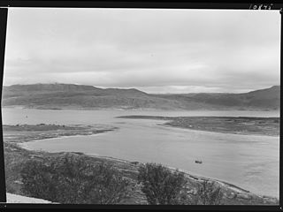
Kvænangen (Norwegian), Návuotna (Northern Sami), or Naavuono (Kven) is a fjord in Troms county, Norway. The fjord runs through Skjervøy Municipality and Kvænangen Municipality.
Sekkemo is a village in Kvænangen Municipality in Troms county, Norway. The village is located along the shore of the Kvænangen fjord, about 12 kilometres (7.5 mi) southwest of the municipal centre of Burfjord. European route E6 runs through the village. Sekkemo Church is located here.
Oksfjorden (Norwegian), Ákšovuotna (Northern Sami), or Aksuvuono (Kven) is a small fjord inlet in Nordreisa Municipality in Troms county, Norway. At the innermost part of the fjord, lies the village of Oksfjordhamn. The European route E06 highway runs along the southern side of the fjord. The fjord empties into the large Reisafjorden to the west.

The Cårrujavrit Hydroelectric Power Station is a hydroelectric power station in Kvænangen Municipality in Troms county, Norway. It utilizes a drop of 305 meters (1,001 ft) between its intake reservoir on the Njemenaiko River and Little Lakes, which is also the reservoir for the Kvænangsbotn Hydroelectric Power Station. Lake Tjoika serves as the reservoir for the plant and is regulated at a level between 529 m (1,736 ft) and 516 m (1,693 ft). The plant has a Francis turbine and operates at an installed capacity of 1.7 MW, with an average annual production of about 11 GWh. The plant is controlled by Kvænangen Kraftverk AS, with a 48.2% share owned by Troms Kraft.

The Kvænangsbotn Hydroelectric Power Station is a hydroelectric power station in Kvænangen Municipality in Troms county, Norway. It utilizes a drop of 305 meters (1,001 ft) between its intake reservoir at Little Lakes and South Fjord. The reservoir is regulated at a level between 315 m (1,033 ft) and 305 m (1,001 ft). The Abo River is also utilized by the power plant. Water is supplied to the reservoir by the Småvatna, Lassajavre, and Cårrujavrit Hydroelectric Power Stations. The plant came into operation in 1965. In 1999 the company received a license to transfer water from the Brenn River, Šleađui River, and Olbmá River. The plant has a Francis turbine and operates at an installed capacity of 44 MW, with an average annual production of about 176 GWh. The plant is controlled by Kvænangen Kraftverk AS, with a 48.2% share owned by Troms Kraft.

The Lassajavre Hydroelectric Power Station is a hydroelectric power station in Kvænangen Municipality in Troms county, Norway. The plant utilizes a drop between Lake Abo and Lake Lassa. Lake Abo is regulated at a level between 689 meters (2,260 ft) and 669 m (2,195 ft), and Lake Lassa serves as the reservoir for the Småvatna Hydroelectric Power Station. The Lassajavre plant also utilizes water from Lake Mollis and Lake Sarves. The plant came into operation in 1977. It has a Francis turbine and operates at an installed capacity of 7.2 MW, with an average annual production of about 30 GWh. The plant is controlled by Kvænangen Kraftverk AS, with a 48.2% share owned by Troms Kraft.
County Road 7958 is 5.18 kilometers (3.22 mi) long and runs between Nordstraumen and Kjøllefjord in Kvænangen Municipality in Troms County, Norway. The road branches off of European route E6 and circles around the Sekkemo marsh to the north and runs along the edge of Kvænangen fjord until connecting with County Road 367. Farms occupy the land descending from the road to the fjord, and the land above the road is covered in low-growing deciduous trees and heather. Historically, the road was called County Road 361.

Badderen (Norwegian), Báttár (Northern Sami), or Paattari (Kven) is a village in Kvænangen Municipality in Troms county, Norway. It lies at the head of the Badderfjord, about 13 kilometers (8.1 mi) south of the municipal seat of Burfjord. The European route E6 highway passes through the village. The basic statistical unit (grunnkrets) of Badderen, which also includes the hamlet of Undereidet, had a population of 183 in 2015.

The Kåfjord Copper Works was a company established in 1826 to mine copper in the village of Kåfjord in what is now Alta Municipality in Finnmark county, Norway.
The Quenangen Mining Association was an English industry that operated copper mines in the area surrounding the Kvænangen fjord in Northern Norway in the 1800s.
The Kven flag has been officially used as a symbol to represent the Kven people of Norway, Sweden, and Finland since 2009. It was designed by Bengt Johansson-Kyrö.