
Urbanice is very small village in the Pardubice Region of the Czech Republic. It has around 73 inhabitants.
Grande Sido is one of three departments in Moyen-Chari, a region of Chad. Its capital is Maro.

Godzięcin is a village in the administrative district of Gmina Brzeg Dolny, within Wołów County, Lower Silesian Voivodeship, in south-western Poland. Prior to 1945 it was in Germany.
Ortel Książęcy Pierwszy is a village in the administrative district of Gmina Biała Podlaska, within Biała Podlaska County, Lublin Voivodeship, in eastern Poland. It lies approximately 12 kilometres (7 mi) south-east of Biała Podlaska and 94 km (58 mi) north-east of the regional capital Lublin.

Koturlu is a village in the Kalbajar Rayon of Azerbaijan.
Karaakhmedli is a village in the Neftchala Rayon of Azerbaijan.
Spitakşen is a village in the Shamkir Rayon of Azerbaijan.
Zofiów is a village in the administrative district of Gmina Biała Rawska, within Rawa County, Łódź Voivodeship, in central Poland. It lies approximately 4 kilometres (2 mi) south-west of Biała Rawska, 15 km (9 mi) east of Rawa Mazowiecka, and 69 km (43 mi) east of the regional capital Łódź.
Ostrożeń Trzeci is a village in the administrative district of Gmina Żelechów, within Garwolin County, Masovian Voivodeship, in east-central Poland. It lies approximately 9 kilometres (6 mi) south-west of Żelechów, 19 km (12 mi) south-east of Garwolin, and 74 km (46 mi) south-east of Warsaw.

Sundbyberg Church is the main church of Sundbyberg, in Sweden, and is a part of the Church of Sweden. It is located in Central Sundbyberg, on Rosengatan 15. Opened in 1911, it was built in a Swedish church building architecture after drawings of architect Axel Sjögren (1877-1962).
Bukownica is a village in the administrative district of Gmina Krobia, within Gostyń County, Greater Poland Voivodeship, in west-central Poland. It lies approximately 4 kilometres (2 mi) north of Krobia, 8 km (5 mi) south of Gostyń, and 65 km (40 mi) south of the regional capital Poznań.
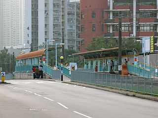
Ching Chung or Tsing Chung is an at-grade MTR Light Rail stop located at Tsing Lun Road in Tuen Mun District, near Ching Chung Koon. It commenced on 23 September 1988 and belongs to Zone 3. It serves the Ching Chung Koon and Castle Peak Hospital.
Zosin is a village in the administrative district of Gmina Kępno, within Kępno County, Greater Poland Voivodeship, in west-central Poland. It lies approximately 3 kilometres (2 mi) north of Kępno and 142 km (88 mi) south-east of the regional capital Poznań.
Łęczyn is a village in the administrative district of Gmina Dobiegniew, within Strzelce-Drezdenko County, Lubusz Voivodeship, in western Poland.
Podębie is a settlement in the administrative district of Gmina Barlinek, within Myślibórz County, West Pomeranian Voivodeship, in north-western Poland. It lies approximately 4 kilometres (2 mi) south-east of Barlinek, 25 km (16 mi) east of Myślibórz, and 66 km (41 mi) south-east of the regional capital Szczecin.

Rataje is a municipality and village in Benešov District in the Central Bohemian Region of the Czech Republic.
Colorado, Paraná is a municipality in the state of Paraná in the Southern Region of Brazil.
Guaraci, Paraná is a municipality in the state of Paraná in the Southern Region of Brazil.
The Irtysh–Karaganda Canal is an irrigation canal in Kazakhstan. It connects the Irtysh River with Karaganda (Qaraghandy), a major industrial center in north-central Kazakhstan. After Kazakhstan's independence, the canal has been officially known as Kanysh Satpayev Canal. named so after the Kazakh geologist Kanysh Satpayev.

Locust Grove is an unincorporated community in Boston Township, Wayne County, in the U.S. state of Indiana.


