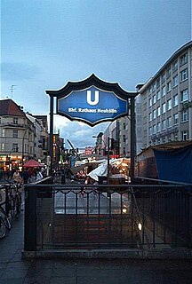
Rathaus Neukölln is a Berlin U-Bahn station located on the U 7. It was built in 1926 by A. Grenander. The platform was extended in 1968. In 1989 a lift was built in. It was the first subway station in Neukölln that was handicap-accessible. The next stop is Karl-Marx-Straße.

Brzezina is a village in the administrative district of Gmina Twardogóra, within Oleśnica County, Lower Silesian Voivodeship, in south-western Poland. Prior to 1945 it was in Germany.
Łabędzin is a village in the administrative district of Gmina Piotrków Kujawski, within Radziejów County, Kuyavian-Pomeranian Voivodeship, in north-central Poland.
Starorypin Prywatny is a village in the administrative district of Gmina Rypin, within Rypin County, Kuyavian-Pomeranian Voivodeship, in north-central Poland. It lies approximately 3 kilometres (2 mi) north-west of Rypin and 56 km (35 mi) east of Toruń.
Żuki is a village in the administrative district of Gmina Sokółka, within Sokółka County, Podlaskie Voivodeship, in north-eastern Poland, close to the border with Belarus. It lies approximately 7 kilometres (4 mi) north-west of Sokółka and 41 km (25 mi) north-east of the regional capital Białystok.
Jaczno is a village in the administrative district of Gmina Dąbrowa Białostocka, within Sokółka County, Podlaskie Voivodeship, in north-eastern Poland. It lies approximately 6 kilometres (4 mi) east of Dąbrowa Białostocka, 28 km (17 mi) north of Sokółka, and 62 km (39 mi) north of the regional capital Białystok.
Zaborów is a settlement in the administrative district of Gmina Zadzim, within Poddębice County, Łódź Voivodeship, in central Poland. It lies approximately 8 kilometres (5 mi) east of Zadzim, 15 km (9 mi) south of Poddębice, and 35 km (22 mi) west of the regional capital Łódź.
Książ Mały-Kolonia is a village in the administrative district of Gmina Książ Wielki, within Miechów County, Lesser Poland Voivodeship, in southern Poland. It lies approximately 7 kilometres (4 mi) east of Książ Wielki, 17 km (11 mi) north-east of Miechów, and 47 km (29 mi) north-east of the regional capital Kraków.
Kałków is a village in the administrative district of Gmina Pawłów, within Starachowice County, Świętokrzyskie Voivodeship, in south-central Poland. It lies approximately 5 kilometres (3 mi) east of Pawłów, 13 km (8 mi) south-east of Starachowice, and 40 km (25 mi) east of the regional capital Kielce.
Karolów is a village in the administrative district of Gmina Sienno, within Lipsko County, Masovian Voivodeship, in east-central Poland.
Ostrów-Kania is a village in the administrative district of Gmina Dębe Wielkie, within Mińsk County, Masovian Voivodeship, in east-central Poland. It lies approximately 2 kilometres (1 mi) north-west of Dębe Wielkie, 10 km (6 mi) west of Mińsk Mazowiecki, and 30 km (19 mi) east of Warsaw.
Wójty-Trojany is a village in the administrative district of Gmina Gzy, within Pułtusk County, Masovian Voivodeship, in east-central Poland.
Nowopole is a village in the administrative district of Gmina Siemiątkowo, within Żuromin County, Masovian Voivodeship, in east-central Poland. It lies approximately 6 kilometres (4 mi) west of Siemiątkowo, 19 km (12 mi) south of Żuromin, and 104 km (65 mi) north-west of Warsaw.
Antoniówka is a village in the administrative district of Gmina Jedlnia-Letnisko, within Radom County, Masovian Voivodeship, in east-central Poland. It lies approximately 4 kilometres (2 mi) west of Jedlnia-Letnisko, 10 km (6 mi) north-east of Radom, and 90 km (56 mi) south of Warsaw.
Pijanowice is a village in the administrative district of Gmina Krobia, within Gostyń County, Greater Poland Voivodeship, in west-central Poland. It lies approximately 5 kilometres (3 mi) north of Krobia, 8 km (5 mi) south-west of Gostyń, and 65 km (40 mi) south of the regional capital Poznań.
Pagórki is a village in the administrative district of Gmina Wierzbinek, within Konin County, Greater Poland Voivodeship, in west-central Poland.
Proboszczowice is a village in the administrative district of Gmina Toszek, within Gliwice County, Silesian Voivodeship, in southern Poland. It lies approximately 8 kilometres (5 mi) west of Toszek, 25 km (16 mi) north-west of Gliwice, and 47 km (29 mi) north-west of the regional capital Katowice.
Tarnówek is a village in the administrative district of Gmina Witnica, within Gorzów County, Lubusz Voivodeship, in western Poland.
Malczkówko is a village in the administrative district of Gmina Potęgowo, within Słupsk County, Pomeranian Voivodeship, in northern Poland. It lies approximately 10 kilometres (6 mi) south-west of Potęgowo, 22 km (14 mi) east of Słupsk, and 84 km (52 mi) west of the regional capital Gdańsk.
Borzyszkowo is a village in the administrative district of Gmina Darłowo, within Sławno County, West Pomeranian Voivodeship, in north-western Poland. It lies approximately 9 kilometres (6 mi) east of Darłowo, 12 km (7 mi) north-west of Sławno, and 172 km (107 mi) north-east of the regional capital Szczecin.


