Koch-Goma

Last updated

Koch-Goma
Uganda location map.svg
Red pog.svg
Koch-Goma
Map of Uganda showing location of Koch-Goma
Coordinates: 02°36′16″N32°10′25″E / 2.60444°N 32.17361°E / 2.60444; 32.17361 Coordinates: 02°36′16″N32°10′25″E / 2.60444°N 32.17361°E / 2.60444; 32.17361
CountryFlag of Uganda.svg  Uganda
Region Northern Region
Sub-region Acholi sub-region
District Nwoya District
Elevation
997 m (3,271 ft)
Population
 (2014 Census)
  Total15,000
Time zone UTC+3 (EAT)

Koch-Goma, also Koch Goma, is a human settlement in Nwoya District, in the Northern Region of Uganda. [1]

Contents

Location

The town lies in Nwoya District, approximately 21 kilometres (13 mi) by road, east of Nwoya Town, where the district headquarters are located. [2]

Koch-Goma is located approximately 25 kilometres (16 mi), southwest of Gulu, the largest city in the Northern Region of Uganda, [3] along a new asphalt-topped road. [1]

The geographical coordinates of Koch-Goma are: 2°36'16.0"N, 32°10'25.0"E (Latitude:2.604444; Longitude:32.173611). [4] Koch-Goma sits at an average elevation of 997 metres (3,271 ft), above sea level. [5]

Overview

In July 2019, Koch-Goma was reported to be the fastest-growing settlement in Nwoya District, according to the Daily Monitor newspaper. It is a nascent urban centre which is also the headquarters of Koch-Goma sub-county. [1]

Population

Th national census and household population survey enumerated the population of Koch-Goma at 15,000 people. [1]

Education

The available schools in the community range from nursery schools, elementary school and secondary schools. The schools range from private, community and government schools. They include (a) Koch-Goma Central Primary School (b) Coo-Rom Primary School (c) Kalang Primary School (d) Ter-Okono Community School and (e) Koch-Goma Senior Secondary School, among others. [1]

Energy

As of July 2019, Koch-Goma was not yet connected to Uganda's national electricity grid. Those with electric connections use private solar energy installations. [1]

Agriculture

The soils around Koch-Goma are very fertile. Crops supported include cotton, cassava and sim sim. The sub-county is a leading supplier of sim sim in Uganda. [1]

Related Research Articles

<span class="mw-page-title-main">Gulu District</span> Neucleated District in Northern Region of Uganda, Uganda

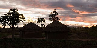
Gulu is a City in the Northern Region of Uganda. The regional headquarters are located in the city of Gulu, which is also the administrative capital of Northern Uganda The city consist of two main divisions... Gulu west and Gulu east.

<span class="mw-page-title-main">Pader District</span> District in Northern Uganda, Uganda

Pader District is a district in Northern Uganda. It is named after Pader, the chief municipal, administrative and commercial town in the district, where the district headquarters are located.

<span class="mw-page-title-main">Oyam District</span> District in Northern Uganda, Uganda

Oyam District is a district in Northern Uganda. Like most Ugandan districts, it is named after its 'chief town', Oyam, where the district headquarters are located.

<span class="mw-page-title-main">Amuru District</span> District in Northern Uganda, Uganda

Amuru District is a district in Northern Uganda. Like most Ugandan districts, it is named after its 'chief town', Amuru, where the district headquarters are located.

Anaka is a town in the Northern Region of Uganda. It is the site of the Nwoya District headquarters.

Sheema, also Sheema Municipality, is an urban centre in the Western Region of Uganda. It is the largest municipality in Sheema District.

<span class="mw-page-title-main">Nwoya District</span> District in Northern Uganda, Uganda

Nwoya District is a district in Northern Uganda. Like most districts in Uganda, it is named after its main municipal, administrative and commercial center, Nwoya, the location of the district headquarters.

Nwoya is a town in Nwoya District in the Acholi sub-region, in the Northern Region of Uganda. It is the main municipal, administrative, and commercial centre of the district. Nwoya Town Council is classified as a municipality.

<span class="mw-page-title-main">Agago District</span> District in Northern Uganda, Uganda

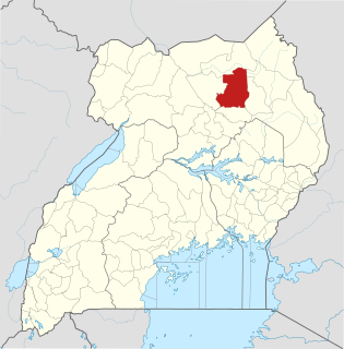
The Agago District is a Ugandan district located in North east Uganda.

The Acholibur–Gulu–Olwiyo Road is a road in the Northern Region of Uganda, connecting the town of Acholibur to the city of Gulu and the town of Olwiyo.

Olwiyo is a town in Nwoya District in the Northern Region of Uganda.

Elegu is a town in the Northern Region of Uganda. It sits across the international border from the town of Nimule, South Sudan.

Bukeerere, sometimes wrongly spelled as Bukerere, is a township in the Central Region of Uganda. The correct phonetic spelling is with two 'e's after the 'k'.

Gulu Military Hospital is a hospital in Gulu, in the Northern Region of Uganda.

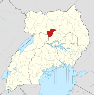
Omoro District is a district in the Northern Region of Uganda.

Maya is a town in the Central Region of Uganda. It is one of the urban centers in Wakiso District.

Mbalwa is a neighborhood in Kyaliwajjala Parish, Kira Municipality, Wakiso District in the Central Region of Uganda.

Lorengecora is a settlement in the Northern Region of Uganda. It is the headquarters of Lorengecora Parish, in Iriri sub-county, in Bokora County, in Napak District, in the Karamoja sub-region.

Kijabijo is a neighborhood in Kira Town, in Wakiso District in the Buganda Region of Uganda.

Bihanga is a settlement in Ibanda District in the Western Region of Uganda. It is the location of the headquarters of Bihanga Parish, Nyamarebe sub-county.

References

  1. 1 2 3 4 5 6 7 Polycarp Kalokwera (17 July 2019). "Invest in fast growing Koch Goma". Daily Monitor . Kampala. Retrieved 17 July 2019.
  2. Globefeed.com (17 July 2019). "Distance between Nwoya, Nwoya District, Northern Region, Uganda and Koch-Goma, Nwoya District, Uganda". Globefeed.com. Retrieved 17 July 2019.
  3. Globefeed.com (17 July 2019). "Distance between Gulu, Uganda and Koch-Goma, Nwoya District, Uganda". Globefeed.com. Retrieved 17 July 2019.
  4. Google (17 July 2019). "Location of Koch-Goma, Uganda" (Map). Google Maps . Google. Retrieved 17 July 2019.
  5. Mapcarta (2019). "Elevation of Koch-Goma, Uganda". Mapcarta.com. Retrieved 17 July 2019.