
The Bodoland Territorial Region (BTR) is an autonomous division in Assam, India, and a proposed state in Northeast India. It is made up of four districts on the north bank of the Brahmaputra River below the foothills of Bhutan and Arunachal Pradesh. It is administered by an elected body known as the Bodoland Territorial Council which came into existence under the terms of a peace agreement signed in February 2003 and its autonomy was further extended by an agreement signed in January 2020. The region covers an area of over nine thousand square kilometres and is predominantly inhabited by the Bodo people and other indigenous communities of Assam.

The Dooars or Duars are the alluvial floodplains in eastern-northeastern India and southern Bhutan that lie south of the outer foothills of the Himalayas and north of the Brahmaputra River basin. This region is about 30 km (19 mi) wide and stretches over about 350 km (220 mi) from the Teesta River in West Bengal to the Dhansiri River in Udalguri district of Assam. The region forms the gateway to Bhutan. It is part of the Terai-Duar savanna and grasslands ecoregion.

Nagaon is a city and a municipal board in Nagaon district in the Indian state of Assam. It is situated 122.6 kilometres (76 mi) east of Guwahati.
Chirang District is an administrative district in the Bodoland Territorial Region of Assam state in the North-East of India.
Basugaon (IPA:ˈbɑːsʊˌgɑ̃ʊ) is a Town in Chirang District of Assam, India. It is an industrial town and a Municipal Board area. It is a neighbourhood of Bongaigaon UA, and it is situated approximately 180 km from Guwahati City in the western part of the Lower Assam Region. The name of this town is derived from its high bamboo plantation and bamboo market basically "basu" or "bash" means bamboo and "gaon" means village that is Basugaon, 'The village of bamboo'.
Bijni is a town in Chirang district under the jurisdiction of Bodoland Territorial Council which controls the districts of the Bodoland Territorial Region in the state of Assam.

Baksa district is an administrative district in the Bodoland Territorial Region of Assam, one of the North-Eastern states of India. The administrative headquarters is at Mushalpur. Manas National Park is a part of this district.

Lower Assam division is one of the 5 administrative divisions of Assam in India. It was formed in 1874, consisting of the undivided Kamrup district of Western Assam, undivided Darrang and Nagaon districts of Central Assam and Khasi & Jaintia hills of Meghalaya, created for revenue purposes. The division is under the jurisdiction of a Commissioner, who is stationed at Guwahati. The division currently covers the Western Brahmaputa Valley. Shri Jayant Narlikar, IAS is the current Commissioner of Lower Assam division.
Dangtola is a village in the Chirang district of the north eastern state of Assam.

Bijni Assembly constituency is one of the 126 state legislative assembly constituencies in Assam state in North Eastern India. It is also one of the 10 state legislative assembly constituencies included in the Kokrajhar Lok Sabha constituency.
Bijni College is an undergraduate college is situated on the Indo-Bhutan border, Bijni. The college is established in the year 1969 at Bijni of Chirang district in Assam. The college is affiliated to Bodoland University.
The Boro Baptist Church Association (BBCA) is a Baptist Christian denomination in the state of Assam. Established in 1927 by the American Baptist Missionaries and later nurtured by Australian Baptist Missionary Society ABMS. The BBCA has its headquarters in the Tukrajhar Baptist Mission compound in Chirang district of Bodoland, Assam. BBCA is working in partnership with Baptist World Alliance, Global Interaction (Australia), Asia Pacific Baptist Federation, Seva Bharat, Missionaries Upholders Trust, Inspire India and Tura Baptist Church.
The Brahmaputra floods refers to a catastrophic flood event that occurred in 2012 along the Brahmaputra River and its tributaries, as well as in subsequent years.
Bodoland Martyrs Gold Cup is a football tournament in the Bodoland Territorial Region, Assam, India, organised by Kokrajhar District Sports Association (KDSA). It is played in memory of Bodoland martyrs, who sacrificed their lives for the cause of Bodoland movement.

The Aie River is a tributary of the Manas River in the Indian state of Assam. The river originates from Black Mountains (Bhutan). The Aie river flows through the Chirang district of Assam and joins Manas river at Bangpari of Chirang district. Aie means mother in Bodo language. The Dwijing Festival is an annual festival set on the banks of Aie river near the Hagrama bridge of Chirang district which is a colorful celebration of Assam's culture.
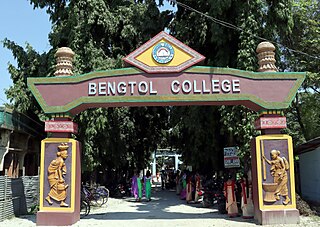
Bengtol College, is the higher educational institution located in the district of Chirang, Assam, India. It is 17 km (11 mi) from NH-31 and 24 km (15 mi) from Bongaigaon The college is affiliated to Bodoland University.

United Chirang Duar Football Club is an Indian professional football club based in Chirang, Bodoland, Assam. It is the first professional club from Bodoland to participate in I-League 2 qualifiers. The club was qualified to play in the tournament after beating Elevenstar Club in the qualifying round organised by Assam Football Association. It currently competes in I-League 3 and the Assam State Premier League.

Kalamati is a popular picnic spot located north of Chirang district,Bodoland Territorial Region,Assam, India, and shares a border with Bhutan.
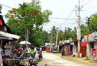
Bengtol is a town in Chirang District in the Indian state of Assam. It is governed by Bengtol Gram Panchayat. The nearest city is Bongaigaon, about 25 kilometers away.
Patabari, commonly known as Patabari Island or Patabari Village, is located in Bengtol Subdivision, Chirang district in Assam, India. Kajalgaon and Bengtol are the district and sub-district headquarters of Patabari. The nearest city is Bongaigaon which is about 37 km away from Patabari.


