Koke'e State Park

Last updated
Kōke'e State Park

Kalalau Valley viewed from the Na Pali Kona Forest Reserve Pihea Trail.jpg

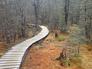
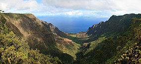
Kalalau Valley viewed from the Pihea Trail
Location Map Kauai.png
Red pog.svg
USA Hawaii location map.svg
Red pog.svg
Location Kauaʻi, United States
Coordinates 22°7′49″N159°39′32″W / 22.13028°N 159.65889°W / 22.13028; -159.65889
Governing body Hawaii Department of Land and Natural Resources
Overlooking the Kalalau Valley from Koke'e State Park Kokee.jpg
Overlooking the Kalalau Valley from Koke'e State Park

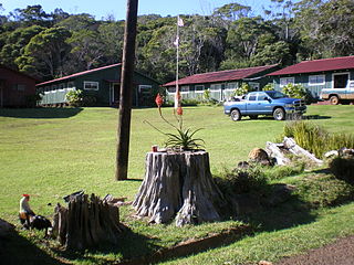
Kōkeʻe State Park is located in northwestern Kauaʻi in the Hawaiian Islands. It includes the Kōkeʻe Museum at the 15 mi (24 km) marker on State Road 550, which focuses on the weather, vegetation, and bird life; a lodge which serves food and sells gifts; cabins for rent; and hiking trails. The park is just north of Waimea Canyon State Park at 22°7′49″N159°39′32″W / 22.13028°N 159.65889°W / 22.13028; -159.65889 Coordinates: 22°7′49″N159°39′32″W / 22.13028°N 159.65889°W / 22.13028; -159.65889 and includes 4,345 acres (17.58 km2) of mountainous terrain.

Kauai Island of the Hawaiian Island Chain

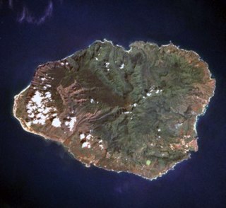
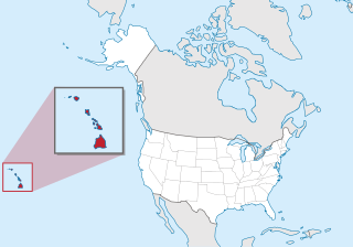
Kauaʻi, anglicized as Kauai, is geologically the oldest of the main Hawaiian Islands. With an area of 562.3 square miles (1,456.4 km2), it is the fourth-largest of these islands and the 21st largest island in the United States. Known also as the "Garden Isle", Kauaʻi lies 105 miles (169 km) across the Kauaʻi Channel, northwest of Oʻahu. This island is the site of Waimea Canyon State Park.

Hawaiian Islands An archipelago in the North Pacific Ocean, currently administered by the US state of Hawaii

The Hawaiian Islands are an archipelago of eight major islands, several atolls, numerous smaller islets, and seamounts in the North Pacific Ocean, extending some 1,500 miles from the island of Hawaiʻi in the south to northernmost Kure Atoll. Formerly the group was known to Europeans and Americans as the Sandwich Islands, a name chosen by James Cook in honor of the then First Lord of the Admiralty John Montagu, 4th Earl of Sandwich. The contemporary name is derived from the name of the largest island, Hawaii Island.

Route 550 is a fourteen-mile (21 km) road stretching from Route 50 in Waimea to Kōkeʻe State Park on the island of Kauai.

Contents

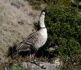
The main attractions of Kōkeʻe State Park trails are the native vegetation, native forest birds, and the scenic cliffside views. Situated on a plateau between 3,200 and 4,200 ft (980 and 1,280 m), much of Kōkeʻe is a montane (infrequent frost) mesic forest (50 to 100 in or 1,300 to 2,500 mm annual rainfall with moist soil conditions) dominated by koa ( Acacia koa ) and ʻōhiʻa lehua ( Metrosideros polymorpha ) trees. The park receives around 70 inches (1,800 mm) of rain per year, mostly from October to May.

Plateau An area of a highland, usually of relatively flat terrain

In geology and physical geography, a plateau, also called a high plain or a tableland, is an area of a highland, usually consisting of relatively flat terrain, that is raised significantly above the surrounding area, often with one or more sides with steep slopes. Plateaus can be formed by a number of processes, including upwelling of volcanic magma, extrusion of lava, and erosion by water and glaciers. Plateaus are classified according to their surrounding environment as intermontane, piedmont, or continental.

<i>Acacia koa</i> species of plant

Acacia koa is a species of flowering tree in the pea family, Fabaceae. It is endemic to the Hawaiian Islands, where it is the second most common tree. The highest populations are on Hawaiʻi, Maui and Oʻahu. Its name in the Hawaiian language, koa, also means brave, bold, fearless, or warrior.

<i>Metrosideros polymorpha</i> species of plant

Metrosideros polymorpha, the ʻōhiʻa lehua, is a species of flowering evergreen tree in the myrtle family, Myrtaceae, that is endemic to the six largest islands of Hawaiʻi. It is a highly variable tree, being 20–25 m (66–82 ft) tall in favorable situations, and a much smaller prostrate shrub when growing in boggy soils or directly on basalt. It produces a brilliant display of flowers, made up of a mass of stamens, which can range from fiery red to yellow. Many native Hawaiian traditions refer to the tree and the forests it forms as sacred to Pele, the volcano goddess, and to Laka, the goddess of hula. ʻŌhiʻa trees grow easily on lava, and are usually the very first plants to grow on new lava flows.

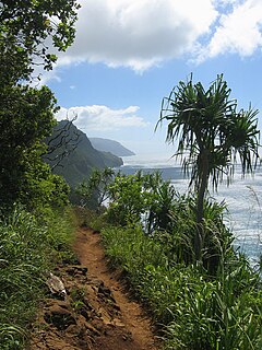
At the end of the state road is a lookout onto the Kalalau Valley, once home to thousands of native Hawaiians. The valley was the backdrop for Jack London's short story Koʻolau the Leper.

Kalalau Valley valley in Kauai County, United States of America

The Kalalau Valley is located on the northwest side of the island of Kauaʻi in the state of Hawaiʻi. The valley is located in the Nā Pali Coast State Park and houses the Kalalau Beach. The Nā Pali Coast is rugged and is inaccessible to automobiles. The only legal ways to access the valley are by kayak or by hiking the Kalalau Trail.

Native Hawaiians ethnic group

Native Hawaiians are the Aboriginal Polynesian people of the Hawaiian Islands or their descendants. Native Hawaiians trace their ancestry back to the original Polynesian settlers of Hawaiʻi. In total, 527,000 Americans consider themselves Native Hawaiian.

Jack London American author, journalist, and social activist

John Griffith London was an American novelist, journalist, and social activist. A pioneer in the world of commercial magazine fiction, he was one of the first writers to become a worldwide celebrity and earn a large fortune from writing. He was also an innovator in the genre that would later become known as science fiction.

In October it is the home of a festival honoring Queen Emma of Hawaii. [1]

Queen Emma of Hawaii Queen consort of King Kamehameha IV from 1856 to his death in 1863

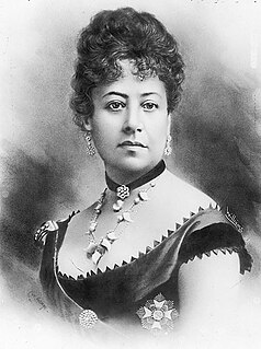
Emma Kalanikaumakaʻamano Kaleleonālani Naʻea Rooke of Hawaiʻi was queen consort of King Kamehameha IV from 1856 to his death in 1863. She ran for ruling monarch against King Kalākaua but was defeated.

Hiking Trails

Vegetation near Waipo`o Falls along the Canyon Trail. Canyon Trail Kauai.jpg
Vegetation near Waipoʻo Falls along the Canyon Trail.
Boardwalk pedestrian walkway along beaches or in nature areas, often built using wooden planks

A boardwalk is an elevated footpath, walkway, or causeway built with wooden planks that enables pedestrians to cross wet, fragile, or marshy land. They are also in effect a low type of bridge. Such timber trackways have existed since at least Neolithic times.

<i>Sequoia sempervirens</i> species of plant of the monotypic genus Sequoia in the cypress family (Cupressaceae)

Sequoia sempervirens is the sole living species of the genus Sequoia in the cypress family Cupressaceae. Common names include coast redwood, coastal redwood and California redwood. It is an evergreen, long-lived, monoecious tree living 1,200–1,800 years or more. This species includes the tallest living trees on Earth, reaching up to 379 feet (115.5 m) in height and up to 29.2 feet (8.9 m) in diameter at breast height (dbh). These trees are also among the oldest living things on Earth. Before commercial logging and clearing began by the 1850s, this massive tree occurred naturally in an estimated 2,100,000 acres (850,000 ha) along much of coastal California and the southwestern corner of coastal Oregon within the United States.

<i>Cryptomeria</i> species of plant

Cryptomeria is a monotypic genus of conifer in the cypress family Cupressaceae, formerly belonging to the family Taxodiaceae. It includes only one species, Cryptomeria japonica. It is endemic to Japan, where it is known as sugi. The tree is called Japanese sugi pine or Japanese red-cedar in English.

See also

Civilian Conservation Corps Camp in Kokee State Park

Civilian Conservation Corps Camp in Koke'e State Park is located at Hawaii Route 550, in Waimea, on the island of Kauai, in the U.S. state of Hawaii. It was built in 1935 with lumber that was put into the saltwater and floated to the shore at Port Allen, the seawater adding a natural termite protection to the lumber. The camp was in continual use for forest management, until Hurricane Iwa devastated it in 1982. In the 1990s it was restored through the efforts of the non-profit Hui O Laka environmental group, and is currently open to the public. It was added to the National Register of Historic Places listings in Hawaii on December 20, 1996.

Related Research Articles

Sequoia National Park national park in the Sierra Nevada mountains, California, USA

Sequoia National Park is an American national park in the southern Sierra Nevada east of Visalia, California. The park was established on September 25, 1890 to protect 404,064 acres of forested mountainous terrain. Encompassing a vertical relief of nearly 13,000 feet (4,000 m), the park contains the highest point in the contiguous United States, Mount Whitney, at 14,505 feet (4,421 m) above sea level. The park is south of, and contiguous with, Kings Canyon National Park; the two parks are administered by the National Park Service together as the Sequoia and Kings Canyon National Parks. UNESCO designated the areas as Sequoia-Kings Canyon Biosphere Reserve in 1976.

Waimea Canyon State Park Protected area of Kauai County, Hawaii, United States

Waimea Canyon, also known as the Grand Canyon of the Pacific, is a large canyon, approximately ten miles (16 km) long and up to 3,000 feet deep, located on the western side of Kauaʻi in the Hawaiian Islands of the United States. Waimea is Hawaiian for "reddish water", a reference to the erosion of the canyon's red soil. The canyon was formed by a deep incision of the Waimea River arising from the extreme rainfall on the island's central peak, Mount Waiʻaleʻale, among the wettest places on earth.

Hawaiian tropical rainforests

The Hawaiian tropical rainforests are a tropical moist broadleaf forest ecoregion in the Hawaiian Islands. They cover an area of 6,700 km2 (2,600 sq mi) in the windward lowlands and montane regions of the islands. Coastal mesic forests are found at elevations from sea level to 300 m (980 ft). Mixed mesic forests occur at elevations of 750 to 1,250 m, while wet forests are found from 1,250 to 1,700 m. Moist bogs and shrublands exist on montane plateaus and depressions. For the 28 million years of existence of the Hawaiian Islands, they have been isolated from the rest of the world by vast stretches of the Pacific Ocean, and this isolation has resulted in the evolution of an incredible diversity of endemic species, including fungi, mosses, snails, birds, and other wildlife. In the lush, moist forests high in the mountains, trees are draped with vines, orchids, ferns, and mosses. This ecoregion includes one of the world's wettest places, the slopes of Mount Waiʻaleʻale, which average 373 in (9,500 mm) of rainfall per year.

Nā Pali Coast State Park

The Nā Pali Coast State Park is a 6,175 acres (2,499 ha) Hawaiian state park located in the center of the rugged 16 miles (26 km) along the northwest side of Kauaʻi, the oldest inhabited Hawaiian island. The Nā Pali coast itself extends southwest starting at Keʻe Beach extending all the way to Polihale State Park. The na pali along the shoreline rise as much as 4,000 feet (1,200 m) above the Pacific Ocean. The state park was formed to protect the Kalalau Valley.

Shasta–Trinity National Forest

The Shasta–Trinity National Forest is a federally designated forest in northern California, USA. It is the largest National Forest in California and is managed by the U.S. Forest Service. The 2,210,485 acre forest encompasses five wilderness areas, hundreds of mountain lakes and 6,278 miles (10,103 km) of streams and rivers. Major features include Shasta Lake, the largest man-made lake in California and Mount Shasta, elevation 14,179 feet (4,322 m).

Kalalau Trail

The Kalalau Trail is a trail along Nā Pali Coast of the island of Kauai in the state of Hawaii. The trail runs approximately 11 miles (18 km) along the island's north shore from Keʻe Beach to the Kalalau Valley. The trail has been named one of the most beautiful, and dangerous, hikes in the world.

Polipoli Spring State Recreation Area

The Polipoli Spring State Recreation Area is a state park of Hawaiʻi in the United States. It is on the island of Maui about ten miles from Kula up the slope of Haleakalā.

<i>Wilkesia gymnoxiphium</i> species of plant

Wilkesia gymnoxiphium, is a species of flowering plant in the sunflower family, Asteraceae, that is endemic to the island of Kauaʻi in Hawaiʻi. It is classified as endangered on the IUCN Red List. Wilkesia is one of three genera, with Argyroxiphium and Dubautia that are believed to be descendant from a single species related to the North American tarweed. The members of these three genera constitute what is called the silversword alliance, a group whose exceedingly close genetic heritage is not reflected in their exceptionally diverse morphologies.

Alakai Wilderness Preserve

The Alakaʻi Wilderness Preserve, popularly known as Alakaʻi Swamp, is a montane wet forest on the Hawaiian island of Kauaʻi. Although the preserve is home to alpine bogs, it is not a true swamp. It is located on a plateau near Mount Waiʻaleʻale, one of the wettest spots on Earth.

ʻAkiapolaʻau species of bird

The ʻakiapōlāʻau, pronounced ah-kee-ah-POH-LAH-OW, is a species of Hawaiian honeycreeper, that is endemic to the island of Hawaii. Its natural habitats are dry and montane moist forests, and the only bird species on the island to occupy the woodpecker niche. The bird is 5.5 inches (14 cm) in length, and has an unusually curved beak-(a specialist species). The ʻakiapolaʻau is a pudgy bird which has a whitish bottom and tail, black legs, yellow chest, orangish head, black face mask and bill and gray black wings. The male's song is either a loud, short pit-er-ieu or a rapid warba-warba. Its various calls include an upslurred whistle, a short cheedle-ee warble, and a short sweet. Due to the recent disappearance of the Maui and Kauai nukupu'us in the 1990s, leading to fears that they may be extinct, the ʻakiapōlāʻau may be the last of its genus. It is the only member of the subgenus Heterorhynchus, which has a woodpecker-like feeding habitat and exclusively preys on insects, in contrast to the nukupu'us, which were both insect-eaters and also hummingbird-like nectarivores.

ʻAnianiau species of bird

The ʻanianiau, pronounced, is a species of Hawaiian honeycreeper that is endemic to upper elevation forests on the island of Kauai.

ʻApapane species of bird

The ʻapapane is a species of Hawaiian honeycreeper that is endemic to Hawaii. The bright crimson feathers of the ʻapapane were once used to adorn the ʻahuʻula (capes), mahiole (helmets), and nā lei hulu of aliʻi. ʻApapane form small flocks when foraging through the canopies of ʻōhiʻa lehua trees, drinking nectar from the flowers and simultaneously pollinating them. They never forage on the forest floor. When flowering of ʻōhiʻa is low and if not part of a flock, ʻapapane will be chased away from flowers by more aggressive competing birds such as the ʻakohekohe and ʻiʻiwi.

‘Akeke‘e species of bird

The ʻakekeʻe is a bird species in the family Fringillidae, where it is placed in the Hawaiian honeycreeper genus Loxops. It is endemic to the island of Kauaʻi where it is found in small numbers in higher elevations. Because of their similar size, shape, and unusual bill, the ʻakekeʻe and the ʻakepa were for some time classified as a single species. This was eventually changed, because of differences in their color, nesting behavior, and calls.

Hawaiʻi creeper species of bird

The Hawaiʻi creeper, Hawaii creeper or ʻalawī is a species of Hawaiian honeycreeper, that is endemic to the Big Island of Hawaiʻi. Its natural habitats are dry forests and montane moist forests at elevations of 1,000–2,300 metres (3,300–7,500 ft). There are a total of 12,000 birds separated into three populations. A fourth population on the western part of the island probably represents migratory birds from one of the existing population. The Hawaiʻi creeper measures 4.5 inches (11 cm) and has drab green plumage. In 2017 the traditional Hawaiian name was rediscovered as 'alawi'.

ʻAkohekohe species of bird

The ʻakohekohe, or crested honeycreeper, is a species of Hawaiian honeycreeper. It is endemic to the island of Maui in Hawaiʻi. Its natural habitat is wet forests dominated by koa and ʻōhiʻa lehua on the windward side of Haleakalā at elevations of 4,200 to 7,100 feet. It is the largest honeycreeper on the island at 6.5 to 7 inches in length. The adults are a glossy black with whitish feathers and stripes going down its side. The underparts are whitish black while the top has orange feathers sticking from wings. The feathers behind the eyes are a reddish color, and have a stream of cream colored feathers coming from the eyes. One of the things that most people recognize about this bird is its whitish gold colored feather crest on its head. The younger birds are brownish black and they do not have the orangish feathers of the parents. The legs and bills are a blackish color. It has a variety of songs. The most well known of the calls is a pair of whee-o, whee-o, being repeated over and over again. Also another well known song is a descending thrill which is done about five seconds apart. It songs include a low chuckling sound, tjook, tjook, chouroup or a rarer song, hur-hur-hur-gluk-gluk-gluk. During a search for the species in the east Maui forests, there were a record of 415 observations over an area of 11,000 acres (45 km2) and at elevations from 4,200 to 7,100 feet above sea level. It has been estimated that there are a total of 3,800 ʻakohekohe left on Maui in two populations separated by the Koʻolau Gap.

Maui parrotbill species of bird

The Maui parrotbill or kiwikiu is a species of Hawaiian honeycreeper, that is endemic to Maui in Hawaii. It can only be found in 50 square kilometres (19 sq mi) of mesic and wet forests at 1,200–2,150 metres (3,940–7,050 ft) on the windward slopes of Haleakalā. This species is critically endangered, with an estimated population of only 500 individuals. Fossil evidence indicates that the bird could at one time be seen in dry forests at elevations as low as 200–300 metres (660–980 ft), as well as on the island of Molokaʻi

Hakalau Forest National Wildlife Refuge

Hakalau Forest National Wildlife Refuge is a protected area on the Big Island of Hawaiʻi. It is one of two units, along with the Kona Forest National Wildlife Refuge that is managed as part of the Big Island National Wildlife Refuge Complex. Access to the Kona Forest is restricted since it contains several endangered species.

<i>Callistosporium vinosobrunneum</i> species of fungus

Callistosporium vinosobrunneum is a species of agaric fungus in the Catathelasmataceae family. Newly described to science in 2011, it is known only from Hawaiʻian montane wet forests on the islands of Hawaiʻi and Kauaʻi.

<i>Marasmius koae</i> species of fungus

Marasmius koae is a species of agaric fungus in the Marasmiaceae family. Newly described to science in 2011, it is known only from Hawaiian montane wet forests. It produces small stemless fruit bodies that grow on the rotting wood of the flowering tree koa.

References

  1. "Eo e Emalani i Alaka'i — The Emalani Festival". Hui o Laka, Kōkeʻe Museum. Retrieved 2010-02-01.