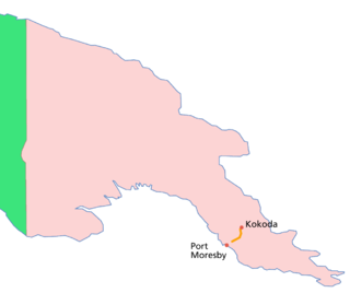
The Kokoda Track or Trail is a single-file foot thoroughfare that runs 96 kilometres (60 mi) overland – 60 kilometres (37 mi) in a straight line – through the Owen Stanley Range in Papua New Guinea (PNG). The track was the location of the 1942 World War II battle between Japanese and Allied – primarily Australian – forces in what was then the Australian territory of Papua.
Maroubra Force was the name given to the ad hoc Australian infantry force that defended Port Moresby, Papua New Guinea from the Japanese, and was involved in the Kokoda Track Campaign of the Pacific War, World War II. The force was established by the Allies under the codename "Maroubra", referring to the troops in the forward area, it was one of many units forming the body of the New Guinea Force, the main Allied army formation in the South West Pacific Area during 1942.
Kokoda is a station town in the Oro Province of Papua New Guinea. It is famous as the northern end of the Kokoda Track, site of the eponymous Kokoda Track campaign of World War II. In that campaign, it had strategic significance because it had the only airfield along the Track. In the decades preceding, it had been a foothills settlement near the gold fields.
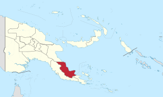
Oro Province, formerly Northern Province, is a coastal province in the Southern Region of Papua New Guinea. The provincial capital is Popondetta. The province covers 22,800 km2, and has 176,206 inhabitants. The province shares land borders with Morobe Province to the northwest, Central Province to the west and south, and Milne Bay Province to the southeast. The province is located within the Papuan Peninsula.

"Fuzzy Wuzzy Angels" was the name given by Australian soldiers to Papua New Guinean war carriers who, during World War II, were recruited or forced into service to bring supplies up to the front and carry injured Australian troops down the Kokoda trail during the Kokoda Campaign.
PNG Air is an airline based on the grounds of Jacksons International Airport, Port Moresby, Papua New Guinea. It operates scheduled domestic and international flights, as well as contract corporate charter work. Its main base is Jacksons International Airport.
Popondetta is the capital of Oro (Northern) Province in Papua New Guinea. Popondetta is a city.
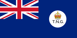
The Territory of New Guinea was an Australian-administered League of Nations and then United Nations trust territory on the island of New Guinea from 1914 until 1975. In 1949, the Territory and the Territory of Papua were established in an administrative union by the name of the Territory of Papua and New Guinea. That administrative union was renamed as Papua New Guinea in 1971. Notwithstanding that it was part of an administrative union, the Territory of New Guinea at all times retained a distinct legal status and identity until the advent of the Independent State of Papua New Guinea.
Kokoda Memorial Hospital is a hospital located in Kokoda, Oro Province, Papua New Guinea. It is located at the northern end of the Kokoda Track. In its first four and a half years of service, it served more than 100,000 patients and delivered more than 500 babies. The hospital was named for those who died in the Kokoda Campaign.
Tabubil Airport is an international airport in Tabubil, Papua New Guinea. Asia Pacific Airlines operates out of Tabubil as its hub.

The South Bird's Head or South Doberai languages are three families of Papuan languages. They form part of the Trans–New Guinea languages in the classifications of Malcolm Ross (2005) and Timothy Usher (2020), though Pawley and Hammarström (2018) do not consider them to be part of Trans–New Guinea. However, according to Dryer (2022), based on a preliminary quantitative analysis of data from the ASJP database, South Bird's Head languages are likely to be a subgroup of Trans–New Guinea.
Sangara is a settlement in south-eastern Papua New Guinea. It is located to the east of Kokoda.
Isurava is a small town in Papua New Guinea, located in Oro Province, on the Kokoda Track. It is the site of the Battle of Isurava that occurred over the period 26 to 31 August 1942, as Australian forces were being pushed back toward Port Moresby by the advancing Japanese. The present site is to the north of the wartime village. It is the site of the Isurava Memorial, constructed in 2002 in remembrance of all those Australians and Papua New Guineans who fought and those who died on the Kokoda Track in 1942.

Airlines PNG Flight 4684 (CG4682/TOK4684) was a scheduled domestic passenger flight operated by Papua New Guinean airliner Airlines PNG, flying from Jacksons International Airport in Papua New Guinea's capital Port Moresby to Kokoda Airport in Oro Province, Papua New Guinea. On 11 August 2009, the aircraft operating the flight, a de Havilland Canada Twin Otter, crashed into a forest in Kokoda Valley, a popular trekking site in Papua New Guinea, while carrying 13 people in bad weather. A search and rescue operation was conducted by authorities and found the wreckage of the crashed plane on the next day, 12 August 2009. The aircraft was severely damaged, and searchers found no signs of life. Papua New Guinean Search and Rescue Agency then announced that everyone on board was killed instantly in the crash.

The Kokoda Track Memorial Walkway is a walking track and war memorial located in the suburb of Concord West, Sydney, New South Wales, Australia. It is located along Brays Bay on the Parramatta River, and is a unique tribute to the Australian troops who fought in the World War II Papua-New Guinea campaign of July 1942 till December 1943.
The Papua New Guinea Accident Investigation Commission (PNGAIC) is an agency of the Government of Papua New Guinea (GoPNG) investigating aviation accidents and serious incidents. The office is located in Level 1, NAQIA Building, Morea-Tobo Road, 6 Mile, National Capital District.

The Kokoda Track Foundation (KTF) is an international aid organisation working in Papua New Guinea. The foundation was established in 2003 and supports the indigenous people of that country. The Foundation provides education, health, and community service programmes such as disaster relief, microbusiness promotion and sustainable ecotourism.

The cuisine of Papua New Guinea are the traditional varied foods found in the eastern part of the New Guinea island. Approximately 80% of the population is reliant on subsistence agriculture, so a large percentage of food energy and protein consumed in Papua New Guinea is produced locally, while the balance is imported. The staple foods in Papua New Guinea includes root crops, bananas, and sago. Papua New Guinea's diet is largely vegetarian, especially in the Gulf and Highlands regions.
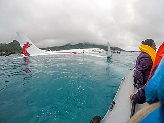
Air Niugini Flight 73 was a scheduled service from Pohnpei, Federated States of Micronesia (FSM) to Port Moresby, Papua New Guinea, via Chuuk, FSM. On 28 September 2018, a Boeing 737, operated by Air Niugini, landed short of the runway at Chuuk International Airport in Weno (FSM) and came to rest in Chuuk Lagoon. Locals in small boats rescued most passengers and all crew members. One passenger was initially declared missing, and was later found dead by rescue divers. Forty-six people survived but six of them were injured.
The Nuclear South Bird's Head, Core South Bird's Head or East South Bird's Head languages form a small language family of western New Guinea. They either form part of a wider South Bird's Head language family, or may be an independent language family if not related to the Inanwatan and Konda–Yahadian languages.


