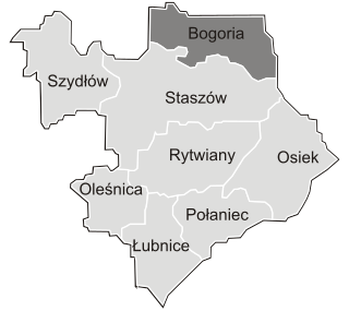
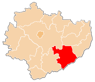
Gorzków is a village in the administrative district of Gmina Bogoria, within Staszów County, Świętokrzyskie Voivodeship, in south-central Poland. It lies approximately 5 kilometres (3 mi) north of Bogoria, 16 km (10 mi) north of Staszów, and 50 km (31 mi) south-east of the regional capital Kielce.
Józefów Witowicki is a colony in the administrative district of Gmina Bogoria, within Staszów County, Świętokrzyskie Voivodeship, in south-central Poland. It lies approximately 7 kilometres (4 mi) east of Bogoria, 15 km (9 mi) north-east of Staszów, and 59 km (37 mi) south-east of the regional capital Kielce.
Kolonia Bogoria is a village in the administrative district of Gmina Bogoria, within Staszów County, Świętokrzyskie Voivodeship, in south-central Poland. It lies approximately 4 kilometres (2 mi) south-west of Bogoria, 9 km (6 mi) north-east of Staszów, and 52 km (32 mi) south-east of the regional capital Kielce.
Kolonia Pęcławice is a village in the administrative district of Gmina Bogoria, within Staszów County, Świętokrzyskie Voivodeship, in south-central Poland. It lies approximately 3 kilometres (2 mi) east of Bogoria, 13 km (8 mi) north-east of Staszów, and 55 km (34 mi) south-east of the regional capital Kielce.
Kolonia Wysoki Małe is a village in the administrative district of Gmina Bogoria, within Staszów County, Świętokrzyskie Voivodeship, in south-central Poland. It lies approximately 4 kilometres (2 mi) north-east of Bogoria, 15 km (9 mi) north-east of Staszów, and 54 km (34 mi) south-east of the regional capital Kielce.
Mała Wieś is a village in the administrative district of Gmina Bogoria, within Staszów County, Świętokrzyskie Voivodeship, in south-central Poland. It lies approximately 3 kilometres (2 mi) north-east of Bogoria, 14 km (9 mi) north-east of Staszów, and 54 km (34 mi) south-east of the regional capital Kielce.
Moszyny is a village in the administrative district of Gmina Bogoria, within Staszów County, Świętokrzyskie Voivodeship, in south-central Poland. It lies approximately 2 kilometres (1 mi) east of Bogoria, 13 km (8 mi) north-east of Staszów, and 54 km (34 mi) south-east of the regional capital Kielce.
Pełczyce is a village in the administrative district of Gmina Bogoria, within Staszów County, Świętokrzyskie Voivodeship, in south-central Poland. It lies approximately 9 kilometres (6 mi) east of Bogoria, 18 km (11 mi) north-east of Staszów, and 60 km (37 mi) south-east of the regional capital Kielce.
Przyborowice is a village in the administrative district of Gmina Bogoria, within Staszów County, Świętokrzyskie Voivodeship, in south-central Poland. It lies approximately 3 kilometres (2 mi) north-west of Bogoria, 14 km (9 mi) north-east of Staszów, and 50 km (31 mi) south-east of the regional capital Kielce.
Rosołówka is a village in the administrative district of Gmina Bogoria, within Staszów County, Świętokrzyskie Voivodeship, in south-central Poland. It lies approximately 4 kilometres (2 mi) south of Bogoria, 9 km (6 mi) north-east of Staszów, and 54 km (34 mi) south-east of the regional capital Kielce.
Ujazdek is a village in the administrative district of Gmina Bogoria, within Staszów County, Świętokrzyskie Voivodeship, in south-central Poland. It lies approximately 7 kilometres (4 mi) north-west of Bogoria, 15 km (9 mi) north of Staszów, and 46 km (29 mi) south-east of the regional capital Kielce.
Wagnerówka is a village in the administrative district of Gmina Bogoria, within Staszów County, Świętokrzyskie Voivodeship, in south-central Poland. It lies approximately 5 kilometres (3 mi) south-east of Bogoria, 14 km (9 mi) north-east of Staszów, and 57 km (35 mi) south-east of the regional capital Kielce.
Witowice is a village in the administrative district of Gmina Bogoria, within Staszów County, Świętokrzyskie Voivodeship, in south-central Poland. It lies approximately 7 kilometres (4 mi) east of Bogoria, 17 km (11 mi) north-east of Staszów, and 59 km (37 mi) south-east of the regional capital Kielce.
Wola Kiełczyńska is a village in the administrative district of Gmina Bogoria, within Staszów County, Świętokrzyskie Voivodeship, in south-central Poland. It lies approximately 3 kilometres (2 mi) north-west of Bogoria, 13 km (8 mi) north-east of Staszów, and 50 km (31 mi) south-east of the regional capital Kielce.
Wola Malkowska is a village in the administrative district of Gmina Bogoria, within Staszów County, Świętokrzyskie Voivodeship, in south-central Poland. It lies approximately 5 kilometres (3 mi) west of Bogoria, 12 km (7 mi) north of Staszów, and 48 km (30 mi) south-east of the regional capital Kielce.
Wolica is a village in the administrative district of Gmina Bogoria, within Staszów County, Świętokrzyskie Voivodeship, in south-central Poland. It lies approximately 5 kilometres (3 mi) east of Bogoria, 16 km (10 mi) north-east of Staszów, and 56 km (35 mi) south-east of the regional capital Kielce.
Wysoki Małe is a village in the administrative district of Gmina Bogoria, within Staszów County, Świętokrzyskie Voivodeship, in south-central Poland. It lies approximately 5 kilometres (3 mi) east of Bogoria, 15 km (9 mi) north-east of Staszów, and 56 km (35 mi) south-east of the regional capital Kielce.
Wysoki Średnie is a village in the administrative district of Gmina Bogoria, within Staszów County, Świętokrzyskie Voivodeship, in south-central Poland. It lies approximately 4 kilometres (2 mi) east of Bogoria, 15 km (9 mi) north-east of Staszów, and 55 km (34 mi) south-east of the regional capital Kielce.
Zagorzyce is a village in the administrative district of Gmina Bogoria, within Staszów County, Świętokrzyskie Voivodeship, in south-central Poland. It lies approximately 5 kilometres (3 mi) east of Bogoria, 16 km (10 mi) north-east of Staszów, and 56 km (35 mi) south-east of the regional capital Kielce.