Kiełczyna

Last updated

Kiełczyna
Village
Poland adm location map.svg
Red pog.svg
Kiełczyna
Coordinates: 50°40′00″N21°14′43″E / 50.66667°N 21.24528°E / 50.66667; 21.24528
CountryFlag of Poland.svg  Poland
Voivodeship Świętokrzyskie
County Staszów
Gmina Bogoria
Sołectwo Kiełczyna
Elevation 303.1 m (994.4 ft)
Population (31 December 2009 at Census) [1]
  TotalIncrease2.svg 435
Time zone CET (UTC+1)
  Summer (DST) CEST (UTC+2)
Postal code28–210
Area code(s) +48 15
Car plates TSZ

Kiełczyna [2] [3] [4] [kʲɛu̯ˈt͡ʂɨna] is a village in the administrative district of Gmina Bogoria, within Staszów County, Świętokrzyskie Voivodeship, in south-central Poland. It lies approximately 2 kilometres (1 mi) north of Bogoria, 14 km (9 mi) north-east of Staszów, and 52 km (32 mi) south-east of the regional capital Kielce. [5]

Gmina Bogoria Gmina in Świętokrzyskie, Poland

Gmina Bogoria is a rural gmina in Staszów County, Świętokrzyskie Voivodeship, in south-central Poland. From 1975–1998 it was part of the former Tarnobrzeg Voivodeship. The gmina seat is the village of Bogoria, which lies approximately 12 kilometres (7 mi) north-east of Staszów and 53 km (33 mi) south-east of the regional capital Kielce.

Staszów County County in Świętokrzyskie, Poland

Staszów County is a unit of territorial administration and local government (powiat) in Świętokrzyskie Voivodeship, south-central Poland. It came into being on January 1, 1999, as a result of the Polish local government reforms passed in 1998. Its administrative seat and largest town is Staszów, which lies 53 kilometres (33 mi) south-east of the regional capital Kielce. The county also contains the towns of Połaniec, lying 17 km (11 mi) south-east of Staszów, and Osiek, 21 km (13 mi) east of Staszów.

Świętokrzyskie Voivodeship Voivodeship in Poland

Świętokrzyskie Voivodeship, Świętokrzyskie Province, or Holy Cross Province is one of the 16 voivodeships (provinces) into which Poland is divided. It is situated in southeastern Poland, in the historical province of Lesser Poland, and takes its name from the Świętokrzyskie mountain range. Its capital and largest city is Kielce.

The village has a population of Increase2.svg 435.

Demography

According to the 2002 Poland census, there were 392 people residing in Kiełczyna village, of whom 51% were male and 49% were female. In the village, the population was spread out with 28.6% under the age of 18, 37.5% from 18 to 44, 17.3% from 45 to 64, and 16.6% who were 65 years of age or older. [1]

Polish census of 2002 was a census in Poland taken from 21 May to 8 June 2002.

Table 1. Population level of village in 2002 – by age group [1]
SPECIFICATIONMeasure
unit
POPULATION
(by age group in 2002)
TOTAL 0–9 10–19 20–29 30–39 40–49 50–59 60–69 70–79 80 +
I. TOTAL person 392 53 76 43 57 53 36 44 20 10
of which in % 100 13.5 19.4 11 14.5 13.5 9.2 11.2 5.1 2.6
1. BY SEX
A. Males person 200 32 38 20 29 34 13 22 8 4
of which in % 51 8.2 9.7 5.1 7.4 8.7 3.3 5.6 2 1
B. Females person 192 21 38 23 28 19 23 22 12 6
of which in % 49 5.4 9.7 5.9 7.1 4.8 5.9 5.6 3.1 1.5
Kie%C5%82czyna


Figure 1. Population pyramid of village in 2002 – by age group and sex [1]
Table 2. Population level of village in 2002 – by sex [1]
SPECIFICATIONMeasure
unit
POPULATION
(by sex in 2002)
TOTAL Males Females
I. TOTAL person 392 200 192
of which in % 100 51 49
1. BY AGE GROUP
A. At pre-working age person 112 61 51
of which in % 28.6 15.6 13
B. At working age. grand total person 215 114 101
of which in % 54.8 29.1 25.7
a. at mobile working age person 147 76 71
of which in                         % 37.5 19.4 18.1
b. at non-mobile working age person 68 38 30
of which in                         % 17.3 9.7 7.6
C. At post-working age person 65 25 40
of which in % 16.6 6.4 10.2

Related Research Articles

Ceber, Świętokrzyskie Voivodeship Village in Świętokrzyskie, Poland

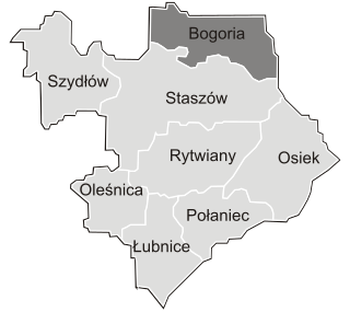
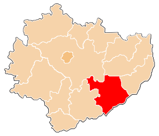
Ceber is a village in the administrative district of Gmina Bogoria, within Staszów County, Świętokrzyskie Voivodeship, in south-central Poland. It lies approximately 5 kilometres (3 mi) north-west of Bogoria, 15 km (9 mi) north of Staszów, and 48 km (30 mi) south-east of the regional capital Kielce.

Domaradzice, Świętokrzyskie Voivodeship Village in Świętokrzyskie, Poland

Domaradzice is a village in the administrative district of Gmina Bogoria, within Staszów County, Świętokrzyskie Voivodeship, in south-central Poland. It lies approximately 7 kilometres (4 mi) east of Bogoria, 18 km (11 mi) north-east of Staszów, and 57 km (35 mi) south-east of the regional capital Kielce.

Gorzków, Staszów County Village in Świętokrzyskie, Poland

Gorzków is a village in the administrative district of Gmina Bogoria, within Staszów County, Świętokrzyskie Voivodeship, in south-central Poland. It lies approximately 5 kilometres (3 mi) north of Bogoria, 16 km (10 mi) north of Staszów, and 50 km (31 mi) south-east of the regional capital Kielce.

Grzybów, Gmina Bogoria Village in Świętokrzyskie, Poland

Grzybów is a village in the administrative district of Gmina Bogoria, within Staszów County, Świętokrzyskie Voivodeship, in south-central Poland. It lies approximately 4 kilometres (2 mi) north-east of Bogoria, 16 km (10 mi) north-east of Staszów, and 53 km (33 mi) south-east of the regional capital Kielce.

Jurkowice, Staszów County Village in Świętokrzyskie, Poland

Jurkowice is a village in the administrative district of Gmina Bogoria, within Staszów County, Świętokrzyskie Voivodeship, in south-central Poland. It lies approximately 8 kilometres (5 mi) east of Bogoria, 17 km (11 mi) north-east of Staszów, and 60 km (37 mi) south-east of the regional capital Kielce.

Kolonia Pęcławska Village in Świętokrzyskie, Poland

Kolonia Pęcławska is a village in the administrative district of Gmina Bogoria, within Staszów County, Świętokrzyskie Voivodeship, in south-central Poland. It lies approximately 6 kilometres (4 mi) east of Bogoria, 15 km (9 mi) north-east of Staszów, and 57 km (35 mi) south-east of the regional capital Kielce.

Łagówka Village in Świętokrzyskie, Poland

Łagówka is a village in the administrative district of Gmina Bogoria, within Staszów County, Świętokrzyskie Voivodeship, in south-central Poland. It lies approximately 9 kilometres (6 mi) north-west of Bogoria, 16 km (10 mi) north of Staszów, and 44 km (27 mi) south-east of the regional capital Kielce.

Mała Wieś, Świętokrzyskie Voivodeship Village in Świętokrzyskie, Poland

Mała Wieś is a village in the administrative district of Gmina Bogoria, within Staszów County, Świętokrzyskie Voivodeship, in south-central Poland. It lies approximately 3 kilometres (2 mi) north-east of Bogoria, 14 km (9 mi) north-east of Staszów, and 54 km (34 mi) south-east of the regional capital Kielce.

Miłoszowice Village in Świętokrzyskie, Poland

Miłoszowice is a village in the administrative district of Gmina Bogoria, within Staszów County, Świętokrzyskie Voivodeship, in south-central Poland. It lies approximately 4 kilometres (2 mi) north-east of Bogoria, 16 km (10 mi) north-east of Staszów, and 52 km (32 mi) south-east of the regional capital Kielce.

Moszyny Village in Świętokrzyskie, Poland

Moszyny is a village in the administrative district of Gmina Bogoria, within Staszów County, Świętokrzyskie Voivodeship, in south-central Poland. It lies approximately 2 kilometres (1 mi) east of Bogoria, 13 km (8 mi) north-east of Staszów, and 54 km (34 mi) south-east of the regional capital Kielce.

Niedźwiedź, Staszów County Village in Świętokrzyskie, Poland

Niedźwiedź is a village in the administrative district of Gmina Bogoria, within Staszów County, Świętokrzyskie Voivodeship, in south-central Poland. It lies approximately 8 kilometres (5 mi) north-west of Bogoria, 14 km (9 mi) north of Staszów, and 45 km (28 mi) south-east of the regional capital Kielce.

Podlesie, Gmina Bogoria Village in Świętokrzyskie, Poland

Podlesie is a village in the administrative district of Gmina Bogoria, within Staszów County, Świętokrzyskie Voivodeship, in south-central Poland. It lies approximately 3 kilometres (2 mi) south-east of Bogoria, 13 km (8 mi) north-east of Staszów, and 55 km (34 mi) south-east of the regional capital Kielce.

Wagnerówka Village in Świętokrzyskie, Poland

Wagnerówka is a village in the administrative district of Gmina Bogoria, within Staszów County, Świętokrzyskie Voivodeship, in south-central Poland. It lies approximately 5 kilometres (3 mi) south-east of Bogoria, 14 km (9 mi) north-east of Staszów, and 57 km (35 mi) south-east of the regional capital Kielce.

Witowice, Świętokrzyskie Voivodeship Village in Świętokrzyskie, Poland

Witowice is a village in the administrative district of Gmina Bogoria, within Staszów County, Świętokrzyskie Voivodeship, in south-central Poland. It lies approximately 7 kilometres (4 mi) east of Bogoria, 17 km (11 mi) north-east of Staszów, and 59 km (37 mi) south-east of the regional capital Kielce.

Wola Kiełczyńska Village in Świętokrzyskie, Poland

Wola Kiełczyńska is a village in the administrative district of Gmina Bogoria, within Staszów County, Świętokrzyskie Voivodeship, in south-central Poland. It lies approximately 3 kilometres (2 mi) north-west of Bogoria, 13 km (8 mi) north-east of Staszów, and 50 km (31 mi) south-east of the regional capital Kielce.

Wola Malkowska Village in Świętokrzyskie, Poland

Wola Malkowska is a village in the administrative district of Gmina Bogoria, within Staszów County, Świętokrzyskie Voivodeship, in south-central Poland. It lies approximately 5 kilometres (3 mi) west of Bogoria, 12 km (7 mi) north of Staszów, and 48 km (30 mi) south-east of the regional capital Kielce.

Wysoki Duże Village in Świętokrzyskie, Poland

Wysoki Duże is a village in the administrative district of Gmina Bogoria, within Staszów County, Świętokrzyskie Voivodeship, in south-central Poland. It lies approximately 3 kilometres (2 mi) north-east of Bogoria, 15 km (9 mi) north-east of Staszów, and 54 km (34 mi) south-east of the regional capital Kielce.

Wysoki Średnie Village in Świętokrzyskie, Poland

Wysoki Średnie is a village in the administrative district of Gmina Bogoria, within Staszów County, Świętokrzyskie Voivodeship, in south-central Poland. It lies approximately 4 kilometres (2 mi) east of Bogoria, 15 km (9 mi) north-east of Staszów, and 55 km (34 mi) south-east of the regional capital Kielce.

Zagorzyce, Świętokrzyskie Voivodeship Village in Świętokrzyskie, Poland

Zagorzyce is a village in the administrative district of Gmina Bogoria, within Staszów County, Świętokrzyskie Voivodeship, in south-central Poland. It lies approximately 5 kilometres (3 mi) east of Bogoria, 16 km (10 mi) north-east of Staszów, and 56 km (35 mi) south-east of the regional capital Kielce.

Zimnowoda, Świętokrzyskie Voivodeship Village in Świętokrzyskie, Poland

Zimnowoda is a village in the administrative district of Gmina Bogoria, within Staszów County, Świętokrzyskie Voivodeship, in south-central Poland. It lies approximately 3 kilometres (2 mi) southwest of Bogoria, 10 km (6 mi) northeast of Staszów, and 52 km (32 mi) south-east of the regional capital Kielce.

References

  1. 1 2 3 4 5 "Local Data Bank (Bank Danych Lokalnych) – Layout by NTS nomenclature (Układ wg klasyfikacji NTS)". demografia.stat.gov.pl: GUS. 10 March 2011.
  2. Bielec, Jan (ed.); Szwałek, Stanisława (1981). Wykaz urzędowych nazw miejscowości w Polsce. T. II: K – P[List of official names of localities in Poland, Vol. II: K – P] (in Polish). Ministry of Administration, Spatial Economy and Environmental Protection (1st ed.). Warsaw, Poland: Central Statistical Office.
  3. Sitek, Janusz (1991). Nazwy geograficzne Rzeczypospolitej Polskiej[Geographical names of the Republic of Poland] (in Polish). Ministry of Physical Planning and Construction, Surveyor General of Poland, Council of Ministers' Office, Commission for Establishing Names of Localities and Physiographical Objects (1st ed.). Warsaw, Poland: Eugeniusz Romer State Cartographical Publishing House. ISBN   83-7000-071-1.
  4. "Kiełczyna, wieś, gmina Bogoria, powiat staszowski, województwo świętokrzyskie" [Kiełczyna, village, Bogoria Commune, Staszów County, Świętokrzyskie Province, Poland]. Topographical map prepared in 1:10,000 scale. Aerial and satellite orthophotomap (in Polish). Head Office of Geodesy and Cartography, Poland, Warsaw. 2011. geoportal.gov.pl. Retrieved 27 April 2011.
  5. "Central Statistical Office (GUS) – TERYT (National Register of Territorial Land Apportionment Journal)" (in Polish). 1 June 2008.


Coordinates: 50°39′47″N21°15′53″E / 50.66306°N 21.26472°E / 50.66306; 21.26472

Geographic coordinate system Coordinate system

A geographic coordinate system is a coordinate system that enables every location on Earth to be specified by a set of numbers, letters or symbols. The coordinates are often chosen such that one of the numbers represents a vertical position and two or three of the numbers represent a horizontal position; alternatively, a geographic position may be expressed in a combined three-dimensional Cartesian vector. A common choice of coordinates is latitude, longitude and elevation. To specify a location on a plane requires a map projection.