Kolukkumalai | |
|---|---|
village | |
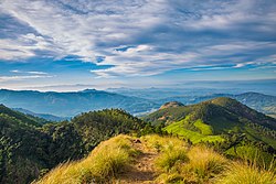 The View of Western Ghats from the Kolukkumalai Peak | |
 Kolukkumalai  Kolukkumalai | |
| Coordinates: 10°04′30″N77°13′16″E / 10.075°N 77.221°E | |
| Country | |
| State | Tamil Nadu |
| District | Theni |
| Government | |
| • Body | Panchayath |
| Elevation | 2,160 m (7,090 ft) |
| Languages | |
| • Official | Tamil |
| Time zone | UTC+5:30 (IST) |
| PIN | 625582 |
| Vehicle registration | TN-60 |
Kolukkumalai is a small village/hamlet in Bodinayakanur Taluk in the Theni district of the Indian state of Tamil Nadu. [1] It is home to the highest tea plantation in the world with the tea grown here possessing a special flavour and freshness because of the high altitude.[ citation needed ] It is located near Munnar in Idukki district of Kerala.

