Chinnakanal

Last updated

Chinnakanal
Village
VIEW FROM CHINNAKANAL.JPG
View from Chinnakanal
India Kerala location map.svg
Red pog.svg
Chinnakanal
Location in Kerala, India
India location map.svg
Red pog.svg
Chinnakanal
Chinnakanal (India)
Coordinates: 10°02′28″N77°10′15″E / 10.04117°N 77.170860°E / 10.04117; 77.170860
CountryFlag of India.svg  India
State Kerala
District Idukki
Area
  Total67.33 km2 (26.00 sq mi)
Population
 (2011)
  Total12,005
  Density180/km2 (460/sq mi)
Languages
  Official Malayalam, English
  Spoken Malayalam,Tamil
Time zone UTC+5:30 (IST)
Chinnakanal falls Chinnakanal falls, Munnar, India.jpg
Chinnakanal falls
Suryanelli Tea estate Suryanelli Tea Forest.jpeg
Suryanelli Tea estate
Indian Black Lored Tit spotted in Chinnakanal Indian black-lored tit.jpg
Indian Black Lored Tit spotted in Chinnakanal

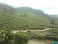
Chinnakanal is a village in Idukki district in the Indian state of Kerala. [1] It has waterfalls which are popularly known as the Power House Waterfalls. [2] [3] Arikomban is a famous elephant that lived in Chinnakanal.

Demographics

As of the 2011 Census, Chinnakanal had a population of 12,005 with 6,098 males and 5,907 females. Chinnakanal village spreads over an area of 67.33 km2 (26.00 sq mi) with 3,210 families residing in it and 9.6% of the population being under 6 years of age. Chinnakanal had an average literacy of 78.6%, 4.6% higher than the national average of 74% and 15.4% lower than state average of 94%; male literacy was 86.2% and female literacy was 70.8%. [4]

Related Research Articles

<span class="mw-page-title-main">Peermade</span> Hill station in Kerala, India

Peermade, also spelt Peerumedu is a village, Grama Panchayat and hill station in the state of Kerala, India. It lies 915 metres (3,002 ft) above sea level in the Western Ghats (Sahyadri) about 85 kilometres (53 mi) east of Kottayam on the way to Thekkady through the nearby city of Kanjirappally.

<span class="mw-page-title-main">Devikulam</span> Village in Kerala, India

Devikulam is a Grama Panchayat and small hill station of about 8 kilometres (5.0 mi) from Munnar in the Idukki District of Kerala State, India. It lies 1,800 metres (5,900 ft) above sea level.

<span class="mw-page-title-main">Kumily</span> Plantation Town in Kerala, India

Kumily also spelt as Kumaly is a revenue village and Gram Panchayat in the Idukki district of Kerala. It is a town in Cardamom Hills near Thekkady and Periyar Tiger Reserve. Kumily is a gateway town into Kerala from Tamil Nadu.

<span class="mw-page-title-main">Udumbanchola</span> Village/Taluk in Kerala, India

Udumbanchola is a taluk in Idukki district of Kerala state in India. This is in the high ranges. Nedumkandam is the major town and capital of Udumbanchola taluk. Mathikettan Shola National Park is located in Udumbanchola.

<span class="mw-page-title-main">Kuttampuzha</span> Village in Kerala, India

Kuttampuzha is a village and gram panchayat in Ernakulam district in the Indian state of Kerala. Situated 71 km east of Kochi, Kuttampuzha panchayat is home to the 17.7% of total area of the Ernakulam District.

Anaviratty is a village in Idukki district in the Indian state of Kerala.

<span class="mw-page-title-main">Ayyappancoil</span> Village in Kerala, India

Ayyappancoil, also spelt Ayyappankovil is a village in newly formed Idukki taluk in Idukki district in the Indian state of Kerala. It is highly noted for the newly constructed suspension bridge with a length of 200 meters and the old historic Sastha temple on the banks of Periyar river.

Chakkupallam is a Grama Panchayat and Village in Idukki district in the Indian state of Kerala. The administrative capital(Panchayat Office) and village center of Chakkupallam Grama Panchayat is Anakkara, located on Kumily-Munnar state highway. The town has a large church, built in 2000.

<span class="mw-page-title-main">Chathurangapara</span> Village in Kerala, India

Chathurangapara is a village in Idukki district in the Indian state of Kerala. The village is part of Udumbanchola and Senapathy Panchayats.

<span class="mw-page-title-main">Kanthalloor</span> Village in Kerala, India

Kanthalloor is a village in Devikulam taluk of Idukki district in the Indian state of Kerala. It is a village nestled in the Western Ghats of India. The salubrious climate and the picturesque landscapes and wide variety of tropical crops coupled with the close proximity of Munnar, has transformed this village into a tourist destination.

<span class="mw-page-title-main">Karunapuram</span> Village in Kerala, India

Karunapuram is a village in Idukki district in the Indian state of Kerala.

<span class="mw-page-title-main">Pallivasal</span> Village in Kerala, India

Pallivasal is a village in Idukki district in the Indian state of Kerala.

<span class="mw-page-title-main">Poopara</span> Village in Kerala, India

Poopara is a village in Idukki district in the Indian state of Kerala. It is located in the cardamom-growing region of Kerala, and also houses a number of tea and coffee plantations. The place also intersects the Munnar - Kumily state highway (SH-19) and Kochi - Dhanushkodi national highway (NH-49). The Anayirankal reservoir is 4 km up the road from Poopara.

Rajakkad is a town in the Idukki district in the Indian state of Kerala situated in the Western Ghats.

<span class="mw-page-title-main">Rajakumari, Idukki district</span> Village in Kerala, India

Rajakumari is a village in Idukki district in the Indian state of Kerala.

Santhanpara is a village in Idukki district in the Indian state of Kerala.

Upputhode is a village in Idukki district in the Indian state of Kerala.

Keezhanthoor is a village in Idukki district in the state of Kerala, India. The village is in the western ghats and is known for growing apples. A Mariyamman Temple and a Vinayagar Temple are the places of devotion

<span class="mw-page-title-main">Kottakamboor</span> Village in Kerala, India

Kottakamboor is a village in Devikulam taluk of Idukki district in the state of Kerala, India.

Mlappara is a village in Idukki district in the state of Kerala, India.

References

  1. "Census of India : Villages with population 5000 & above". Registrar General & Census Commissioner, India. Archived from the original on 8 December 2008. Retrieved 10 December 2008.
  2. "Munnar". Archived from the original on 18 January 2014. Retrieved 21 June 2012.
  3. "Cottages In Chinnakanal". FREE UK Press Release Distribution. Retrieved 23 December 2020.
  4. Kerala, Directorate of Census Operations. District Census Handbook, Idukki (PDF). Thiruvananthapuram: Directorateof Census Operations,Kerala. p. 58,59. Retrieved 14 July 2020.