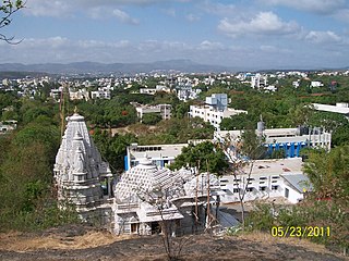
Kondgaon | |
---|---|
village | |
Coordinates: 19°49′03″N72°59′04″E / 19.8175317°N 72.9844401°E Coordinates: 19°49′03″N72°59′04″E / 19.8175317°N 72.9844401°E | |
Country | India |
State | Maharashtra |
District | Palghar |
Taluka | Vikramgad |
Elevation | 56 m (184 ft) |
Population (2011) | |
• Total | 2,049 |
Time zone | UTC+5:30 (IST) |
2011 census code | 551778 |
Kondgaon is a village in the Palghar district of Maharashtra, India. It is located in the Vikramgad taluka. [1]
Palghar District is a district in the state of Maharashtra in Konkan Division. On 1 August 2014, the Maharashtra State government announced the formation of the 36th district of Maharashtra, when a new Palghar District was carved out of the old Thane district. Palghar District starts from Dahanu at the north and ends at Naigaon. It comprises the talukas of Palghar, Vada, Vikramgad, Jawhar, Mokhada, Dahanu, Talasari and Vasai-Virar. At the 2011 Census, the talukas now comprising the district had a population of 2,990,116.
Maharashtra is a state in the western peninsular region of India occupying a substantial portion of the Deccan Plateau. It is the second-most populous state and third-largest state by area in India. Spread over 307,713 km2 (118,809 sq mi), it is bordered by the Arabian Sea to the west, the Indian states of Karnataka and Goa to the south, Telangana to the southeast and Chhattisgarh to the east, Gujarat and Madhya Pradesh to the north, and the Indian union territory of Dadra and Nagar Haveli to the north west. It is also the world's second-most populous subnational entity.
India is a country in South Asia. It is the seventh-largest country by area, the second-most populous country, and the most populous democracy in the world. Bounded by the Indian Ocean on the south, the Arabian Sea on the southwest, and the Bay of Bengal on the southeast, it shares land borders with Pakistan to the west; China, Nepal, and Bhutan to the north; and Bangladesh and Myanmar to the east. In the Indian Ocean, India is in the vicinity of Sri Lanka and the Maldives; its Andaman and Nicobar Islands share a maritime border with Thailand and Indonesia.
According to the 2011 census of India, Kondgaon has 388 households. The effective literacy rate (i.e. the literacy rate of population excluding children aged 6 and below) is 55.68%. [2]
Total | Male | Female | |
---|---|---|---|
Population | 2049 | 995 | 1054 |
Children aged below 6 years | 395 | 196 | 199 |
Scheduled caste | 0 | 0 | 0 |
Scheduled tribe | 2005 | 974 | 1031 |
Literates | 921 | 533 | 388 |
Workers (all) | 1168 | 550 | 618 |
Main workers (total) | 1081 | 517 | 564 |
Main workers: Cultivators | 279 | 190 | 89 |
Main workers: Agricultural labourers | 761 | 303 | 458 |
Main workers: Household industry workers | 2 | 2 | 0 |
Main workers: Other | 39 | 22 | 17 |
Marginal workers (total) | 87 | 33 | 54 |
Marginal workers: Cultivators | 12 | 6 | 6 |
Marginal workers: Agricultural labourers | 61 | 24 | 37 |
Marginal workers: Household industry workers | 1 | 0 | 1 |
Marginal workers: Others | 13 | 3 | 10 |
Non-workers | 881 | 445 | 436 |
Khunavade is a village in the Palghar district of Maharashtra, India. It is located in the Dahanu taluka.
Gaurwadi is a village in the Palghar district of Maharashtra, India. It is located in the Dahanu taluka.
Jamshet is a village in the Palghar district of Maharashtra, India. It is located in the Dahanu taluka.
Jambugaon is a village in the Palghar district of Maharashtra, India. It is located in the Dahanu taluka.
Kosbad is a village in the Palghar district of Maharashtra, India. It is located in the Dahanu taluka.
Kotabi is a village in the Palghar district of Maharashtra, India. It is located in the Dahanu taluka.
Kinhawali is a village in the Palghar district of Maharashtra, India. It is located in the Dahanu taluka.
Kasara is a village in the Palghar district of Maharashtra, India. It is located in the Dahanu taluka.
Kankradi is a village in the Palghar district of Maharashtra, India. It is located in the Dahanu taluka.
Ghadane is a village in the Palghar district of Maharashtra, India. It is located in the Dahanu taluka.
Jingaon is a village in the Palghar district of Maharashtra, India. It is located in the Dahanu taluka.
Ganeshbag is a village in the Palghar district of Maharashtra, India. It is located in the Dahanu taluka.
Ganjad is a village in the Palghar district of Maharashtra, India. It is located in the Dahanu taluka.
Naruli is a village in the Palghar district of Maharashtra, India. It is located in the Dahanu taluka.
Kolhan is a village in the Palghar district of Maharashtra, India. It is located in the Dahanu taluka.
Ghol is a village in the Palghar district of Maharashtra, India. It is located in the Dahanu taluka.
Mhasad is a village in the Palghar district of Maharashtra, India. It is located in the Dahanu taluka.
Gowane is a village in the Palghar district of Maharashtra, India. It is located in the Dahanu taluka.
Kolavali is a village in the Palghar district of Maharashtra, India. It is located in the Dahanu taluka.
Khambale is a village in the Palghar district of Maharashtra, India. It is located in the Dahanu taluka.