
Karimnagar is also known as Elagandula is a city and District Headquarters in the Indian state of Telangana. Karimnagar is a major urban agglomeration and fifth largest City in the state. It is governed by Municipal corporation and is the headquarters of the Karimnagar district It is situated on the banks of Manair River, which is a tributary of the Godavari River.It is the third largest and fastest growing urban settlement in the state, according to 2011 census. It has registered a population growth rate of 45.46% and 38.87% respectively over the past two decades between 1991 and 2011, which is highest growth rate among major cities of Telangana. It serves as a major educational and health hub for the northern districts of Telangana. It is a major business center and widely known for its agricultural and granite industries, earning the nickname "City of Granites."

Telangana is a state in India situated on the south-central stretch of the Indian peninsula on the high Deccan Plateau. It is the eleventh-largest state and the twelfth-most populated state in India with a geographical area of 112,077 km2 (43,273 sq mi) and 35,193,978 residents as per 2011 census. On 2 June 2014, the area was separated from the northwestern part of Andhra Pradesh as the newly formed state of Telangana, with Hyderabad as its capital. Its other major cities include Warangal, Nizamabad, Khammam, Karimnagar and Ramagundam. Telangana is bordered by the states of Maharashtra to the north, Chhattisgarh to the northeast, Karnataka to the west, and Andhra Pradesh to the east and south. The terrain of Telangana consists mostly of the Deccan Plateau with dense forests covering an area of 27,292 km2 (10,538 sq mi). As of 2019, the state of Telangana is divided into 33 districts.

Ganesh Chaturthi, also known as Vinayak Chaturthi, or Ganeshotsav is a Hindu festival commemorating the birth of the Hindu god Ganesha. The festival is marked with the installation of Ganesha's clay idols privately in homes and publicly on elaborate pandals. Observances include chanting of Vedic hymns and Hindu texts, such as prayers and vrata (fasting). Offerings and prasada from the daily prayers, that are distributed from the pandal to the community, include sweets such as modaka as it is believed to be a favourite of Ganesha. The festival ends on the tenth day after start, when the idol is carried in a public procession with music and group chanting, then immersed in a nearby body of water such as a river or sea, called visarjan on the day of Anant Chaturdashi. In Mumbai alone, around 150,000 statues are immersed annually. Thereafter the clay idol dissolves and Ganesha is believed to return to his celestial abode.

Nizamabad is also known as Induru is a city in the Indian state of Telangana. Nizamabad is a major urban agglomeration and third largest city in the state. It is governed by municipal corporation and is the headquarters of the Nizamabad district. Although previously part of Hyderabad State and then Andhra Pradesh state, Nizamabad became a part of the newly formed state of Telangana by the Andhra Pradesh Reorganisation Act, 2014.It is located about 186 kilometres (116 mi) north of the state capital, Hyderabad.

Mahabubnagar district is a district in the Indian state of Telangana. Mahabubnagar is the district headquarters which is popularly known as Palamoor. The district shares boundaries with Narayanapet, Vikarabad, Rangareddy, Nagarkurnool, Wanaparthy and Jogulamba Gadwal districts. The district was formed during the period of the 6th Nizam of Hyderabad State – Nawab Mir Mahbub Ali Khan and hence named after him.

Lodhikheda is a town and a nagar parishad in Chhindwara district in the Indian state of Madhya Pradesh. It is famous for its oranges. More than 90 per cent of farmers produce oranges. Cotton is grown in large quantities in the local area.

Konaiyur is a tiny village in Tamil Nadu located at Tiruvannamalai District, Chetpet Taluck in India. Located at three kilometers from the state highway SH-4 from Vinnamangalam, in between Arni and Chetput. The neighboring villages are Periya Kozhappalur, Kudisaikarai, Vinayakapuram, Melanur, Thirumani, Katteri (Gengapuram), and Nariyambadi. Most of the villagers are rice farmers and fewer government employees. The village is located on the Cheyyar River bank, which originates from Jawadhu hills near Chengam and later joins in Palar River at Walajabath.
Atpadi is an administrative town of the Atpadi Taluka of Sangli District in the Indian state of Maharashtra. Atpadi is located north-east of Sangli District and shares borders with the adjacent Solapur and Satara Districts. The town has a taluka administrative office, a courthouse, a police station, a government-run primary hospital, various schools and colleges and a theater. Atpadi's economy is based on the cultivation and sale of agricultural products, with pomegranates and cotton constituting the core of the industry. The town is also home to the Manganga Sahakari Sugar factory, a Pomegranate auction center and various small scale industries in fields such as manufacturing, processing, servicing and repairs.
Chevella is a town, mandal and suburb of Hyderabad in Ranga Reddy district of the Indian state of Telangana. It is the headquarters of surrounding villages with many government establishments like Judicial court, Revenue Division Office, Acp office under Cyberabad Metropolitan Police. It is also an educational hub with many schools, junior colleges, engineering colleges, business schools etc. There are many hospitals located along with a medical college, the Dr. Patnam Reddy Institute of Medical Sciences. It has become a part of Hyderabad Metropolitan Development Authority.
Govindaraopet is a village and a mandal in Mulugu District in the state of Telangana in India. It is located approximately 70 km (43 mi) distance from Hanamkonda along National Highway-163 which connects Hyderabad in Telangana and Bhopalapatnam in Chhattisgarh. And it is 200 km (120 mi) distance from its state capital Hyderabad.

Bachupally is a suburb in the Medchal-Malkajgiri district of the Indian state of Telangana. It is the mandal headquarters of Bachupally mandal in Malkajgiri revenue division. It was a part of Ranga Reddy district before the re-organisation of districts in the state.
Khairatabad is a neigbbourhood in Hyderabad, Telangana, India. It is a mandal in the Secunderabad Revenue division of Hyderabad District. This is a Zone in the Greater Hyderabad Municipal Corporation. There are five circles in this zone namely Mehdipatnam (12), Karwan (13), Goshamahal (14), Khairatabad (17) and Jubilee Hills (18). There are four wards under this Khairatabad circle, they are Khairtabad (91), Somajiguda (97), Ameerpet (98) and Sanathnagar (100).
Parsigutta is an area in Secunderabad, Telangana, India. It is famous for residential houses and temples. It comes under Boudhanagar Municipal Division and Secunderabad Assembly and Loksabha Constituency.
Urkeri is a small village located in the district of Uttar Kannada in the state of Karnataka in India. It has a population of about 963 persons living in around 214 households. Urkeri is a temple Village. The main deity is Lord Ganesh. Lord Ganesha is revered as the village God in these villages, in the north Kanara district. The chariot ceremony of Ganapati is celebrated on Maghi Pournima. The temple is the main attraction at Urkeri, receiving many devotees per year. Urkeri Shree Swayambhoo Devasthana is an ancient temple.
Neredmet is formally known as Neredu Mettu is a residential neighbourhood in Hyderabad, Telangana, India. It falls under Malkajgiri mandal & Circle in Medchal-Malkajgiri district. Neredmet currently serves as the headquarters of Rachakonda Police commissionerate, one of the three police commissionerates of Hyderabad City. It was earlier a part of Malkajgiri Municipality, but now it is administered under Malkajgiri Circle of GHMC-Secunderabad Zone. It forms Ward No. 136- Neredmet (Fully), Ward No. 137- Vinayak Nagar(Fully), Ward No. 138- Moula-Ali(Half), Ward No. 139- East Anandbagh(Partially), Ward No. 140- Malkajgiri (Half), of Greater Hyderabad Municipal Corporation.
Kalmalcheruvu is one of the largest villages in the Garidepally mandal, Suryapet district in Telangana, India. It is located 7 km from the Garidepalli. The village got its name from the lotus flowers ("Kaluvalu") in one of the two lakes ("Cheruvu") belonged to the village.

Kothapally is a village in the Mupkal Mandal in the Nizamabad (Indhooru) district in the State of Telangana in India.

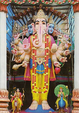
Khairatabad Ganesh is an idol of the Hindu god Ganesha that is installed during the annual festival of Ganesh Chaturthi at Khairatabad locality of Hyderabad, India. Constructed annually and known for its height and the laddu held in the figure's hand, the idol is worshipped during the 10-day festival where thousands of devotees visit every day. On the 11th day, the idol is immersed in the nearby Hussain Sagar lake.

Nallagandla lake is a natural rain-fed lake in the Nallagandla area in the north-western fringe of Hyderabad in the Indian state of Telangana. The lake bed is around 90 acres, that includes permanent marsh on the south-western edge of the lake. The lake bed shares its boundary with the Hyderabad Central University in the east and is surrounded by residential buildings on the remaining sides. The lake bed acreage is under threat from the construction activities around the lake. The plan of the lake as per the survey of GHMC conducted in 2013 can be found here.
Sherechiwadi is a small village located in the state of Maharashtra in western India. It is situated in the Satara district, which is known for its scenic beauty and historical significance. Sherechiwadi is a relatively small village, with a population of approximately 1,200 people.

