
The Kuskokwim River or Kusko River is a river, 702 miles (1,130 km) long, in Southwest Alaska in the United States. It is the ninth largest river in the United States by average discharge volume at its mouth and seventeenth largest by basin drainage area. The Kuskokwim River is the longest river system contained entirely within a single U.S. state.
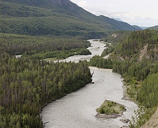
The Matanuska River (Dena'ina: Ch'atanhtnu; Ahtna: Ts'itonhna’) is a 75-mile (121 km) long river in Southcentral Alaska, United States. The river drains a broad valley south of the Alaska Range eponymously known as the Matanuska Valley.

The Karluk River is a stream, 24 miles (39 km) long, on Kodiak Island in the U.S. state of Alaska. It begins at Karluk Lake in the Kodiak National Wildlife Refuge and flows north and then northwest through Karluk Lagoon to the Shelikof Strait at Karluk.

The Selawik River is a stream, 140 miles (230 km) long, in the northwestern part of the U.S. state of Alaska. Originating in the Purcell Mountains near the Zane Hills, it flows generally west through the Selawik National Wildlife Refuge to Selawik Lake, which empties into the Kotzebue Sound in the Chukchi Sea. The river is approximately at the latitude of the Arctic Circle.

Naknek River is a stream, 35 miles (56 km) long, in the Bristol Bay Borough of the U.S. state of Alaska. It flows west from Naknek Lake to empty into Kvichak Bay, an arm of Bristol Bay. The river and lake are both known for their sockeye and other salmon.

The Innoko River (; is a 500-mile tributary of the Yukon River in the U.S. state of Alaska. It flows north from its origin south of Cloudy Mountain in the Kuskokwim Mountains and then southwest to meet the larger river across from Holy Cross.
The Chandalar River is a 100-mile (160 km) tributary of the Yukon River in the U.S. state of Alaska. Its peak flow, recorded by the United States Geological Survey (USGS) between 1964 and 1974 at a stream gauge at Venetie, was 62,800 cubic feet per second (1,780 m3/s) on June 9, 1968.
The Ivishak River is a 95-mile (153 km) tributary of the Sagavanirktok River in the North Slope Borough of the U.S. state of Alaska. Fed by glaciers at the headwaters, the Ivishak flows northeast, then northwest, through the Philip Smith Mountains and the northern foothills of the Arctic National Wildlife Refuge. It enters the Sagavanirktok River on the coastal plain south of Prudhoe Bay.

The Canning River flows through parts of the North Slope in the U.S. state of Alaska. The river begins in the Franklin Mountains of the Brooks Range in the northeastern part of the state. It flows generally north for 125 miles (201 km) through the Arctic National Wildlife Refuge and enters Camden Bay west of Kaktovik on the Beaufort Sea.
The Kokolik River is a stream, 200 miles (320 km) long, in the western North Slope of the U.S. state of Alaska.
The Meade River flows into Admiralty Bay along the North Slope of the U.S. state of Alaska. It begins near Kulugra Ridge in the National Petroleum Reserve–Alaska and flows generally north past Atqasuk to the bay at the southern end of Dease Inlet on the Beaufort Sea.

The Utukok River is a 225-mile (362 km) long stream in the North Slope Borough of the U.S. state of Alaska. It rises in the De Long Mountains at the confluence of Kogruk and Tupik creeks and flows north, northeast, and then northwest. It empties into Kasegaluk Lagoon on the Chukchi Sea of the Arctic Ocean, 20 miles (32 km) southwest of Icy Cape. It is the breeding ground for Arctic Caribou and various birds.
The Etivluk River is a 56-mile (90 km) tributary of the Colville River in the U.S. state of Alaska. A bend in the river about 15 miles (24 km) from the mouth has been identified as one of the most remote locations in mainland Alaska. It is about 120 miles (190 km) from the nearest towns of Ambler to the southwest and Atqasuk to the north and farther from any other settled area in the state.
The Kukpowruk River is a stream, 160 miles (260 km) long, in the western North Slope Borough of the U.S. state of Alaska. It arises in the De Long Mountains of the western Brooks Range and flows north into Kasegaluk Lagoon of the Chukchi Sea, Arctic Ocean. The river mouth is about 9 miles (14 km) south of Point Lay. Arctic Slope Regional Corporation is the major landowner along the river.
The Pitmegea River is a 42-mile (68 km) stream in the western North Slope Borough of the U.S. state of Alaska. From its source in the De Long Mountains, the river flows generally northwest to the Chukchi Sea at Cape Sabine, about 30 miles (48 km) east of Cape Lisburne A prospector who explored the river in 1888 reported its Inuit name as Pitmegeak.
The Kukpuk River is a stream, about 125 miles (201 km) long, in the western North Slope Borough of the U.S. state of Alaska. It flows generally west from the De Long Mountains across the Lisburne Peninsula to Marryat Inlet on the Chukchi Sea. The river mouth is about 12 miles (19 km) northeast of Point Hope.
The Wulik River is a stream, about 80 miles (130 km) long, in the northwestern part of the U.S. state of Alaska. Originating in the De Long Mountains in the North Slope Borough, it flows southwest to Kivalina Lagoon in the Chukchi Sea, east of Kivalina. It heads in the De Long Mountains, which is 5 miles north of Sheep Mountain, and it is 42 miles northwest of Noatak.
The Foraker River is a 60-mile (97 km) stream in central Alaska in the United States. It drains an area on the north slope of the Alaska Range on the south edge of the Tanana Valley southwest of Fairbanks. The Herron River is a major tributary.

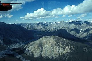
The McKinley River is a 58-mile (93 km) tributary of the Kantishna River in central Alaska in the United States. It drains an area on the north slope of the Alaska Range on the south edge of the Tanana Valley southwest of Fairbanks. The river issues from Muldrow Glacier in the northern Alaska Range in Denali National Park and Preserve, northeast of Denali. It flows through the tundra north of the Alaska Range in a generally northwest direction, joining Birch Creek to form the Kantishna River near Chilchukabena Lake.
The Aichilik River is a river that flows through parts of North Slope Borough in the U.S. state of Alaska. it originates on the northern flank of the Brooks Range and flows north, then northwest to empty into the Beaufort Sea northwest of Demarcation Point.

