
Kristiansand Region is a statistical metropolitan region in the counties of Vest-Agder and Aust-Agder in southern Norway. It is centered on the city of Kristiansand. The region consist of 6 municipalities in the centre of Southern Norway. Vennesla, Songdalen, and Birkenes are inland municipalities while Kristiansand, Søgne, and Lillesand are coastal municipalities. Kristiansand is the largest municipality in population in the region and Birkeland is the largest in area.

Randesund is a village and district within the city of Kristiansand in Vest-Agder county, Norway. The district is located within the borough of Oddernes along the southern coastline between Kvåsefjorden and the Topdalsfjorden and south of the districts of Søm and Hånes. There are several small islands that are just off the coast in Randesund, including Dvergsøya, Randøya, and Herøya, all popular tourists destinations. The village of Randesund is located in the central part of the district and it is the site of Randesund Church. There was a separate municipality of Randesund that existed from 1893 until 1965.
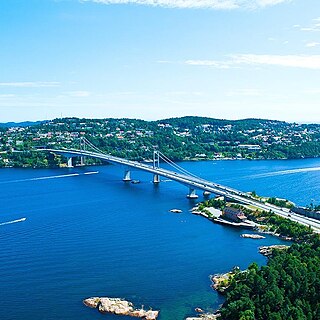
Oddernes is a borough in the municipality of Kristiansand in Vest-Agder county, Norway. The borough covers eastern Kristiansand on the east side of the Topdalsfjorden and the Varodd Bridge. The borough includes the former municipalities of Randesund and Tveit. There was a municipality of Oddernes from 1838 until 1965, but its boundaries were very different from those of the present-day borough.
Agder Police District covers the counties of Aust-Agder and Vest-Agder except Sirdal municipality in Norway, approximately 14,880 square kilometres (5,750 sq mi). The district is headquartered in Kristiansand and consists of seven police stations, Kristiansand, Vågsbygd and Randesund in Kristiansand and in Flekkefjord, Mandal, Grimstad and Arendal, and nineteen sheriff's offices (lensmannskontor). In the police district are approximately 280,000 inhabitants. Agder Police District was established on 1 January 2002 by a merger of the former police districts of Vest-Agder, Kristiansand and Arendal.

Lund is a borough and district in the city of Kristiansand in Vest-Agder county, Norway. It is the second largest borough in the city after Vågsbygd. In 2015, the population was about 30,000. Lund is divided into 4 districts: Lund (centrum), Gimlekollen, Justvik, and Ålefjær.

Hånes is a district in the city of Kristiansand in Vest-Agder county, Norway. It has a population of about 4,000 (2014). Hånes is a part of the borough of Oddernes and it borders the districts of Søm and Randesund to south, the district of Tveit to north, the municipality of Lillesand to east, and the Topdalsfjorden to west. Hånes Church is located in this district.

Søm is a district in the city of Kristiansand in Vest-Agder county, Norway. With a population of about 9,000 (2014), it is the third largest district in Kristiansand. The district is a part of the borough of Oddernes. Søm has borders with the district of Hånes to the north, the district of Randesund to the east and south, and the Topdalsfjorden to the west. Søm is the second most wealthy district in Kristiansand after Lund. Søm Church is located in the district.
Hannevika or Hannevig / Hannevik is a neighbourhood in the city of Kristiansand in Vest-Agder county, Norway. It is located in the borough of Grim and in the district of Tinnheia. The neighborhood is located along the European route E39 highway and the start of Norwegian County Road 456. Hannevika is a large industrial area. Glencore and Hennig-Olsen Iskremfabrikk are the two largest industries located there. Hannevika is located southeast of Eigevannskollen, northeast of Kartheia, and south of Kolsberg.

Koboltveien is a neighbourhood in the city of Kristiansand in Vest-Agder county, Norway. It is located in the borough of Grim and in the district of Tinnheia. It mostly consists of apartments and it is close to the lake Eigevann. The Tinnheia torv neighborhood lies next to Kolboltveien.

Tømmerstø is a neighbourhood in the city of Kristiansand in Vest-Agder county, Norway. It's located in the borough of Oddernes and in the district of Randesund. The neighborhood of Odderhei lies to the northwest, Holte and Frikstad lie to the northeast, and Kongshavn lies to the southeast.

Kartheia is a neighbourhood in the city of Kristiansand in Vest-Agder county, Norway. It is located in the northern part of the borough of Vågsbygd and in the district of Slettheia. The neighborhood lies southwest of the junction of the European route E39 highway and the County Road 456. The district of Hellemyr lies to the north. Kartheia contains residential areas as well as a large industrial area. Gislemyr lies to the south, Trane lies to the west, and Hannevika lies to the east.
Voie is a neighbourhood in the city of Kristiansand in Vest-Agder county, Norway. The neighborhood is located in the borough of Vågsbygd and in the district of Voiebyen. Voie lies along Norwegian County Road 456 and County Road 457. The only road to the island of Andøya goes past the neighborhood of Voie. It lies northwest of Møvik and northeast of Steindalen.

Hannevikåsen is a neighbourhood in the city of Kristiansand in Vest-Agder county, Norway. It is located in the borough of Grim and in the district of Tinnheia. It lies up the hill from Hannevika and Kolsdalen. The European route E39 highway runs underneath the south end of the neighborhood.
Frikstad is a neighbourhood in the city of Kristiansand in Vest-Agder county, Norway. It's located in the borough of Oddernes and in the district of Randesund. Randesund Church is located at Frikstad. The neighborhoods of Holte and Tømmerstø lie to the southwest and the neighborhood of Kongshavn lies to the southeast.

Odderhei is a neighbourhood in the city of Kristiansand in Vest-Agder county, Norway. It's located in the borough of Oddernes and in the district of Randesund. The neighborhood is located northwest of Tømmerstø and Holte. The nearby district of Søm lies to the north.
Holte is a neighbourhood in the city of Kristiansand in Vest-Agder county, Norway. It's located in the borough of Oddernes and in the district of Randesund. The neighborhood of Tømmerstø lies to the south and Frikstad lies to the east. Holte Junior High is the only junior high in Randesund.
Kroodden is a neighbourhood in the city of Kristiansand in Vest-Agder county, Norway. The neighborhood is located in the borough of Vågsbygd and in the district of Voiebyen. The Kristiansand Cannon Museum is located to the west of Kroodden. Kroodden is south of Spinneren along the coast. From Kroodden, the Flekkerøy Tunnel leads across the strait to the island of Flekkerøy.
Voieåsen is a neighbourhood in the city of Kristiansand in Vest-Agder county, Norway. The neighborhood is located in the borough of Vågsbygd and in the district of Voiebyen. Voieåsen is north of Møviklia, south of Voie, east of Voielia, and west of Møvik.

Randesund is a former municipality in Vest-Agder county, Norway. The municipality existed from 1893 until its dissolution in 1965. The administrative centre was the village of Randesund where Randesund Church is located. The municipality was located in the southeastern part of the present-day municipality of Kristiansand, east of the Topdalsfjorden and south of the old municipality of Tveit. Since 1965, the area of Randesund has been the district of Randesund within the city of Kristiansand.
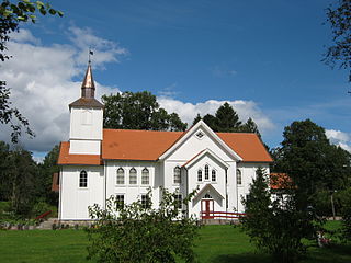
Randesund Church is a parish church in Kristiansand municipality in Vest-Agder county, Norway. It is located in the Frikstad neighborhood in the Randesund district in the borough of Oddernes inside the city of Kristiansand. The church is part of the Randesund parish in the Kristiansand arch-deanery in the Diocese of Agder og Telemark. The white, wooden, cruciform church was built in 1864 using plans by the architect Christian Heinrich Grosch. The church seats about 450 people. It was consecrated on 28 October 1864 by the Bishop Jacob von der Lippe.


