Kongwa District

Last updated
Kongwa District
Kongwa District in Dodoma 2022.svg
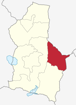
Kongwa District of Dodoma Region.
Coordinates: 06°11′34″S36°24′26″E / 6.19278°S 36.40722°E / -6.19278; 36.40722
CountryFlag of Tanzania.svg  Tanzania
Region Dodoma Region
Area
  Total3,958 km2 (1,528 sq mi)
Population
 (2022 census)
  Total443,867
  Density110/km2 (290/sq mi)

Kongwa District is one of the seven districts of the Dodoma Region of Tanzania. It is bordered to the north by Manyara Region, to the east by Morogoro Region, to the south by Mpwapwa District, and to the west by Chamwino District. Its district capital is the town of Kongwa.

Contents

According to the 2012 Tanzania National Census, the population of Kongwa District was 309,973, [1] up from 249,760 in the 2002 Census. [2] By 2022, the population had grown to 443,867. [3]


Transport

Paved trunk road T3 from Morogoro to Dodoma passes through the district. [4]

Administrative subdivisions

As of 2012, Kongwa District was administratively divided into 22 wards. [1]

Wards

See also

Related Research Articles

<span class="mw-page-title-main">Dodoma Region</span> Region of Tanzania

Dodoma Region is one of Tanzania's 31 administrative regions. The regional capital is the city of Dodoma. The region is located in central Tanzania, it is bordered by Singida Region to the west; Manyara Region to the north; Iringa Region to the south; and Morogoro Region to the east. Dodoma Region hosts the nation's capital city with where the legislative assembly or Bunge is based. Dodoma Region also hosts one of the largest University in Tanzania, University of Dodoma. The region is sole home of the Tanzanian wine industry, which is the second largest wine industry on the continent after South Africa. According to the 2022 national census, the region had a population of 3,085,625. 2012 national census, where by, 2012 had 2,083,588.

Mpwapwa is a market town, in the Dodoma Region of Tanzania. It is the district capital of Mpwapwa District. According to the 2012 Tanzania National Census, the population of Mpwapwa was 21,337.

<span class="mw-page-title-main">Manyara Region</span> Region of Tanzania

Manyara Region is one of Tanzania's 31 administrative regions. The regional capital is the town of Babati. According to the 2012 national census, the region had a population of 1,425,131, which was lower than the pre-census projection of 1,497,555. For 2002–2012, the region's 3.2 percent average annual population growth rate was tied for the third highest in the country. It was also the 22nd most densely populated region with 32 people per square kilometre.

<span class="mw-page-title-main">Iringa Region</span> Region of Tanzania

Iringa Region is one of Tanzania's 31 administrative regions. The region covers an area of 35,503 km2 (13,708 sq mi). The region is comparable in size to the combined land area of the nation state of Guinea Bissau. Iringa Region is bordered to the east by Morogoro Region and south by Njombe Region. On the west the region is bordered by Mbeya Region. Dodoma Region and Singida Region border Iringa on the north. The regional capital is the city Iringa for which the city is named after. According to the 2022 census, the region has a total population of 1,192,728. Iringa Region is home to Ruaha National Park, Tanzania's second national largest park.

<span class="mw-page-title-main">Biharamulo District</span> District in Kagera Region, Tanzania

Biharamulo District is one of the eight districts of the Kagera Region of Tanzania. It is bordered to the north by Karagwe District and Muleba District, to the east and south by Geita Region, to the west by Ngara District, and to the southwest by the Kigoma Region. Its administrative seat is Biharamulo town. Biharamulo Game Reserve is located within the borders of the district.

<span class="mw-page-title-main">Manyoni District</span> District in Singida Region, Tanzania

Manyoni District is one of the six districts in the Singida Region of Tanzania. The district capital is the town of Manyoni. The district is bordered to the north by the Ikungi District, to the east by the Dodoma Region, to the south by the Iringa Region, to the southwest by the Mbeya Region and to the west by the Tabora Region. In 2015 the Itigi District was created from the Manyoni District, separating the Itigi Division that was the large portion of the south western of the district.

Makutupora is an administrative ward in the Dodoma Urban district of the Dodoma Region of Tanzania. In 2016 the Tanzania National Bureau of Statistics report there were 15,683 people in the ward, from 14,430 in 2012.

Bahi is town and an administrative ward in the Dodoma Region of Tanzania. It is the district capital of Bahi District.

<span class="mw-page-title-main">Kondoa District</span> District in Dodoma Region, Tanzania

Kondoa District is one of the seven districts of the Dodoma Region of Tanzania. It is bordered to the north by Manyara Region, and to the south by Chemba District. Its district capital is the town of Kondoa.

<span class="mw-page-title-main">Mpwapwa District</span> District in Dodoma Region, Tanzania

Mpwapwa District is one of the seven districts of the Dodoma Region of Tanzania. It is bordered to the north by Kongwa District, to the east by Morogoro Region, to the south by Iringa Region, and to the west by Chamwino District. Its district capital is the town of Mpwapwa.

Iduo is an administrative ward in the Kongwa district of the Dodoma Region of Tanzania. In 2016 the Tanzania National Bureau of Statistics report there were 12,169 people in the ward, from 11,197 in 2012.

Kibaigwa is an administrative ward in the Kongwa District of the Dodoma Region of Tanzania. In 2016 the Tanzania National Bureau of Statistics report there were 26,911 people in the ward, from 24,761 in 2012.

Kongwa is a town and an administrative ward in the Kongwa District of the Dodoma Region of Tanzania. According to the 2012 census, the ward has a total population of 13,531, with an average household size of 4.6.

Mkoka is an administrative ward in the Kongwa District of the Dodoma Region of Tanzania. In 2016 the Tanzania National Bureau of Statistics report there were 12,960 people in the ward, from 11,925 in 2012.

Mtanana is an administrative ward in the Kongwa District of the Dodoma Region of Tanzania. In 2016 the Tanzania National Bureau of Statistics report there were 13,650 people in the ward, from 12,559 in 2012.

Pandambili is an administrative ward in the Kongwa District of the Dodoma Region of Tanzania. In 2016 the Tanzania National Bureau of Statistics report there were 8,699 people in the ward, from 8,004 in 2012.

Ugogoni is an administrative ward in the Kongwa District of the Dodoma Region of Tanzania. In 2016 the Tanzania National Bureau of Statistics report there were 18,528 people in the ward, from 17,048 in 2012.

<span class="mw-page-title-main">Bukoba Urban District</span> District in Kagera Region, Tanzania

Bukoba Urban District is one of the eight districts of the Kagera Region of Tanzania. It is bordered to east by Lake Victoria and to the west by Bukoba Rural District. Its administrative seat is the town of Bukoba.

<span class="mw-page-title-main">Bahi District</span> District in Dodoma Region, Tanzania

Bahi District is one of the seven districts of the Dodoma Region of Tanzania. Bahi District is bordered to the north by Chemba District, to the east by Dodoma District and Chamwino District, and to the west by Singida Region. Its administrative seat is the town of Bahi.

<span class="mw-page-title-main">Chamwino District, Dodoma</span> District in Dodoma Region, Tanzania

Chamwino District is one of the seven districts of the Dodoma Region of Tanzania. It is bordered to the north by Chemba District, to the east by Manyara Region, Kongwa District and Mpwapwa District, to the south by Iringa Region, and to the west by Singida Region, Bahi District and Dodoma District. Its administrative seat is the town of Chamwino.

References

  1. 1 2 "Census 2012". National Bureau of Statistics. Retrieved 21 July 2016.
  2. "2002 Population and Housing Census General Report". Government of Tanzania. Archived from the original on 18 March 2004.
  3. "Tanzania: Administrative Division (Regions and Districts) - Population Statistics, Charts and Map". www.citypopulation.de. Retrieved 2024-02-10.
  4. "Dodoma Roads Network" (PDF). Tanroads. Archived from the original (PDF) on 24 June 2016. Retrieved 17 June 2016.