
Kołobrzeg is a port and spa city in the West Pomeranian Voivodeship in north-western Poland with about 47,000 inhabitants. Kołobrzeg is located on the Parsęta River on the south coast of the Baltic Sea. It is the capital of Kołobrzeg County.

Cape Arkona is a 45-metre (150-foot) high cape on the island of Rügen in Mecklenburg-Vorpommern, Germany. It forms the tip of the Wittow peninsula, just a few kilometres north of the Jasmund National Park. The protected landscape of Cape Arkona, together with the fishing village of Vitt, belongs to the municipality of Putgarten and is one of the most popular tourist destinations on Rügen, receiving about 800,000 visitors annually.

The Bay of Greifswald or Greifswald Bodden is a basin in the southwestern Baltic Sea, off the shores of Germany in the state of Mecklenburg-Vorpommern. With an area of 514 km², it is the largest Bodden of the German Baltic coast.

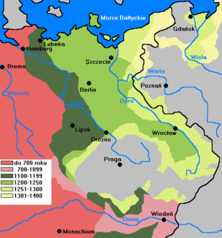
The history of Pomerania starts shortly before 1000 AD, with ongoing conquests by newly arrived Polan rulers. Before that, the area was recorded nearly 2000 years ago as Germania, and in modern times Pomerania has been split between Germany and Poland. Its name comes from the Old Polish po more, which means "(land) at the sea".
Wolgast is a town in the district of Vorpommern-Greifswald, in Mecklenburg-Vorpommern, Germany. It is situated on the bank of the river Peenestrom, vis-a-vis the island of Usedom on the Baltic coast that can be accessed by road and railway via a movable bascule bridge. In December 2004, the town had a population of 12,725.

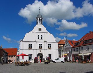
Wolin is a town in northwestern Poland, situated on the southern tip of the Wolin island off the Baltic coast of the historic region of Western Pomerania. The island lies at the edge of the strait of Dziwna in Kamień County, West Pomeranian Voivodeship.
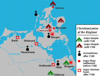
The Rani or Rujani were a West Slavic tribe based on the island of Rugia (Rügen) and the southwestern mainland across the Strelasund in what is today northeastern Germany.

The Reichsuniversität Straßburg was founded in 1941 by the Nazis in Alsace after the annexation of Alsace-Lorraine by Nazi Germany. The University of Strasbourg had moved to Clermont-Ferrand in 1939. The university's purpose was to restore the German character of the Kaiser-Wilhelm-Universität, as the University of Strasbourg was named from 1872 to 1918, and to advance "German knowledge" in the annexed territory. When the Allies arrived in Alsace in 1944, the Reichsuniversität was first transferred to Tübingen and then dissolved.

Eldena Abbey, originally Hilda Abbey is a former Cistercian monastery near the present town of Greifswald in Mecklenburg-Vorpommern, Germany. Only ruins survive, which are well known as a frequent subject of Caspar David Friedrich's paintings, including the famous Abtei im Eichwald.
Pomerania during the Early Middle Ages covers the History of Pomerania from the 7th to the 11th centuries.
After the glaciers of the Ice Age in the Early Stone Age withdrew from the area, which since about 1000 AD is called Pomerania, in what are now northern Germany and Poland, they left a tundra. First humans appeared, hunting reindeer in the summer. A climate change in 8000 BC allowed hunters and foragers of the Ertebølle-Ellerbek culture to continuously inhabit the area. These people became influenced by farmers of the Linear Pottery culture who settled in southern Pomerania. The hunters of the Ertebølle-Ellerbek culture became farmers of the Funnelbeaker culture in 3000 BC. The Havelland culture dominated in the Uckermark from 2500 to 2000 BC. In 2400 BC, the Corded Ware culture reached Pomerania and introduced the domestic horse. Both Linear Pottery and Corded Ware culture have been associated with Indo-Europeans. Except for Western Pomerania, the Funnelbeaker culture was replaced by the Globular Amphora culture a thousand years later.
Dierkow near Rostock, Mecklenburg, was a Viking Age Slavic-Scandinavian settlement at the southern Baltic coast in the late 8th and early 9th century. Neither the site itself, nor the adjacent Slavic burghs Kessin and Fresendorf have yet been sufficiently researched.
Germania Slavica is a historiographic term used since the 1950s to denote the landscape of the medieval language border zone between Germanic people and Slavs in Central Europe on the one hand and a 20th-century scientific working group to research the conditions in that area during the Early Middle Ages and High Middle Ages on the other.

Riems is an island in the southwestern part of the Bay of Greifswald, a broad, shallow embayment of the Baltic Sea between the German mainland and the island of Rügen. Riems belongs administratively to the urban district of Greifswald, but is an exclave. Riemserort is municipally part of Riems, but lies opposite the island on the mainland.

The Jaromarsburg was a cult site for the Slavic tribe of Rani dedicated to the god Svantovit and used from the 9th to the 12th century. It was located on the northeastern tip of the Baltic Sea island of Rügen at Cape Arkona, and was protected on two sides by the cliffed coast and from the land side by a Slavic burgwall.

Michael Matheus is a German historian.
Dirk Alvermann was a German historian and archivist.
Sebastian Brather is a German medieval archaeologist and co-editor of Germanische Altertumskunde Online.

Thomas Straubhaar is a Swiss economist and migration researcher. He is a professor for international economic relations at the University of Hamburg.

Mistislaw, also known as Mstislav, was an Elbe Slavic prince of the Nakonid lineage and ruled over the Obotrites in what is now Mecklenburg and eastern Holstein from 990/995 to 1018.


