
Mecklenburg-Vorpommern ; also known by its anglicized name Mecklenburg–Western Pomerania, is a state in the north-east of Germany. Of the country's sixteen states, Mecklenburg-Vorpommern ranks 14th in population; it covers an area of 23,213 km2 (8,963 sq mi), making it the sixth largest German state in area; and it is 16th in population density. Schwerin is the state capital and Rostock is the largest city. Other major cities include Neubrandenburg, Stralsund, Greifswald, Wismar, and Güstrow. It was named after the two regions of Mecklenburg and Vorpommern, and its name means the "nearer part of Pomerania", with the rest now lying in Poland.
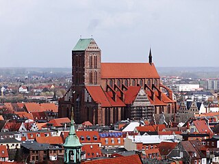
Wismar, officially the Hanseatic City of Wismar is, with around 43,000 inhabitants, the sixth-largest city of the northeastern German state of Mecklenburg-Vorpommern, and the fourth-largest city of Mecklenburg after Rostock, Schwerin and Neubrandenburg. The city was the third-largest port city in former East Germany after Rostock and Stralsund.
Nordwestmecklenburg is a Kreis (district) in the north-western part of Mecklenburg-Vorpommern, Germany. It is situated on the coast of the Baltic Sea and borders on Schleswig-Holstein to the west. Neighboring districts are Rostock, Ludwigslust-Parchim and the district-free city Schwerin, and the district Lauenburg and the district-free city Lübeck in Schleswig-Holstein. The district seat is the town Wismar.
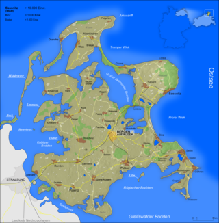
Rügen is Germany's largest island. It is located off the Pomeranian coast in the Baltic Sea and belongs to the state of Mecklenburg-Western Pomerania.

The Western Pomerania Lagoon Area National Park is Mecklenburg-Vorpommern's largest national park, situated at the coast of the Baltic Sea. It consists of several peninsulas, islands and lagoon shore areas in the Baltic Sea, belonging to the district of Vorpommern-Rügen.

New Britain is the largest island in the Bismarck Archipelago, part of the Islands Region of Papua New Guinea. It is separated from New Guinea by a northwest corner of the Solomon Sea and from New Ireland by St. George's Channel. The main towns of New Britain are Rabaul/Kokopo and Kimbe. The island is roughly the size of Taiwan. When the island was part of German New Guinea, its name was Neupommern . In common with most of the Bismarcks it was largely formed by volcanic processes, and has active volcanoes including Ulawun, Langila, the Garbuna Group, the Sulu Range, and the volcanoes Tavurvur and Vulcan of the Rabaul caldera. A major eruption of Tavurvur in 1994 destroyed the East New Britain provincial capital of Rabaul. Most of the town still lies under metres of ash, and the capital has been moved to nearby Kokopo.

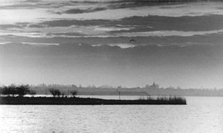
Poel or Poel Island, is an island in the Baltic Sea. It forms the natural northern and eastern boundaries of the Bay of Wismar on the German coast. The northern coast of the island is also on the south side of the large gulf known as the Bay of Mecklenburg, which Wismar Bay enters into. Insel Poel thus forms on its northern side the unofficial latitude of the northern boundary of the Wismar Bay.

The Bay of Mecklenburg, also known as the Mecklenburg Bay or Mecklenburg Bight, is a long narrow basin making up the southwestern finger-like arm of the Baltic Sea, between the shores of Germany to the south and the Danish islands of Lolland, Falster, and Møn to the north, the shores of Jutland to the west, and joining the largest part of the Baltic to the east.

Walfisch is an uninhabited German island, in the Bay of Mecklenburg in the Baltic Sea. It lies approximately 4.5 kilometres (2.8 mi) north of the city of Wismar, south of the island of Poel. The island is very flat and has a maximum circumference of about 500 by 300 metres, a surface area of 20 hectares and is a nature reserve.
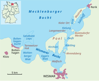
The Bay of Wismar or more commonly Wismar Bay or Wismarbucht is a well sheltered multi-sectioned bay in the southwestern Baltic Sea, in Mecklenburg-Vorpommern, Germany, and is considered the south-central part of the much larger arm of the Baltic known as the Mecklenburg Bay —a long fingerlike gulf oriented to the west-southwest (WSW) from the (central) Baltic proper. Wismar bay is considered one of the finest natural harbors on the Baltic, and served as the destination for much seaborne shipping until circa the 1910s when its minimum depths of 5 meters (16 ft) became too shallow for larger more modern ships. Today, because of the shallow sheltered waters the bay is the subject of much research via underwater archeology
Despite its name, the Dassower See , sometimes called Lake Dassow or Dassow Bay in English, is not a lake, but a side bay, locally known as a wiek, of the Trave Fjord, northeast of Lübeck (Schleswig-Holstein) on the Baltic Sea.

Bodden are briny bodies of water often forming lagoons, along the southwestern shores of the Baltic Sea, primarily in Germany's state of Mecklenburg-Vorpommern. These lagoons can be found especially around the island of Rügen, Usedom and the Fischland-Darss-Zingst peninsula. Some of them are protected reserves, forming the Western Pomerania Lagoon Area National Park.
The Klützer Winkel or Klützer Ort is a part of the Nordwestmecklenburg district, in Mecklenburg-Western Pomerania, Germany. It is in the western part of the district on the Baltic Sea between the Hanseatic towns of Lübeck (Priwall) and Wismar, north of Grevesmühlen and centred on Klütz. The hilly landscape of the Klützer Winkel was formed during the last ice age. Its highest points are the Hohe Schönberg, at 89 metres above mean sea level, and the Heideberg. The Klützer Winkel may also be considered a peninsula between the Bay of Lübeck and Bay of Mecklenburg, because from a line between the Dassower See and Wohlenberger Wiek it extends up to 10 km to the north. The area has a number of tourist attractions such as the Baltic Sea cliffs, the spa resort of Boltenhagen, the town of Klütz with its castle, Schloss Bothmer, and the railway museum as well as various other castles such as the castle of Gross-Schwansee, today a luxury hotel.
West Mecklenburg is the western part of the German federal state of Mecklenburg-Vorpommern, covering an area of ca. 7,000 km². It incorporates parts of the historic territories of Mecklenburg-Schwerin and Mecklenburg-Strelitz and of Saxe-Lauenburg.

Kleiner Werder is the name of an island and its associated group of uninhabited and not clearly geographically separable German islands in the Baltic Sea that belong to the state of Mecklenburg-Western Pomerania.
The Breitling is a narrow strait in the Baltic Sea between the island of Poel and the mainland in the northeast of the district of Nordwestmecklenburg. It links the sheltered part of the Bay of Wismar, beginning south of Poeldamm, with the Salzhaff.

Swedish Wismar was a Dominion under the Swedish Crown from 1648 to 1903 and corresponded roughly to the modern boundaries of the city of Wismar. The former Hanseatic city lies on the Baltic coast of modern-day Germany.
Baumwerder is an uninhabited island, approximately 2 hectares in area, in the Breitling facing a bay. It belongs to the municipality of Blowatz.

Böhmke is a small, uninhabited island that lies between the lakes of Nepperminer See and Balmer See in the southeastern part of the Achterwasser, which separates the large Baltic Sea island Usedom from the mainland of Germany and Poland. The island belongs to the municipality of Benz in the county of Vorpommern-Greifswald, in the Germany state of Mecklenburg-Western Pomerania.
Weidenschwanz is an uninhabited island, approximately 440 square metres in area, in the Breitling between the Mecklenburg mainland and the island of Poel. It belongs to the municipality of Blowatz.

