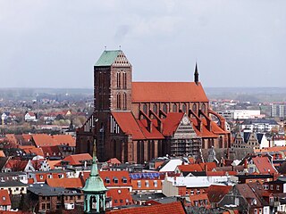
Wismar, officially the Hanseatic City of Wismar is, with around 43,000 inhabitants, the sixth-largest city of the northeastern German state of Mecklenburg-Vorpommern, and the fourth-largest city of Mecklenburg after Rostock, Schwerin and Neubrandenburg. The city was the third-largest port city in former East Germany after Rostock and Stralsund.

The common shelduck is a waterfowl species of the shelduck genus, Tadorna. It is widespread and common in the Euro-Siberian region of the Palearctic, mainly breeding in temperate and wintering in subtropical regions; in winter, it can also be found in the Maghreb.

Poel or Poel Island, is an island in the Baltic Sea. It forms the natural northern and eastern boundaries of the Bay of Wismar on the German coast. The northern coast of the island is also on the south side of the large gulf known as the Bay of Mecklenburg, which Wismar Bay enters into. Insel Poel thus forms on its northern side the unofficial latitude of the northern boundary of the Wismar Bay.

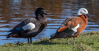
The ruddy shelduck, known in India as the Brahminy duck, is a member of the family Anatidae. It is a distinctive waterfowl, 58 to 70 cm in length with a wingspan of 110 to 135 cm. It has orange-brown body plumage with a paler head, while the tail and the flight feathers in the wings are black, contrasting with the white wing-coverts. It is a migratory bird, wintering in the Indian subcontinent and breeding in southeastern Europe and central Asia, though there are small resident populations in North Africa. It has a loud honking call.

Brisbane Water is a wave-dominated barrier estuary located in the Central Coast region of New South Wales, Australia. Brisbane Water has its origin at the confluence of the Narara and Coorumbine Creeks, to the south–east of Gosford and travels for approximately 18 kilometres (11 mi) in a southerly direction to its mouth at Broken Bay, about 7 kilometres (4.3 mi) from the Tasman Sea, at Barrenjoey Head. A number of towns and suburbs surround the shores of Brisbane Water, including Blackwall, Booker Bay, Davistown, Empire Bay, Erina, Ettalong Beach, Gosford, Green Point, Hardys Bay, Kilcare, Kincumber, Koolewong, Phegans Bay, Point Frederick, Point Clare, Saratoga, Tascott, Wagstaffe, and Woy Woy. Contained within Brisbane Water is St Huberts Island, Rileys Island, Dunmar Island and Pelican Island; and adjoining the estuary is Brisbane Water National Park to the west and Bouddi National Park to the east. Forming part of the same tidal estuary system is a separate but connected basin, the Kincumber Broadwater, lying to the east of Davistown.
The paradise shelduck, also known as the paradise duck, or pūtangitangi in Māori, is a species of shelduck, a group of goose-like ducks, which is endemic to New Zealand. Johann Friedrich Gmelin placed it in the genus Anas with the ducks, geese, and swans. Both the male and female have striking plumages: the male has a black head and barred black body and the female has a white head with a chestnut body. They weigh between 1.09 and 2 kg and are between 63 and 71 cm in length.

Linden is the second largest city in Guyana after Georgetown, and capital of the Upper Demerara-Berbice region, located at 6°0′0″N58°18′0″W, altitude 48 m (160 ft). It was declared a town in 1970, and includes the communities of MacKenzie, Christianburg, and Wismar. It lies on the Demerara River and has a population of 27,277 as of 2012. It is primarily a bauxite mining town, containing many mines 60–90 m deep, with many other pits now in disuse.

The Ythan Estuary is the tidal component of the Ythan River, emptying into the North Sea 19 kilometres (12 mi) north of Aberdeen, Scotland. The estuary’s tidal action extends a 7 kilometres (4.3 mi) inland and has characteristic widths of between 250 metres (820 ft) and 780 metres (2,560 ft). Besides the tidal channel there are interfaces to the upland dunes including mudflats, sand beaches and shingle flats. Reaches of salt marsh occur, but they are primarily near the Waterside Bridge and the mouth of the Tarty Burn, a small tributary river. Based upon the habitat of the moorland bordering the east of the Ythan River near the mouth, this estuary is the most significant coastal moorland in the northern United Kingdom.

Walfisch is an uninhabited German island, in the Bay of Mecklenburg in the Baltic Sea. It lies approximately 4.5 kilometres (2.8 mi) north of the city of Wismar, south of the island of Poel. The island is very flat and has a maximum circumference of about 500 by 300 metres, a surface area of 20 hectares and is a nature reserve.
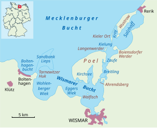
The Bay of Wismar or more commonly Wismar Bay or Wismarbucht is a well sheltered multi-sectioned bay in the southwestern Baltic Sea, in Mecklenburg-Vorpommern, Germany, and is considered the south-central part of the much larger arm of the Baltic known as the Mecklenburg Bay —a long fingerlike gulf oriented to the west-southwest (WSW) from the (central) Baltic proper. Wismar bay is considered one of the finest natural harbors on the Baltic, and served as the destination for much seaborne shipping until circa the 1910s when its minimum depths of 5 meters (16 ft) became too shallow for larger more modern ships. Today, because of the shallow sheltered waters the bay is the subject of much research via underwater archeology

Chantry Island is a small island in Lake Huron, south of the mouth of the Saugeen River and approximately a kilometre off the shores of the town of Southampton, Ontario. It is approximately 19 hectares in size and is a migratory bird sanctuary. Since the sanctuary territory extends 183 metres into the water surrounding the island, the total official area is listed as 63 hectares.
Coffin Island is an island that is located in the Great Southern region of Western Australia. The island is 300 metres (984 ft) offshore from Two Peoples Bay Nature Reserve and the island is also a protected area making up part of the reserve. With an area of 28 hectares the island is made up mostly of granite.
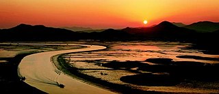
Suncheon Bay Ecological Park is a protected natural area near Suncheon, South Korea. It is a bay between Yeosu and Goheung peninsulas, located 8 km (5.0 mi) from the center of Suncheon, with 21.6 km2 (8.3 sq mi) of mudflats and 5.4 km2 (2.1 sq mi) of reed beds.

Mühlenteich is a lake in Wismar, Mecklenburg-Vorpommern, Germany. Its elevation is 4 m (13 ft) and its surface area is 0.482 km2 (0.186 sq mi). The water body is highly indented. There is a prominent southern bay with two smaller islands and a distinct northern bay. The Mühlenteich has a north-south extension of about 1700 metres and a west-east extension of about 400 metres. Large parts of the pond shore, especially in the south, are marshy and mostly silted up. The Wallenstein Ditch, which is dammed in the pond, flows into it in the southwest and leaves it again in the north. In addition, the Mühlenbach flows off in the west through the inner city towards the Baltic Sea. Another tributary is a ditch from the south-east. The south-western part of the water body belongs to the nature reserve Teichgebiet Wismar-Kluß. The pond is used for commercial trout farming.

Ardley Island is an island 1.9 kilometres (1 nmi) long, lying in Maxwell Bay close off the south-west end of King George Island, in the South Shetland Islands of Antarctica. It was charted as a peninsula in 1935 by Discovery Investigations personnel of the Discovery II and named for Lieutenant R.A.B. Ardley, Royal Naval Reserve, an officer on the ship in 1929–31 and 1931–33. Aerial photography has since shown that the feature is an island with Braillard Point being the headland forming the northeast end of Ardley Island. It has been designated an Antarctic Specially Protected Area because of the importance of its seabird colonies.
The Breitling is a narrow strait in the Baltic Sea between the island of Poel and the mainland in the northeast of the district of Nordwestmecklenburg. It links the sheltered part of the Bay of Wismar, beginning south of Poeldamm, with the Salzhaff.

Ahrendsberg is an uninhabited island, 8.6 hectares in area, near the island of Poel in the Breitling, a strait off the Bay of Wismar on the Baltic coast of Germany.

The Étang d'Urbino is a coastal lagoon beside the Tyrrhenian Sea in the Haute-Corse department on the French island of Corsica.
Grot Deil is an uninhabited Baltic Sea island in the Breitling between the mainland of Mecklenburg and the island of Poel. It has an area of approximately 0.17 hectares and belongs to the municipality of Blowatz.
Weidenschwanz is an uninhabited island, approximately 440 square metres in area, in the Breitling between the Mecklenburg mainland and the island of Poel. It belongs to the municipality of Blowatz.

