Buena Vista is a village in the Canadian province of Saskatchewan within the Rural Municipality of Lumsden No. 189 and Census Division No. 6. The village is located 40 km (25 mi) north-west of Regina, on the southern shore of Last Mountain Lake just off Highway 54. It is bounded to the west by Regina Beach, demarcated by 16 Street.
Milden is a village in the Canadian province of Saskatchewan within the Rural Municipality of Milden No. 286 and Census Division No. 12. The village is located at the junction of Highway 15 and Highway 655 approximately 20 km west of Outlook on Highway 15.
Atwater is a village in the Canadian province of Saskatchewan within the Rural Municipality of Fertile Belt No. 183 and Census Division No. 5. The village is approximately 45 kilometres (28 mi) southeast of the city of Melville on Highway 629.

Pangman is a village in the Canadian province of Saskatchewan within the Rural Municipality of Norton No. 69 and Census Division No. 2. Formerly known as West Calder, it is south of the city of Regina.

The Rural Municipality of Storthoaks No. 31 is a rural municipality (RM) in the Canadian province of Saskatchewan within Census Division No. 1 and SARM Division No. 1.
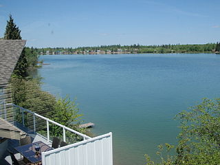
Crystal Lake is an organized hamlet within the Rural Municipality (RM) of Keys No. 303 in the Canadian province of Saskatchewan. It is also recognized as part of a designated place by Statistics Canada. The organized hamlet is on the majority of the shores of Crystal Lake, 1.0 km (0.62 mi) west of Highway 9 and approximately 70 km (43 mi) north of the City of Yorkton. The second part of the designated place is on the balance of the shores of Crystal Lake within the adjacent RM of Buchanan No. 304.
Storthoaks is a village in the Canadian province of Saskatchewan within the Rural Municipality of Storthoaks No. 31 and Census Division No. 1. The village is located approximately 129 km east of the City of Estevan on Highway 361 and 16 km west of the Saskatchewan-Manitoba border.

Disley is a village in the Canadian province of Saskatchewan within the Rural Municipality of Lumsden No. 189 and Census Division No. 6. It is located 18 km (11 mi) west of Lumsden just south of the Louis Riel Trail and 48 kilometres northwest of the City of Regina.
Dubuc is a village in the Canadian province of Saskatchewan within the Rural Municipality of Grayson No. 184 and Census Division No. 5. The village is located 55 kilometres south of the City of Yorkton and 30 km west of Esterhazy.
Duff is a special service area in the Canadian province of Saskatchewan within the Rural Municipality (RM) of Stanley No. 215 and Census Division No. 5. It is approximately 122 kilometres (76 mi) northeast of the City of Regina, 66 kilometres (41 mi) southwest of Yorkton and 20 kilometres (12 mi) west of Melville.
Hubbard is a village in the Canadian province of Saskatchewan within the Rural Municipality of Ituna Bon Accord No. 246 and Census Division No. 10.

Invermay is a village in the Canadian province of Saskatchewan within the Rural Municipality of Invermay No. 305 and Census Division No. 9. Invermay is about 50 km west of Canora or about 50 km east of Wadena on Highway 5.
Webb is a village in the Canadian province of Saskatchewan within the Rural Municipality of Webb No. 138 and Census Division No. 8.
Plunkett is a special service area in the Canadian province of Saskatchewan within the Rural Municipality of Viscount No. 341 and Census Division No. 11. It held village status between 1921 and 2022.
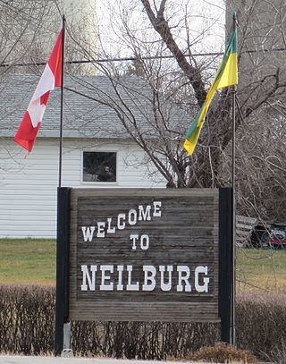
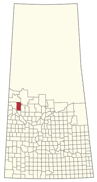
Neilburg is a village in the Canadian province of Saskatchewan within the Rural Municipality of Hillsdale No. 440 and Census Division No. 13. A grade K–12 school is located in the village that services the Neilburg area as well as grade 7–12 students from Marsden.
Ruddell is a village in the Canadian province of Saskatchewan within the Rural Municipality of Mayfield No. 406 and Census Division No. 16. The village is located on Highway 16, approximately 37 km (23 mi) east of the City of North Battleford and 102 km west of the City of Saskatoon. Ruddell post office first opened in 1906.

Viscount is a village in the Canadian province of Saskatchewan within the Rural Municipality of Viscount No. 341 and Census Division No. 11. Viscount is located on Saskatchewan Highway 16, the Yellowhead Highway, in central Saskatchewan east of Colonsay and west of Lanigan. As of the Canada 2016 Census, Viscount had a population of 232.

Sheho is a village in the Canadian province of Saskatchewan within the Rural Municipality of Insinger No. 275 and Census Division No. 9. Sheho is located on Saskatchewan Highway 16, in southeast Saskatchewan between Foam Lake to the west and the City of Yorkton to the east. Sheho Lake post office first opened in 1891 at the legal land description of Sec.28, Twp.30, R.9, W2 before moving slightly and changing name to Sheho.
Waseca is a village in the Canadian province of Saskatchewan within the Rural Municipality of Eldon No. 471 and Census Division No. 17. Waseca is located on Highway 16, the Yellowhead Highway, in northwest Saskatchewan. Waseca is located east of Lashburn and west of Maidstone.
The Rural Municipality of Mervin No. 499 is a rural municipality (RM) in the Canadian province of Saskatchewan within Census Division No. 17 and SARM Division No. 6.

