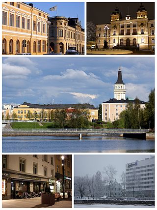
Oulu is a city, municipality and a seaside resort of about 210,000 inhabitants in the region of North Ostrobothnia, Finland. It is the most populous city in northern Finland and the fifth most populous in the country after: Helsinki, Espoo, Tampere and Vantaa, and the fourth largest urban area in the country after Helsinki, Tampere and Turku. Oulu's neighbouring municipalities are: Hailuoto, Ii, Kempele, Liminka, Lumijoki, Muhos, Pudasjärvi, Tyrnävä and Utajärvi.

Oulu Castle was a late defense castle in Oulu, Finland. It was built on an island in the delta of Oulu River in 1590. The castle was mostly made of wood and earth walls. There probably was an earlier medieval castle on the same site latest by 1375. The Russian Sophia Chronicle has recorded that men from Novgorod tried to conquer a new castle in the Oulu River delta in 1377 but were unsuccessful.
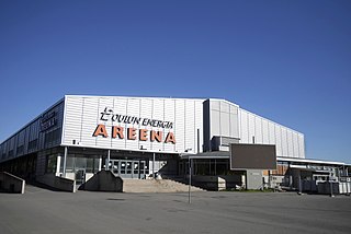
Oulun jäähalli, previously known as Raksilan jäähalli and called Oulun Energia Areena since 2006 for sponsorship reasons, is an ice sport arena in the Raksila Sports Centre, located in the Raksila district of Oulu, Finland. It is operated by the City of Oulu. The arena is best known as an ice hockey venue and the home of Liiga team Oulun Kärpät.

Tuira is a district of the city of Oulu, Finland. It is located north of city centre across the Oulujoki River. After the first bridges over Oulujoki connecting Tuira with Oulu were built in 1869, population growth of Tuira accelerated and Tuira was annexed by city of Oulu from the neighbouring rural municipality in 1886. Until the 1970s Tuira was a neighbourhood of wooden townhouses, but the new zoning plan of 1969 changed it to a suburb of residential tower blocks.

Myllytulli is a district of the city centre area of Oulu, Finland.

Intiö is a district of the city centre area of Oulu, Finland. It is located on the southern bank of the Oulu River in between Myllytulli and Värttö districts.

The Oulu Museum of Art (OMA) is an art museum in the Myllytulli neighbourhood in Oulu. It is located on the edge of the Hupisaaret Islands park.

Raksila is a District of the city centre area of Oulu, Finland. It is bounded by the Oulu railway station to the west, the Oulu Cemetery in the Intiö district to the north, the Finnish national road 4 to the east and the Finnish national road 22 to the south.

Toppilansaari is a neighbourhood in the Tuira area in the city of Oulu, Finland. It is located on the south side of the Toppilansalmi strait. Toppilansaari was separated from the Hietasaari district while it was rezoned to residential development in the early 2000s. The westernmost part of the neighbourhood was the location for the Finnish Housing Fair in 2005. The Möljä Bridge over the Toppilansalmi strait connects Toppilansaari with the Toppila neighbourhood. The bridge was completed in 2012.

Hietasaari is district in the Tuira area in the city of Oulu, Finland. The district consists of Mustasaari and Hietasaari islands, separated by the Mustasalmi strait, together with some smaller islands. Hietasaari is zoned as recreation area with only few people living in the district permanently.
Pokkinen is a district of the city centre area of Oulu, Finland. Together with districts of Vaara and Vanhatulli, Pokkinen forms the central business district of Oulu. It is bounded by the estuary of the Oulujoki river to the west, the Koskikeskus and Myllytulli districts to the north, the Vaara district to the east and the Vanhatulli district to the south.

Vanhatulli is a district of the city centre area of Oulu, Finland. Together with the districts of Pokkinen and Vaara, Vanhatulli forms the central business district of Oulu. It is bounded by the estuary of the Oulujoki river to the west, the Pokkinen and Vaara districts to the north, the Leveri and Hollihaka districts to the south and the railway to the east.
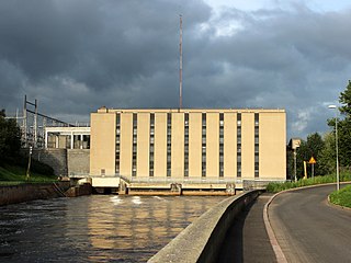
Merikoski Power Plant is a hydroelectric power station and a dam in the Koskikeskus district in Oulu, Finland. The plant is owned by the Oulun Energia municipal enterprise of the city of Oulu.
Vihreäsaari is an uninhabited island and a neighbourhood in the Tuira area in the city of Oulu, Finland. It is separated from the Hietasaari island by the Johteensalmi strait.

Qstock is an annual two-day rock festival held at the end of July in Oulu, Finland. The festival lineup includes some of the biggest names in both domestic and international music scene, regardless of the genre. The first Qstock festival was organised in 2003. The festival has quickly grown into the biggest summer event in northern Finland, with its 30,000 visitors. As of July 2022, Qstock has been sold out nine times in a row. The festival acts as sort of a successor of the former Kuusrock festival which was organised in Oulu from 1970s until early 1990s.

The Oulu Cemetery is a cemetery located in the Intiö district close to the city centre of Oulu, Finland.

Toppila is a district of Oulu, Finland. It is bounded by the Toppilansalmi strait in the south and west, railway in the east and the Taskila district in the north. The Möljä Bridge over the Toppilansalmi strait connects Toppila with the Toppilansaari district.

Karjasilta is a district in the Höyhtyä area in the city of Oulu, Finland. The district close to the city centre is bordered by the Raksila district to the north, Finnish national road 4 to the east, the Vanhatulli and Limingantulli districts to the west and the Nokela and Höyhtyä districts to the south.

Oulujoki is a former municipality of Finland. The municipality had a population of 5,230 (1963) and covered a land area of 606.1 square kilometres (234.0 sq mi). Its neighbouring municipalities were Kempele, Kiiminki, Muhos, Oulu, Tyrnävä, Utajärvi and Ylikiiminki. The municipality was named after the river Oulujoki.
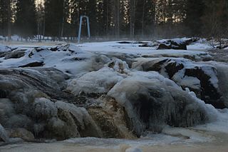
Koitelinkoski is an outdoor recreation area located along the Kiiminkijoki river in the Kiiminki district in Oulu, Finland. The area consists of small islands which divide the free-flowing river into smaller streams and rapids. The Koitelinkoski rapids stretch about three kilometers on the river. The rapids are one of the most impressive ones on the Kiiminkijoki river.
