
Oulu is a city and municipality of 208 939 inhabitants in the region of North Ostrobothnia, Finland. It is the most populous city in Northern Finland, and the fifth most populous in the country.
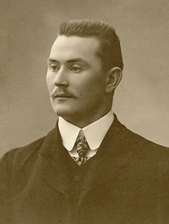
Yrjö Erik Mikael Saarela was a Finnish wrestler, who won an Olympic gold and a world championship.

The Rotuaari is a pedestrian zone in the Pokkinen district in Oulu, Finland. The area, together with the Oulu Market Square, is being managed by the city centre shopkeeper association Oulun Liikekeskus ry.

Oulu University Hospital is a university hospital in Oulu, Finland. It is the northernmost of the five university hospitals in Finland.

Pikisaari is a district of the city of Oulu, Finland. The district consists of Pikisaari and Korkeasaari islands connected due to the post-glacial rebound. Pikisaari is located near the city centre in the estuary of Oulujoki River in between market square and Hietasaari island.

Intiö is a district of the city centre area of Oulu, Finland. It is located on the southern bank of the Oulu River in between Myllytulli and Värttö districts.
Tietomaa is a science centre in Oulu, Finland. It is located in Myllytulli district near the city centre. It is the first science centre in Finland and it was opened to the public on 29 June 1988.

The Oulu Museum of Art (OMA) is an art museum in the Myllytulli neighbourhood in Oulu. It is located on the edge of the Hupisaaret Islands park.

Raksila is a District of the city centre area of Oulu, Finland. It is bounded by the Oulu railway station to the west, the Oulu Cemetery in the Intiö district to the north, the Finnish national road 4 to the east and the Finnish national road 22 to the south.

Toppilansaari is a neighbourhood in the Tuira area in the city of Oulu, Finland. It is located on the south side of the Toppilansalmi strait. Toppilansaari was separated from the Hietasaari district while it was rezoned to residential development in the early 2000s. The westernmost part of the neighbourhood was the location for the Finnish Housing Fair in 2005. The Möljä Bridge over the Toppilansalmi strait connects Toppilansaari with the Toppila neighbourhood. The bridge was completed in 2012.

Koskikeskus is a neighbourhood in the Tuira area in the city of Oulu, Finland. The neighbourhood is located in the estuary of the river Oulujoki. The Tuira Bridges in Koskikeskus connect the city centre and Tuira neighbourhoods. The first bridges through the delta were built in late 1860s.

Hietasaari is district in the Tuira area in the city of Oulu, Finland. The district consists of Mustasaari and Hietasaari islands, separated by the Mustasalmi strait, together with some smaller islands. Hietasaari is zoned as recreation area with only few people living in the district permanently.

Hollihaka is a district of the city centre area of Oulu, Finland. It is bounded by the estuary of the Oulujoki river to the west, the Vanhatulli district to the north, the Leveri district to the east and the Nuottasaari district to the south. Together with the two latter districts, Hollihaka forms a neighbourhood called Heinäpää.
Pokkinen is a district of the city centre area of Oulu, Finland. Together with districts of Vaara and Vanhatulli, Pokkinen forms the central business district of Oulu. It is bounded by the estuary of the Oulujoki river to the west, the Koskikeskus and Myllytulli districts to the north, the Vaara district to the east and the Vanhatulli district to the south.

Vanhatulli is a district of the city centre area of Oulu, Finland. Together with the districts of Pokkinen and Vaara, Vanhatulli forms the central business district of Oulu. It is bounded by the estuary of the Oulujoki river to the west, the Pokkinen and Vaara districts to the north, the Leveri and Hollihaka districts to the south and the railway to the east.
Vihreäsaari is an uninhabited island and a neighbourhood in the Tuira area in the city of Oulu, Finland. It is separated from the Hietasaari island by the Johteensalmi strait.
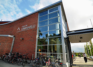
Oulu Swimming Pool is an indoor swimming pool in the Raksila neighbourhood in Oulu, Finland. It is the biggest of the three indoor swimming pools in Oulu and one of the biggest in Finland. The swimming pool designed by architect Risto Harju was completed in 1974.

Kiiminki is a district of Oulu, Finland. Together with Alakylä, Hannus and Huttukylä districts, it forms the Kiiminki area. The center of the district is located where the National road 20 crosses the Kiiminkijoki river. The district was established in 2013 when the Kiiminki municipality together with Haukipudas, Oulunsalo and Yli-Ii municipalities were merged with the city of Oulu.

Toppila is a district of Oulu, Finland. It is bounded by the Toppilansalmi strait in the south and west, railway in the east and the Taskila district in the north. The Möljä Bridge over the Toppilansalmi strait connects Toppila with the Toppilansaari district.

Nuottasaari is a district of Oulu, Finland. It is located south of the city centre of Oulu. Nuottasaari is bounded by the delta of the Oulujoki river in the Northwest, the Bothnian Bay and the Äimärautio district in the South and the Limingantulli, Leveri and Hollihaka districts in the East.
