
The Mid-Atlantic Ridge is a mid-ocean ridge located along the floor of the Atlantic Ocean, and part of the longest mountain range in the world. In the North Atlantic, the ridge separates the North American from the Eurasian plate and the African plate, north and south of the Azores triple junction. In the South Atlantic, it separates the African and South American plates. The ridge extends from a junction with the Gakkel Ridge northeast of Greenland southward to the Bouvet triple junction in the South Atlantic. Although the Mid-Atlantic Ridge is mostly an underwater feature, portions of it have enough elevation to extend above sea level, for example in Iceland. The ridge has an average spreading rate of about 2.5 centimetres (1 in) per year.
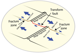
A fracture zone is a linear feature on the ocean floor—often hundreds, even thousands of kilometers long—resulting from the action of offset mid-ocean ridge axis segments. They are a consequence of plate tectonics. Lithospheric plates on either side of an active transform fault move in opposite directions; here, strike-slip activity occurs. Fracture zones extend past the transform faults, away from the ridge axis; are usually seismically inactive, although they can display evidence of transform fault activity, primarily in the different ages of the crust on opposite sides of the zone.
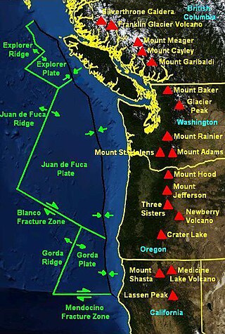
The Mendocino Fracture Zone is a fracture zone and transform boundary over 4000 km long, starting off the coast of Cape Mendocino in far northern California. It runs westward from a triple junction with the San Andreas Fault and the Cascadia subduction zone to the southern end of the Gorda Ridge. It continues on west of its junction with the Gorda Ridge, as an inactive remnant section which extends for several hundred miles.
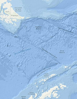
The Shackleton Fracture Zone (SFZ) is an undersea fracture zone, mid-oceanic ridge and fault located in the Drake Passage, at the separation between the Scotia plate from the Antarctic plate. It extends between 59° and 60°40' south latitude and between 56°30' and 61° west longitude and runs in a northwest to southeast direction from the South American continental shelf to the South Shetland Islands. Chile claims the area as part of its Outer Continental Shelf boundary.
Astrid Ridge is an undersea ridge on the continental margin of Dronning Maud Land, East Antarctica. It is present on the GEBCO 5th edition charts. The name was approved by the Advisory Committee for Undersea Features in June 1987.
Prospect Glacier is a glacier between Kinnear Mountains and Mayer Hills, flowing north into Forster Ice Piedmont on the west coast of Antarctic Peninsula. It was first roughly surveyed in 1936 by the British Graham Land Expedition (BGLE) under Rymill. In 1954 the United Kingdom Antarctic Place-Names Committee (UK-APC) gave the name Prospect Pass to a col between Eureka Glacier and the glacier here described. During resurvey of the area by the Falkland Islands Dependencies Survey (FIDS) in 1958, the col was found to be an indeterminate feature, while this glacier is well marked and requires a name.

The SV Mandalay is a three-masted schooner measuring 163.75 ft (49.91 m) pp, with a wrought iron hull. It was built as the private yacht Hussar (IV), and would later become the research vessel Vema, one of the world's most productive oceanographic research vessels. The ship currently sails as the cruising yacht Mandalay in the Caribbean.
The Antipodes fracture zone is an undersea fracture zone named in association with Antipodes Island. The name was proposed by Dr. Steven C. Cande of the Scripps Institution of Oceanography, and approved by the Advisory Committee on Undersea Features in September 1997.
Balleny Fracture Zone is a fracture zone in the Southern Ocean that extends south towards the Balleny Islands. The name was approved by the Advisory Committee for Undersea Features in December 1971.
Vinogradov Fracture Zone is an Antarctic undersea fracture zone named for Alexandr Vinogradov, a Russian scientist/geochemist and first Director of the Vernadsky Institute of Geochemistry (GEOKHI). The name was proposed by Dr. Galina Agapova of the Geological Institute of the Russian Academy of Sciences, and was approved in September 1997.
Pitman fracture zone is an undersea fracture zone named for Dr. Walter C. Pitman III, a geophysicist and pioneer in studies of continental drift and seafloor spreading. Name proposed by Drs. Cande, Haxby and Raymond, Lamont–Doherty Geological Observatory ; name approved 3/93.
Eadie Island is an island 2 km (1.2 mi) long which lies between Aspland Island and O'Brien Island, in the South Shetland Islands of Antarctica. A strong marine channel, named Tasman Rip, runs between Eadie Island and O'Brien Island.
The Emerald Fracture Zone is an undersea fracture zone running the distance from the southwest corner of the Campbell Plateau to the northern tip of Iselin Bank. The name was proposed by Dr. Steven C. Cande of the Scripps Institution of Oceanography for the vessel Emerald, which traversed this region in 1821, and was approved by the Advisory Committee for Undersea Features in June 1997. The Emerald Basin to its north west was named from the same source. Some have restricted the name to the southern east west orientated transform fault zone but the north south orientated faults that define the eastern boundary of the Emerald Basin are generally included in the literature.
Freeden Bank is a submarine bank named for Wilhelm von Freeden, the founder of the Norddeutsche Seewarte, the forerunner of the German Hydrographic Office. The name was proposed by Dr. Heinrich Hinze of the Alfred Wegener Institute for Polar and Marine Research, Bremerhaven, Germany, and was approved by the Advisory Committee for Undersea Features in June 1997.
The Heirtzler fracture zone is an undersea fracture zone located south of New Zealand, near Antarctica.
Helmert Bank is a submarine bank in the Weddell Sea named for the German geodesist Friedrich Robert Helmert. The name was proposed by Dr. Heinrich Hinze of the Alfred Wegener Institute for Polar and Marine Research, Bremerhaven, Germany, and was approved by the Advisory Committee for Undersea Features in June 1997.
The Hjort Fracture Zone is an undersea fracture zone in Antarctica. The name was approved by the Advisory Committee for Undersea Features in December 1971.
The Hero Fracture Zone is an undersea fracture zone in the Antarctic. Its name was approved by the Advisory Committee on Undersea Features in June 1987.

Hough Glacier is a glacier in central Doyran Heights in the Sentinel Range of Ellsworth Mountains, Antarctica, rising just south of Mount Tuck and flowing east-southeast for 10 nautical miles between Guerrero Glacier and Remington Glacier. It was first mapped by the United States Geological Survey from surveys and U.S. Navy air photos, 1957–59, and was named by the Advisory Committee on Antarctic Names for William S. Hough, who made ionosphere studies at South Pole Station in 1957.

Ampullinopsis is an extinct taxonomic genus of deep-water sea snails, marine gastropod molluscs in the clade Sorbeoconcha. These sea snails were epifaunal grazers. Sea snails of this genus lived from Paleocene epoch to Miocene epoch.