Kovachevo, Stara Zagora Province

Last updated

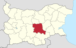
Coordinates: 42°14′N026°04′E / 42.233°N 26.067°E / 42.233; 26.067 Kovachevo (Bulgarian : Ковачево) is a village in southern Bulgaria, located in the municipality of Radnevo in the Stara Zagora Province. [1]

Geographic coordinate system Coordinate system

A geographic coordinate system is a coordinate system that enables every location on Earth to be specified by a set of numbers, letters or symbols. The coordinates are often chosen such that one of the numbers represents a vertical position and two or three of the numbers represent a horizontal position; alternatively, a geographic position may be expressed in a combined three-dimensional Cartesian vector. A common choice of coordinates is latitude, longitude and elevation. To specify a location on a plane requires a map projection.

Bulgarian language South Slavic language

Bulgarian, is an Indo-European language and a member of the Southern branch of the Slavic language family.

Radnevo Place in Stara Zagora, Bulgaria

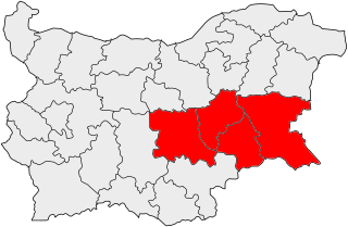
Radnevo is a town in southern Bulgaria, part of Stara Zagora Province, located in the eastern Upper Thracian Lowlands. It is the administrative centre of the homonymous Radnevo Municipality. As of December 2009, the town has a population of 13,384 inhabitants.

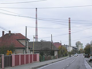
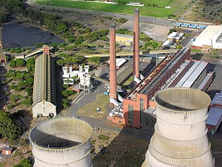
Kovachevo is the location of the Maritsa Iztok-2 power station. This power station was ranked as the industrial facility that is causing the highest damage costs to health and the environment in Bulgaria and the entire European Union. [2]

Maritsa Iztok Complex coal power plant

The Maritsa Iztok Complex is the largest energy complex in South Eastern Europe. It is located in Stara Zagora Province, south-central Bulgaria. It consists of three lignite-fired thermal power stations. The complex is located in a large lignite coal basin, which includes several mines, enrichment plants, a briquette plant and its own railway system. The development of the thermal power and mining complex at Maritsa Iztok began in 1952, but the lignite deposits used to be known well in the mid-19th century. The Maritsa Iztok mines and power plants are interdependent as the only market for coal is the power plants, while the power plants have no other supplier of coal but the mines.

Power station facility generating electric power

A power station, also referred to as a power plant or powerhouse and sometimes generating station or generating plant, is an industrial facility for the generation of electric power. Most power stations contain one or more generators, a rotating machine that converts mechanical power into electrical power. The relative motion between a magnetic field and a conductor creates an electrical current. The energy source harnessed to turn the generator varies widely. Most power stations in the world burn fossil fuels such as coal, oil, and natural gas to generate electricity. Others use nuclear power, but there is an increasing use of cleaner renewable sources such as solar, wind, wave and hydroelectric.

Health, as defined by the World Health Organization (WHO), is "a state of complete physical, mental and social well-being and not merely the absence of disease or infirmity." This definition has been subject to controversy, as it may have limited value for implementation. Health may be defined as the ability to adapt and manage physical, mental and social challenges throughout life.

Related Research Articles

Stara Zagora Province Province in Bulgaria

Stara Zagora, formerly known as the Stara Zagora okrug, is a province of south-central Bulgaria. It is named after its administrative and industrial centre—the city of Stara Zagora—the sixth-biggest town in the country. The province embraces a territory of 5,151.1 km² that is divided into 11 municipalities with a total population, as of December 2009, of 350,925 inhabitants.

Stara Zagora Place in Bulgaria

Stara Zagora is the sixth-largest city in Bulgaria, and the administrative capital of the homonymous Stara Zagora Province.

Sredna Gora mountain range

Sredna Gora is a mountain range in central Bulgaria, situated south of and parallel to the Balkan mountain range and extending from the Iskar River to the west and the elbow of Tundzha north of Yambol to the east. Sredna Gora is 285 km long, reaching 50 km at its greatest width. Its highest peak is Golyam Bogdan at 1,604 m (5,262 ft).

Northern Thrace northern part of the historical region of Thrace in southeastern Europe

Northern Thrace or North Thrace constitutes the northern and the largest part of the historical region of Thrace. Bulgarian Thrace is located in Southern Bulgaria and refers to the whole territory south of the Balkan Mountains and east of the Mesta River; to the Greek and Turkish borders in the south and to the Black Sea in the east. It encompasses Sredna Gora, the Upper Thracian Plain and 90% of the Rhodopes. The climate differs from continental to transitional continental and mountainous. The highest temperature recorded in Bulgaria occurred here: it was 45.2 °C at Sadovo in 1916. The important rivers of the region are the Maritsa and its tributaries. Important cities include Plovdiv, Burgas, Stara Zagora, Sliven, Haskovo, Yambol, Pazardzhik, Asenovgrad, Kardzhali, Dimitrovgrad, Kazanlak and Smolyan. Northern Thrace has an area of 42,073 km².

The Stara Zagora Transmitter was a high power mediumwave broadcasting station near Stara Zagora in Bulgaria.

Bulgarian National Radio radio station

Bulgarian National Radio is Bulgaria's national radio broadcasting organization. It operates two national and seven regional channels, as well as an international service – Radio Bulgaria – which broadcasts in 11 languages.

Upper Thracian Plain

The Upper Thracian Plain constitutes the northern part of the historical region of Thrace. It is located in southern Bulgaria, between the Sredna Gora mountains to the north and west; the Rhodopes, Sakar and Strandzha to the south; and the Black Sea to the east. A fertile agricultural region, the Upper Thracian Plain proper has an area of 16,032 square kilometres (6,190 sq mi) and an average elevation of 168 metres (551 ft). The plain is part of Northern Thrace. The climate is transitional continental. The highest temperature recorded in Bulgaria occurred here: it was 45.2 °C (113.4 °F) at Sadovo in 1916. The precipitation is 550 millimetres (22 in) a year. Important rivers are the Maritsa and its tributaries, the Tundzha, the Stryama, the Topolnitsa, and the Vacha. Important cities include Plovdiv, Burgas, Stara Zagora, Pazardzhik, Asenovgrad, Haskovo, Yambol and Sliven.

Nováky Power Plant coal power plant

The lignite fired Nováky Power Plant is located in Zemianske Kostoľany near the Novácke uhoľné bane coal mines in the District of Prievidza, Slovakia. In addition to electricity generation and supply, Nováky Power Plant provides for hot water supplies for heating of the towns of Prievidza, Nováky, Zemianske Kostoľany as well as for industrial and other organisations and steam for heat supplies to surrounding industrial enterprises. It has a 150m tall chimney, built in 1963 and a 300-metre tall chimney, built in 1976. Nováky Power plant is pixeled on Google Maps.

Energy in Bulgaria

Energy in Bulgaria describes energy and electricity production, consumption and trade in Bulgaria.

Zemianske Kostoľany Village in Slovakia

Zemianske Kostoľany is a village and municipality in Prievidza District in the Trenčín Region of western Slovakia.

Gurkovo Town in Stara Zagora, Bulgaria

Gurkovo is a small town in the Stara Zagora Province, South-central Bulgaria. It is the administrative centre of the homonymous Gurkovo Municipality. As of December 2009, the town has a population of 2,917 inhabitants.

Nikolaevo is a small town in Stara Zagora Province, South-central Bulgaria. It is the administrative centre of the homonymous Nikolaevo Municipality. As of December 2009, the town has a population of 2,872 inhabitants.

Yugoiztochen Planning Region planning region in Bulgaria

Yugoiztochen Planning Region is one of Bulgaria's planning regions. The capital is Burgas. It includes Burgas Province, Sliven Province, Yambol Province and Stara Zagora Province.

Opan Place in Stara Zagora, Bulgaria

Opan is a village in southern Bulgaria, part of Stara Zagora Province. It is the administrative centre of Opan Municipality, which lies in the southern part of Stara Zagora Province. The village is located south of the provincial capital of Stara Zagora, in the Upper Thracian Plain, the historical region of Thrace. The village was first mentioned in an Ottoman tax register of 1655.

Bulgarian Energy Holding EAD is a state owned energy holding company in Bulgaria. It was incorporated on 18 September 2008 after renaming Bulgargaz Holding EAD. In November 2009, the Bulgarian Government decided to list the company at the Bulgarian Stock Exchange – Sofia.

27th MMC – Stara Zagora

The 27th Multi-member Constituency – Stara Zagora is a constituency whose borders are the same as Stara Zagora Province in Bulgaria.

Neolithic Dwellings Museum museum in Stara Zagora, Bulgaria

Neolithic Dwellings Museum in Stara Zagora, Bulgaria is a museum in Stara Zagora, Bulgaria, which contains ruins of two of the oldest surviving buildings in the world.

European route E773 road in Europe

European route E 773 is a European B class road in Bulgaria, connecting the village of Popovica and the cities of Stara Zagora and Burgas.

References

  1. Kovachevo, Stara Zagora, Bulgaria at GEOnet Names Server
  2. "Industrial facilities causing the highest damage costs to health and the environment". European Environment Agency. Retrieved 25 November 2014.