Koya Chiefdom | |
|---|---|
| Country | |
| Province | North West Province |
| District | Port Loko District |
| Capital | Songo |
| Time zone | UTC+0 (GMT) |
Koya Chiefdom also known as Western Koya is a chiefdom in Port Loko District of Sierra Leone. [1] [2] Its capital is Songo.
Koya Chiefdom | |
|---|---|
| Country | |
| Province | North West Province |
| District | Port Loko District |
| Capital | Songo |
| Time zone | UTC+0 (GMT) |
Koya Chiefdom also known as Western Koya is a chiefdom in Port Loko District of Sierra Leone. [1] [2] Its capital is Songo.
Recently, Koya Chiefdom will be have industrial district named Sierra Leone Industrial Zone-Koya (SIZ-Koya) and built by the ARISE Integrated Industrial Platforms (ARISE IIP) with funding from Indian and South Korean investors. It is 15 km2 (1,500 ha; 3,700 acres) wide and powered by 100 MW (134,100 hp) solar power system. [3]
| District capital | 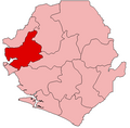 | |
|---|---|---|
| Chiefdoms | ||
| Towns | ||
| International | |
|---|---|
| National | |
| | This Sierra Leone location article is a stub. You can help Wikipedia by expanding it. |