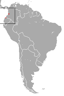
The Ecuadorian sac-winged bat is a species of sac-winged bat in the family Emballonuridae. It is found in Colombia and Ecuador. According to the IUCN Red List of Threatened Species, the population trend is decreasing for this species, due to habitat destruction through deforestation. In 2013, Bat Conservation International listed this species as one of the 35 species of its worldwide priority list of conservation.
Słupia Valley Landscape Park is a protected area in northern Poland.

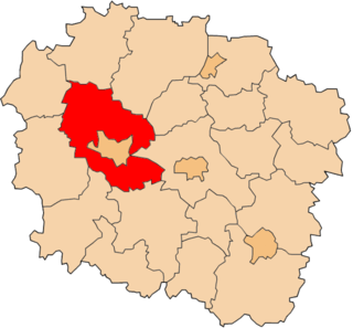
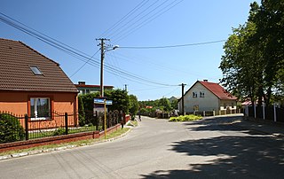
Brąchnówko is a village in the administrative district of Gmina Chełmża, within Toruń County, Kuyavian-Pomeranian Voivodeship, in north-central Poland. It lies approximately 7 kilometres (4 mi) south of Chełmża and 14 km (9 mi) north of Toruń.
Koziki-Jałbrzyków Stok is a village in the administrative district of Gmina Zambrów, within Zambrów County, Podlaskie Voivodeship, in north-eastern Poland.

Balekundri (K.H.) is a village in the southern state of Karnataka, India. It is located in the Belgaum taluk of Belgaum district in Karnataka.
Odry is a village in the administrative district of Gmina Czersk, within Chojnice County, Pomeranian Voivodeship, in northern Poland. It lies approximately 12 kilometres (7 mi) north of Czersk, 38 km (24 mi) north-east of Chojnice, and 67 km (42 mi) south-west of the regional capital Gdańsk.
Waśniewo-Gwoździe is a village in the administrative district of Gmina Janowiec Kościelny, within Nidzica County, Warmian-Masurian Voivodeship, in northern Poland.
Shamsabad is a village in Mehmandust Rural District, Kuraim District, Nir County, Ardabil Province, Iran. At the 2006 census, its population was 35, in 10 families.

Tři Dvory is a village and municipality in Kolín District in the Central Bohemian Region of the Czech Republic.
Zinacatepec (municipality) is a town and municipality in Puebla in south-eastern Mexico.
Ahl El Ksar is a town and commune in Bouïra Province, Algeria. According to the 1998 census it has a population of 12,315.
Hirschberg is a mountain of Hesse, Germany.

Christ the King Church is a Roman Catholic church in Trumbull, Connecticut, part of the Diocese of Bridgeport.

Zmievskaya Balka, Zmiyovskaya Balka is a site in Rostov-on-Don, Russia at which 27,000 Jews and Soviet civilians were massacred in 1942 to 1943 by the SS Einsatzgruppe D during the Holocaust in Russia. It is considered to be the largest single mass murder site of Jews on Russian territory during the Second World War. The name means "the ravine of the snakes".
Kosmos 2456 is one of a set of three Russian military satellites launched in 2009 as part of the GLONASS satellite navigation system. It was launched with Kosmos 2457 and Kosmos 2458.

The Dömitz Railway Bridge is a partially complete railway bridge over the Elbe River near the town of Dömitz, Germany. As constructed, it had a length of 1,000 metres and was the longest railway bridge in Germany at that time. It was part of the Wittenberge–Buchholz railway.
Sauter Township is a township in Walsh County, North Dakota.
German submarine U-2531 was a Type XXI U-boat of Nazi Germany's Kriegsmarine, built for service in World War II. She was ordered on 6 November 1943, and was laid down on 3 October 1944 at the Blohm & Voss yard at Hamburg, as yard number 2531. She was launched on 5 December 1944, and commissioned under the command of Oberleutnant zur See Helmut Niss, on 10 January 1945.
Veni Shankar Jha was an Indian educationist. He served as the director of public instruction of the Central Provinces and Berar and was the vice chancellor of Banaras Hindu University from 3 July 1956 to 6 April 1960. The Government of India awarded him Padma Bhushan, the third highest Indian civilian award, in 1971.