Magdalenka, Kuyavian-Pomeranian Voivodeship

Last updated
Magdalenka
Village
Country Flag of Poland.svg  Poland
Voivodeship Kuyavian-Pomeranian
County Bydgoszcz County
Gmina Dobrcz

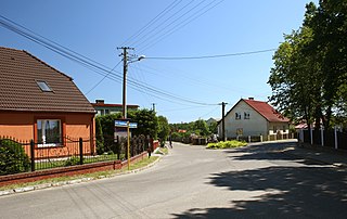
Magdalenka [maɡdaˈlɛŋka] (German : Magdalenowo, 1939-45: Magdalenenhof) [1] is a village in the administrative district of Gmina Dobrcz, within Bydgoszcz County, Kuyavian-Pomeranian Voivodeship, in north-central Poland. [2]

German language West Germanic language

German is a West Germanic language that is mainly spoken in Central Europe. It is the most widely spoken and official or co-official language in Germany, Austria, Switzerland, South Tyrol (Italy), the German-speaking Community of Belgium, and Liechtenstein. It is also one of the three official languages of Luxembourg and a co-official language in the Opole Voivodeship in Poland. The languages which are most similar to German are the other members of the West Germanic language branch: Afrikaans, Dutch, English, the Frisian languages, Low German/Low Saxon, Luxembourgish, and Yiddish. There are also strong similarities in vocabulary with Danish, Norwegian and Swedish, although those belong to the North Germanic group. German is the second most widely spoken Germanic language, after English.

Gmina Dobrcz Gmina in Kuyavian-Pomeranian, Poland

Gmina Dobrcz is a rural gmina in Bydgoszcz County, Kuyavian-Pomeranian Voivodeship, in north-central Poland. Its seat is the village of Dobrcz, which lies approximately 20 kilometres (12 mi) north-east of Bydgoszcz.
Bydgoszcz County County in Kuyavian-Pomeranian, Poland

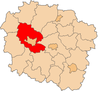
Bydgoszcz County is a unit of territorial administration and local government (powiat) in Kuyavian-Pomeranian Voivodeship, north-central Poland. It was created on 1 January 1999 as a result of the Polish local government reforms passed in 1998. Its administrative seat is the city of Bydgoszcz, although the city is not part of the county. The only towns in Bydgoszcz County are Solec Kujawski, which lies 17 km (11 mi) east of Bydgoszcz, and Koronowo, 23 km (14 mi) north of Bydgoszcz.

Related Research Articles

Porcsalma Place in Szabolcs-Szatmár-Bereg, Hungary

Porcsalma is a village in Szabolcs-Szatmár-Bereg county, in the Northern Great Plain region of eastern Hungary.

Trzebień is a village in the administrative district of Gmina Dobrcz, within Bydgoszcz County, Kuyavian-Pomeranian Voivodeship, in north-central Poland.

Brąchnówko Village in Kuyavian-Pomeranian, Poland

Brąchnówko is a village in the administrative district of Gmina Chełmża, within Toruń County, Kuyavian-Pomeranian Voivodeship, in north-central Poland. It lies approximately 7 kilometres (4 mi) south of Chełmża and 14 km (9 mi) north of Toruń.

Jeziorek is a village in the administrative district of Gmina Szudziałowo, within Sokółka County, Podlaskie Voivodeship, in north-eastern Poland, close to the border with Belarus.

Magdalenka is a village in the administrative district of Gmina Rozprza, within Piotrków County, Łódź Voivodeship, in central Poland.

Magdalenka, Gmina Będków Village in Łódź, Poland

Magdalenka is a village in the administrative district of Gmina Będków, within Tomaszów Mazowiecki County, Łódź Voivodeship, in central Poland. It lies approximately 4 kilometres (2 mi) south-east of Będków, 17 km (11 mi) west of Tomaszów Mazowiecki, and 33 km (21 mi) south-east of the regional capital Łódź.

Magdalenka, Lublin Voivodeship Village in Lublin, Poland

Magdalenka is a village in the administrative district of Gmina Ulhówek, within Tomaszów Lubelski County, Lublin Voivodeship, in eastern Poland, close to the border with Ukraine. It lies approximately 4 kilometres (2 mi) south-west of Ulhówek, 25 km (16 mi) east of Tomaszów Lubelski, and 125 km (78 mi) south-east of the regional capital Lublin.

Magdalenka, Masovian Voivodeship Village in Masovian, Poland

Magdalenka is a village in the administrative district of Gmina Lesznowola, within Piaseczno County, Masovian Voivodeship, in east-central Poland. It lies approximately 3 kilometres (2 mi) north-west of Lesznowola, 9 km (6 mi) north-west of Piaseczno, and 15 km (9 mi) south-west of Warsaw.

Chmielewo is a village in the administrative district of Gmina Pułtusk, within Pułtusk County, Masovian Voivodeship, in east-central Poland.

Bagna is a settlement in the administrative district of Gmina Czersk, within Chojnice County, Pomeranian Voivodeship, in northern Poland.

Bukowa Góra is a settlement in the administrative district of Gmina Czersk, within Chojnice County, Pomeranian Voivodeship, in northern Poland.

Łąg-Kolonia is a village in the administrative district of Gmina Czersk, within Chojnice County, Pomeranian Voivodeship, in northern Poland.

Ustronie is a settlement in the administrative district of Gmina Czersk, within Chojnice County, Pomeranian Voivodeship, in northern Poland.

Zawada is a village in the administrative district of Gmina Czersk, within Chojnice County, Pomeranian Voivodeship, in northern Poland.

Odry, Poland Village in Pomeranian, Poland

Odry is a village in the administrative district of Gmina Czersk, within Chojnice County, Pomeranian Voivodeship, in northern Poland. It lies approximately 12 kilometres (7 mi) north of Czersk, 38 km (24 mi) north-east of Chojnice, and 67 km (42 mi) south-west of the regional capital Gdańsk.

Siejba is a settlement in the administrative district of Gmina Wydminy, within Giżycko County, Warmian-Masurian Voivodeship, in northern Poland.

Mały Bór is a settlement in the administrative district of Gmina Iława, within Iława County, Warmian-Masurian Voivodeship, in northern Poland.

Zawady Małe is a settlement in the administrative district of Gmina Ostróda, within Ostróda County, Warmian-Masurian Voivodeship, in northern Poland.

Liên Sơn is a commune () and village in Tân Yên District, Bắc Giang Province, in northeastern Vietnam.

Palais Quartier building complex in Frankfurt

The Palais Quartier, formerly known as FrankfurtHochVier, is a building complex in the Innenstadt district of Frankfurt, Germany. It was built from 2004 to 2011.

References


Coordinates: 53°16′37″N18°06′53″E / 53.2769°N 18.1147°E / 53.2769; 18.1147

Geographic coordinate system Coordinate system

A geographic coordinate system is a coordinate system that enables every location on Earth to be specified by a set of numbers, letters or symbols. The coordinates are often chosen such that one of the numbers represents a vertical position and two or three of the numbers represent a horizontal position; alternatively, a geographic position may be expressed in a combined three-dimensional Cartesian vector. A common choice of coordinates is latitude, longitude and elevation. To specify a location on a plane requires a map projection.