Koleśniki is a village in the administrative district of Gmina Mońki, within Mońki County, Podlaskie Voivodeship, in north-eastern Poland. It lies approximately 5 kilometres (3 mi) north-east of Mońki and 41 km (25 mi) north-west of the regional capital Białystok.
Krzeczkowo is a village in the administrative district of Gmina Mońki, within Mońki County, Podlaskie Voivodeship, in north-eastern Poland. It lies approximately 7 kilometres (4 mi) north-east of Mońki and 40 km (25 mi) north-west of the regional capital Białystok.
Ołdaki is a village in the administrative district of Gmina Mońki, within Mońki County, Podlaskie Voivodeship, in north-eastern Poland. It lies approximately 8 kilometres (5 mi) north of Mońki and 47 km (29 mi) north-west of the regional capital Białystok.
Brzozówka Folwarczna is a village in the administrative district of Gmina Jasionówka, within Mońki County, Podlaskie Voivodeship, in north-eastern Poland. It lies approximately 20 kilometres (12 mi) east of Mońki and 27 km (17 mi) north of the regional capital Białystok.
Czarnystok is a village in the administrative district of Gmina Jasionówka, within Mońki County, Podlaskie Voivodeship, in north-eastern Poland. It lies approximately 4 kilometres (2 mi) south-east of Jasionówka, 19 km (12 mi) east of Mońki, and 31 km (19 mi) north of the regional capital Białystok.
Dobrzyniówka is a village in the administrative district of Gmina Jasionówka, within Mońki County, Podlaskie Voivodeship, in north-eastern Poland. It lies approximately 19 kilometres (12 mi) east of Mońki and 28 km (17 mi) north of the regional capital Białystok.
Jasionóweczka is a village in the administrative district of Gmina Jasionówka, within Mońki County, Podlaskie Voivodeship, in north-eastern Poland. It lies approximately 2 kilometres (1 mi) west of Jasionówka, 15 km (9 mi) east of Mońki, and 33 km (21 mi) north of the regional capital Białystok.
Kalinówka Królewska is a village in the administrative district of Gmina Jasionówka, within Mońki County, Podlaskie Voivodeship, in north-eastern Poland. It lies approximately 5 kilometres (3 mi) north-west of Jasionówka, 12 km (7 mi) east of Mońki, and 36 km (22 mi) north of the regional capital Białystok.
Krasne Folwarczne is a village in the administrative district of Gmina Jasionówka, within Mońki County, Podlaskie Voivodeship, in north-eastern Poland. It lies approximately 9 kilometres (6 mi) south-east of Jasionówka, 21 km (13 mi) east of Mońki, and 25 km (16 mi) north of the regional capital Białystok.
Krasne Małe is a village in the administrative district of Gmina Jasionówka, within Mońki County, Podlaskie Voivodeship, in north-eastern Poland. It lies approximately 10 kilometres (6 mi) south of Jasionówka, 21 km (13 mi) south-east of Mońki, and 23 km (14 mi) north of the regional capital Białystok.
Kujbiedy is a village in the administrative district of Gmina Jasionówka, within Mońki County, Podlaskie Voivodeship, in north-eastern Poland. It lies approximately 3 kilometres (2 mi) south-east of Jasionówka, 17 km (11 mi) east of Mońki, and 31 km (19 mi) north of the regional capital Białystok.
Łękobudy is a village in the administrative district of Gmina Jasionówka, within Mońki County, Podlaskie Voivodeship, in north-eastern Poland. It lies approximately 18 kilometres (11 mi) east of Mońki and 28 km (17 mi) north of the regional capital Białystok.
Milewskie is a village in the administrative district of Gmina Jasionówka, within Mońki County, Podlaskie Voivodeship, in north-eastern Poland. It lies approximately 4 kilometres (2 mi) south of Jasionówka, 15 km (9 mi) east of Mońki, and 30 km (19 mi) north of the regional capital Białystok.
Zofiówka is a village in the administrative district of Gmina Knyszyn, within Mońki County, Podlaskie Voivodeship, in north-eastern Poland. It lies approximately 6 kilometres (4 mi) north-east of Knyszyn, 14 km (9 mi) south-east of Mońki, and 29 km (18 mi) north-west of the regional capital Białystok.
Golędzin is a village in the administrative district of Gmina Zakrzew, within Random County, Masovian Voivodeship, in east-central Poland. It lies approximately 3 kilometres (2 mi) south-west of Zakrzew, 14 km (9 mi) west of Radom, and 87 km (54 mi) south of Warsaw.
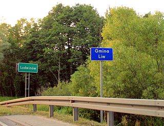
Ludwinów is a village in the administrative district of Gmina Liw, within Węgrów County, Masovian Voivodeship, in east-central Poland. It lies approximately 5 kilometres (3 mi) north-west of Węgrów and 72 km (45 mi) east of Warsaw.
Górki is a village in the administrative district of Gmina Puszcza Mariańska, within Żyrardów County, Masovian Voivodeship, in east-central Poland. It lies approximately 6 kilometres (4 mi) east of Puszcza Mariańska, 8 km (5 mi) south of Żyrardów, and 47 km (29 mi) south-west of Warsaw.
Okrągłe is a village in the administrative district of Gmina Dąbrówno, within Ostróda County, Warmian-Masurian Voivodeship, in northern Poland. It lies approximately 4 kilometres (2 mi) west of Dąbrówno, 30 km (19 mi) south of Ostróda, and 52 km (32 mi) south-west of the regional capital Olsztyn.
Warchlinko is a village in the administrative district of Gmina Stargard, within Stargard County, West Pomeranian Voivodeship, in north-western Poland. It lies approximately 12 kilometres (7 mi) north of Stargard and 27 km (17 mi) east of the regional capital Szczecin.