Słupowiec is a village in the administrative district of Gmina Kcynia, within Nakło County, Kuyavian-Pomeranian Voivodeship, in north-central Poland. It lies approximately 9 kilometres (6 mi) west of Kcynia, 21 km (13 mi) south-west of Nakło nad Notecią, and 44 km (27 mi) west of Bydgoszcz.
Kołodzież is a village in the administrative district of Gmina Mońki, within Mońki County, Podlaskie Voivodeship, in north-eastern Poland. It lies approximately 5 kilometres (3 mi) south-west of Mońki and 39 km (24 mi) north-west of the regional capital Białystok.
Kuczyn is a village in the administrative district of Gmina Mońki, within Mońki County, Podlaskie Voivodeship, in north-eastern Poland. It lies approximately 2 kilometres (1 mi) south of Mońki and 39 km (24 mi) north-west of the regional capital Białystok.
Magnusze is a village in the administrative district of Gmina Mońki, within Mońki County, Podlaskie Voivodeship, in north-eastern Poland.
Brzozówka Folwarczna is a village in the administrative district of Gmina Jasionówka, within Mońki County, Podlaskie Voivodeship, in north-eastern Poland. It lies approximately 20 kilometres (12 mi) east of Mońki and 27 km (17 mi) north of the regional capital Białystok.
Czarnystok is a village in the administrative district of Gmina Jasionówka, within Mońki County, Podlaskie Voivodeship, in north-eastern Poland. It lies approximately 4 kilometres (2 mi) south-east of Jasionówka, 19 km (12 mi) east of Mońki, and 31 km (19 mi) north of the regional capital Białystok.
Dobrzyniówka is a village in the administrative district of Gmina Jasionówka, within Mońki County, Podlaskie Voivodeship, in north-eastern Poland. It lies approximately 19 kilometres (12 mi) east of Mońki and 28 km (17 mi) north of the regional capital Białystok.
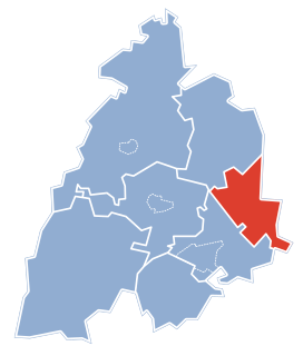
Jasionóweczka is a village in the administrative district of Gmina Jasionówka, within Mońki County, Podlaskie Voivodeship, in north-eastern Poland. It lies approximately 2 kilometres (1 mi) west of Jasionówka, 15 km (9 mi) east of Mońki, and 33 km (21 mi) north of the regional capital Białystok.
Kalinówka Królewska is a village in the administrative district of Gmina Jasionówka, within Mońki County, Podlaskie Voivodeship, in north-eastern Poland. It lies approximately 5 kilometres (3 mi) north-west of Jasionówka, 12 km (7 mi) east of Mońki, and 36 km (22 mi) north of the regional capital Białystok.
Koziniec is a village in the administrative district of Gmina Jasionówka, within Mońki County, Podlaskie Voivodeship, in north-eastern Poland. It lies approximately 5 kilometres (3 mi) north-west of Jasionówka, 13 km (8 mi) east of Mońki, and 38 km (24 mi) north of the regional capital Białystok.
Krasne Folwarczne is a village in the administrative district of Gmina Jasionówka, within Mońki County, Podlaskie Voivodeship, in north-eastern Poland. It lies approximately 9 kilometres (6 mi) south-east of Jasionówka, 21 km (13 mi) east of Mońki, and 25 km (16 mi) north of the regional capital Białystok.
Krasne Małe is a village in the administrative district of Gmina Jasionówka, within Mońki County, Podlaskie Voivodeship, in north-eastern Poland. It lies approximately 10 kilometres (6 mi) south of Jasionówka, 21 km (13 mi) south-east of Mońki, and 23 km (14 mi) north of the regional capital Białystok.
Kujbiedy is a village in the administrative district of Gmina Jasionówka, within Mońki County, Podlaskie Voivodeship, in north-eastern Poland. It lies approximately 3 kilometres (2 mi) south-east of Jasionówka, 17 km (11 mi) east of Mońki, and 31 km (19 mi) north of the regional capital Białystok.
Łękobudy is a village in the administrative district of Gmina Jasionówka, within Mońki County, Podlaskie Voivodeship, in north-eastern Poland. It lies approximately 18 kilometres (11 mi) east of Mońki and 28 km (17 mi) north of the regional capital Białystok.
Dzięciołowo is a village in the administrative district of Gmina Jaświły, within Mońki County, Podlaskie Voivodeship, in north-eastern Poland. It lies approximately 11 kilometres (7 mi) north-east of Jaświły, 22 km (14 mi) north-east of Mońki, and 50 km (31 mi) north of the regional capital Białystok.
Chojnowo is a village in the administrative district of Gmina Trzcianne, within Mońki County, Podlaskie Voivodeship, in north-eastern Poland. It lies approximately 5 kilometres (3 mi) north-west of Trzcianne, 11 km (7 mi) west of Mońki, and 45 km (28 mi) north-west of the regional capital Białystok.
Grabowo is a village in the administrative district of Gmina Dąbrowa Białostocka, within Sokółka County, Podlaskie Voivodeship, in north-eastern Poland. It lies approximately 4 kilometres (2 mi) north of Dąbrowa Białostocka, 33 km (21 mi) north of Sokółka, and 65 km (40 mi) north of the regional capital Białystok.
Gilówka Dolna is a village in the administrative district of Gmina Iłów, within Sochaczew County, Masovian Voivodeship, in east-central Poland. It lies approximately 3 kilometres (2 mi) north of Iłów, 22 km (14 mi) north-west of Sochaczew, and 69 km (43 mi) west of Warsaw.
Mrozy is a village in the administrative district of Gmina Puszcza Mariańska, within Żyrardów County, Masovian Voivodeship, in east-central Poland. It lies approximately 4 kilometres (2 mi) north of Puszcza Mariańska, 6 km (4 mi) south-west of Żyrardów, and 49 km (30 mi) south-west of Warsaw.
Krępa is a village in the administrative district of Gmina Bobolice, within Koszalin County, West Pomeranian Voivodeship, in north-western Poland. It lies approximately 16 kilometres (10 mi) north-west of Bobolice, 23 km (14 mi) south-east of Koszalin, and 136 km (85 mi) north-east of the regional capital Szczecin.