
North Bloomfield is an unincorporated community in central Bloomfield Township, Trumbull County, Ohio, United States. Although it is unincorporated, it has a post office, with the ZIP code of 44450. It lies at the intersection of State Routes 45 and 87.

Chwalibożyce is a village in the administrative district of Gmina Oława, within Oława County, Lower Silesian Voivodeship, in south-western Poland. Prior to 1945 it was in Germany.
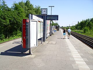
Krupunder station is on the Hamburg-Altona–Kiel line and is a railway station served by the city trains of the Hamburg S-Bahn. The railway station is located in the municipality Halstenbek in the district of Pinneberg, in Schleswig-Holstein, Germany, directly at the border to Hamburg.
Wiśniówka is a village in the administrative district of Gmina Tuchola, within Tuchola County, Kuyavian-Pomeranian Voivodeship, in north-central Poland. It lies approximately 3 kilometres (2 mi) north-east of Tuchola and 57 km (35 mi) north of Bydgoszcz.
Suszczy Borek is a village in the administrative district of Gmina Narewka, within Hajnówka County, Podlaskie Voivodeship, in north-eastern Poland, close to the border with Belarus.
Hucisko is a village in the administrative district of Gmina Drużbice, within Bełchatów County, Łódź Voivodeship, in central Poland. It lies approximately 6 kilometres (4 mi) south-east of Drużbice, 11 km (7 mi) north-east of Bełchatów, and 39 km (24 mi) south of the regional capital Łódź.
Młogoszyn is a village in the administrative district of Gmina Krzyżanów, within Kutno County, Łódź Voivodeship, in central Poland. It lies approximately 6 kilometres (4 mi) south of Krzyżanów, 13 km (8 mi) south-east of Kutno, and 40 km (25 mi) north of the regional capital Łódź.
Gnieździska is a village in the administrative district of Gmina Łopuszno, within Kielce County, Świętokrzyskie Voivodeship, in south-central Poland. It lies approximately 10 kilometres (6 mi) south of Łopuszno and 24 km (15 mi) west of the regional capital Kielce.
Stryczowice is a village in the administrative district of Gmina Waśniów, within Ostrowiec County, Świętokrzyskie Voivodeship, in south-central Poland. It lies approximately 6 kilometres (4 mi) south-east of Waśniów, 11 km (7 mi) south-west of Ostrowiec Świętokrzyski, and 48 km (30 mi) east of the regional capital Kielce.
Chęciny is a village in the administrative district of Gmina Górzno, within Garwolin County, Masovian Voivodeship, in east-central Poland. It lies approximately 4 kilometres (2 mi) north-east of Górzno, 9 km (6 mi) south-east of Garwolin, and 65 km (40 mi) south-east of Warsaw.
Pomiechowo is a village in the administrative district of Gmina Pomiechówek, within Nowy Dwór Mazowiecki County, Masovian Voivodeship, in east-central Poland. It lies approximately 2 kilometres (1 mi) south-west of Brody-Parcele, 6 km (4 mi) north-east of Nowy Dwór Mazowiecki, and 34 km (21 mi) north-west of Warsaw.
Bugaj is a village in the administrative district of Gmina Pobiedziska, within Poznań County, Greater Poland Voivodeship, in west-central Poland.
Rzymsko BG is a village in the administrative district of Gmina Dobra, within Turek County, Greater Poland Voivodeship, in west-central Poland.
Lipienica is a village in the administrative district of Gmina Ośno Lubuskie, within Słubice County, Lubusz Voivodeship, in western Poland. It lies approximately 5 kilometres (3 mi) north of Ośno Lubuskie, 27 km (17 mi) north-east of Słubice, and 37 km (23 mi) south-west of Gorzów Wielkopolski.
Bliżewo is a settlement in the administrative district of Gmina Płoskinia, within Braniewo County, Warmian-Masurian Voivodeship, in northern Poland. It lies approximately 6 kilometres (4 mi) north-west of Płoskinia, 11 km (7 mi) south of Braniewo, and 70 km (43 mi) north-west of the regional capital Olsztyn.
Cibórz is a village in the administrative district of Gmina Lidzbark, within Działdowo County, Warmian-Masurian Voivodeship, in northern Poland.

Łapka is a village in the administrative district of Gmina Barczewo, within Olsztyn County, Warmian-Masurian Voivodeship, in northern Poland.
Pomorce is a village in the administrative district of Gmina Sławoborze, within Świdwin County, West Pomeranian Voivodeship, in north-western Poland.

Parževići is a village in the municipality of Sokolac, Bosnia and Herzegovina.
Zuideramstel was from 1998 to 2010 a borough (stadsdeel) of Amsterdam, Netherlands. On 1 May 2010 it became part of the new Amsterdam Zuid borough.


