Related Research Articles

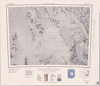
The Prince Charles Mountains are a major group of mountains in Mac. Robertson Land in Antarctica, including the Athos Range, the Porthos Range, and the Aramis Range. The highest peak is Mount Menzies, with a height of 3,228 m (10,591 ft). Other prominent peaks are Mount Izabelle and Mount Stinear. These mountains, together with other scattered peaks, form an arc about 420 km (260 mi) long, extending from the vicinity of Mount Starlight in the north to Goodspeed Nunataks in the south.
Athos Range is the northernmost range in the Prince Charles Mountains of Mac. Robertson Land, Antarctica. The range consists of many individual mountains and nunataks that trend east–west for 40 miles (64 km) along the north side of Scylla Glacier.
Zaneveld Glacier is a broad tributary glacier, flowing from the polar plateau northwest between Roberts Massif and Cumulus Hills to enter the upper part of Shackleton Glacier. Named by Advisory Committee on Antarctic Names (US-ACAN) for Jacques S. Zaneveld, United States Antarctic Research Program (USARP) biologist at McMurdo Station, 1963–64 and 1964–65, who participated in the cruise of the USS Glacier, January–March 1965.
Index Peak is a peak over 1,220 metres (4,000 ft) high, standing 7.5 miles (12 km) southeast of Cape Garcia on the west coast of Graham Land, Antarctica. It was mapped by the Falkland Islands Dependencies Survey from photos taken by Hunting Aerosurveys Ltd in 1956–57, and so named by the UK Antarctic Place-Names Committee because the peak resembles an index finger.

Inferno Ridge is a narrow ridge, 8 miles (13 km) long, rising between Schneider Glacier and Rennell Glacier in the Heritage Range, Antarctica. It was so named by the University of Minnesota Geological Party to these mountains, 1963–64, because the area is deeply dissected and composed of black rocks.

The Ambrose Rocks are a small cluster of rocks situated southwest of the southern Argentine Islands and 1 nautical mile (2 km) northwest of the Gaunt Rocks, off the west coast of Graham Land, Antarctica. They were named by the UK Antarctic Place-Names Committee for David A. Ambrose, a survey assistant of the Hydrographic Survey Unit from HMS Endurance working in this area in February 1969.
The Barros Rocks are a group of rocks between the Berthelot Islands and the Argentine Islands, lying 2 nautical miles (4 km) southwest of Cape Tuxen off the west coast of Graham Land. They were discovered by the French Antarctic Expedition, 1908–10, under Jean-Baptiste Charcot, and named after Captain Barros Cobra, a Brazilian naval officer at Rio de Janeiro, who assisted the expedition.
The Capstan Rocks are a small group of rocks, sometimes awash at high water and in strong winds, lying 1 nautical mile (2 km) south of Bob Island in the south entrance to Gerlache Strait, off the west coast of Graham Land. They were shown on an Argentine government chart of 1950, but not named. They were surveyed by the British Naval Hydrographic Survey Unit, 1956–57, and given this descriptive name by the UK Antarctic Place-Names Committee, because of a supposed resemblance to a capstan.
The Frost Rocks are a cluster of rocks situated southwest of the southern Argentine Islands and 0.5 nautical miles (1 km) southwest of the Whiting Rocks, off the coast of Graham Land, Antarctica. They were named by the UK Antarctic Place-Names Committee for Richard Frost, a survey assistant of the Hydrographic Survey Unit from HMS Endurance working in the area in February 1969.
The Freyberg Mountains are a group of mountains in Victoria Land, Antarctica, bounded by Rennick Glacier, Bowers Mountains, Black Glacier, and Evans Neve. Named for New Zealand's most famous General, Lord Bernard Freyberg, by the Northern Party of New Zealand Geological Survey Antarctic Expedition (NZGSAE), 1963-64. This mountain group includes the Alamein Range. These topographical features all lie situated on the Pennell Coast, a portion of Antarctica lying between Cape Williams and Cape Adare.
The Gaunt Rocks are a small group of rocks lying 2 nautical miles (4 km) west of the Barros Rocks, in the Wilhelm Archipelago. They were roughly charted by the British Graham Land Expedition under John Rymill, 1934–37, and more accurately positioned by the Falkland Islands Dependencies Survey from photos taken by Hunting Aerosurveys Ltd in 1956–57. The name, given by the UK Antarctic Place-Names Committee in 1959, is descriptive of these desolate, grim-looking rocks.
The Lorn Rocks are a group of rocks lying 12 nautical miles (22 km) west of the north end of Lahille Island, in the Biscoe Islands of Antarctica. They were mapped by the Falkland Islands Dependencies Survey from photos taken by Hunting Aerosurveys Ltd in 1956–57, and were so named by the UK Antarctic Place-Names Committee because the rocks are small, forlorn and deserted.
McCollum Peak is a peak, 735 metres (2,410 ft) high, standing south of Beascochea Bay 2 nautical miles (4 km) southeast of Mount Waugh, on the west coast of Graham Land, Antarctica. It was first charted by the Fourth French Antarctic Expedition under Jean-Baptiste Charcot, 1908–10, and was named by the UK Antarctic Place-Names Committee in 1959 for Elmer V. McCollum, an American biochemist who first isolated vitamins A and B, in 1915.

The Melbert Rocks are rock outcrops close north-west of Mount Paterson in the Rockefeller Mountains of Edward VII Peninsula, Antarctica. They were discovered by the Byrd Antarctic Expedition, 1928–30, and were named by the Advisory Committee on Antarctic Names for George W. Melbert, U.S. Navy, a utilitiesman at Byrd Station, 1966.
Mount Hayter is a peak in Antarctica, 2,690 metres (8,830 ft) high, standing 1 nautical mile (2 km) southeast of Laird Plateau on the west side of Olson Neve. It was seen by the New Zealand Geological Survey Antarctic Expedition (1964–65) and named for Adrian Hayter, leader at Scott Base in 1965.
The Huddle Rocks are a group of rocks lying 1.5 nautical miles (3 km) northwest of the Symington Islands, in the Biscoe Islands of Antarctica. They were mapped by the Falkland Islands Dependencies Survey from photos taken by Hunting Aerosurveys Ltd in 1956–57, and so named by the UK Antarctic Place-Names Committee because of the compact nature of the group.

Hobbs Glacier is a glacier situated in a steep, rock-walled cirque at the northwest side of Hamilton Point, and flowing southeast into the southern part of Markham Bay on the east coast of James Ross Island, Antarctica. It was first seen and surveyed by the Swedish Antarctic Expedition, 1901–04, under Otto Nordenskiöld, who named it for Professor William H. Hobbs, an American geologist and glaciologist.

Luke Glacier is a glacier at least 15 nautical miles (28 km) long, flowing northwest into the head of Leroux Bay on the west coast of Graham Land, Antarctica. It is surmounted by Mount Chevreux on the south, Mount Perchot on the southwest and Mount Radotina on the northeast. The glacier was first sighted and roughly surveyed in 1909 by the Fourth French Antarctic Expedition. It was resurveyed in 1935–36 by the British Graham Land Expedition and later named for George Lawson Johnston, 1st Baron Luke of Pavenham, Chairman of Bovril Ltd, who contributed toward the cost of the expedition.
Roe Glacier is a tributary glacier, 10 nautical miles (18 km) long, flowing northwest through the Tapley Mountains to enter Scott Glacier just south of Mount Durham. Mapped by United States Geological Survey (USGS) from surveys and U.S. Navy air photos, 1960–64. Named by Advisory Committee on Antarctic Names (US-ACAN) for Derrell M. Roe, a member of summer parties at McMurdo Station in 1963-64 and 1964–65 and station engineer with the McMurdo winter party in 1966.

Bryde Island is an island 10 km (6 mi) long and 5 km (3 mi) wide, lying immediately south-west of Lemaire Island, off the west coast of Graham Land, Antarctica. It was discovered by the Belgian Antarctic Expedition (BelgAE) under Adrien de Gerlache, 1897–99, and named for Ingvald Bryde, Norwegian agent who arranged the purchase of the expedition ship Belgica.
References
- ↑ "Kramer Rocks". Geographic Names Information System . United States Geological Survey, United States Department of the Interior . Retrieved 2013-05-16.
![]() This article incorporates public domain material from "Kramer Rocks". Geographic Names Information System . United States Geological Survey.
This article incorporates public domain material from "Kramer Rocks". Geographic Names Information System . United States Geological Survey.
| | This Graham Coast location article is a stub. You can help Wikipedia by expanding it. |