
Mihalıççık, also Mihalıçcık, is a town and district of Eskişehir Province in the Central Anatolia region of Turkey. According to 2010 census, population of the district is 10,482 of which 3,133 live in the town of Mihalıççık. The district covers an area of 1,650 km2 (637 sq mi), and the average elevation is 1,325 m (4,347 ft).
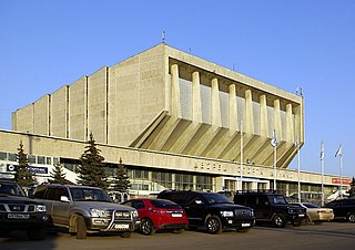
Dvorec Sporta Dinamo is an indoor sporting arena located in Moscow, Russia. The capacity of the arena is 5,000. It hosted the home games of MBC Dynamo Moscow until 2006. It was built during the preparations for the 1980 Summer Olympics, hosted by Moscow, USSR and was used as a venue of the handball tournament there. It was the home venue of Dynamo Moscow basketball team until 2006. The Dynamo Moscow volleyball team currently play their home matches here
Łąki is a village in the administrative district of Gmina Milicz, within Milicz County, Lower Silesian Voivodeship, in south-western Poland. Prior to 1945 it was in Germany.

Gatka is a village in the administrative district of Gmina Żmigród, within Trzebnica County, Lower Silesian Voivodeship, in south-western Poland. Prior to 1945 it was in Germany.

Cadogan Square is a residential square in Knightsbridge, west London, that was named after Earl Cadogan. Whilst it is mainly a residential area, some of the properties are used for diplomatic and educational purposes.
Kobyły is a village in the administrative district of Gmina Stolno, within Chełmno County, Kuyavian-Pomeranian Voivodeship, in north-central Poland.
Łapuchówka is a village in the administrative district of Gmina Narew, within Hajnówka County, Podlaskie Voivodeship, in north-eastern Poland.
Trzciniec is a village in the administrative district of Gmina Michów, within Lubartów County, Lublin Voivodeship, in eastern Poland.
Zabiele is a village in the administrative district of Gmina Niedźwiada, within Lubartów County, Lublin Voivodeship, in eastern Poland. It lies approximately 6 kilometres (4 mi) east of Niedźwiada, 15 km (9 mi) north-east of Lubartów, and 35 km (22 mi) north-east of the regional capital Lublin.
Polany is a village in the administrative district of Gmina Krempna, within Jasło County, Subcarpathian Voivodeship, in south-eastern Poland, close to the border with Slovakia. It lies approximately 5 kilometres (3 mi) south-east of Krempna, 29 km (18 mi) south of Jasło, and 68 km (42 mi) south-west of the regional capital Rzeszów.
Krasna is a village in the administrative district of Gmina Korczyna, within Krosno County, Subcarpathian Voivodeship, in south-eastern Poland. It lies approximately 8 kilometres (5 mi) north of Korczyna, 14 km (9 mi) north-east of Krosno, and 30 km (19 mi) south of the regional capital Rzeszów.
Krasna is a village in the administrative district of Gmina Stąporków, within Końskie County, Świętokrzyskie Voivodeship, in south-central Poland. It lies approximately 9 kilometres (6 mi) south of Stąporków, 17 km (11 mi) south-east of Końskie, and 22 km (14 mi) north of the regional capital Kielce.
Smugi is a settlement in the administrative district of Gmina Sośnie, within Ostrów Wielkopolski County, Greater Poland Voivodeship, in west-central Poland. It lies approximately 8 kilometres (5 mi) north of Sośnie, 15 km (9 mi) south-west of Ostrów Wielkopolski, and 107 km (66 mi) south-east of the regional capital Poznań.
Żalewo is a village in the administrative district of Gmina Szamotuły, within Szamotuły County, Greater Poland Voivodeship, in west-central Poland. It lies approximately 9 kilometres (6 mi) south-east of Szamotuły and 24 km (15 mi) north-west of the regional capital Poznań.
Pudlikajmy is a village in the administrative district of Gmina Górowo Iławeckie, within Bartoszyce County, Warmian-Masurian Voivodeship, in northern Poland, close to the border with the Kaliningrad Oblast of Russia. It lies approximately 9 kilometres (6 mi) south of Górowo Iławeckie, 21 km (13 mi) west of Bartoszyce, and 46 km (29 mi) north of the regional capital Olsztyn.
Concord is a small hamlet in the town of Concord in southern Erie County, New York, United States.

Zeche Carl is a cultural centre set up by Essen Council in a former coal mine.

Maghraoua, Médéa is a town and commune in Médéa Province, Algeria.

Dolgaec is a village in Municipality of Dolneni, central Republic of Macedonia.

Xiasha station is a Metro station of Shenzhen Metro Line 9. It opened on 28 October 2016.


