The Ob is a major river in Russia. It is in western Siberia, and with its tributary the Irtysh forms the world's seventh-longest river system, at 5,410 kilometres (3,360 mi). The Ob forms at the confluence of the Biya and Katun which have their origins in the Altai Mountains. It is the westernmost of the three great Siberian rivers that flow into the Arctic Ocean. Its flow is north-westward, then northward.

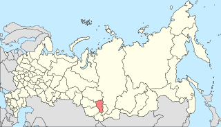
Krasnoyarsk Krai is a federal subject of Russia located in Siberia. Its administrative center is the city of Krasnoyarsk, the second-largest city in Siberia after Novosibirsk. Comprising half of the Siberian Federal District, Krasnoyarsk Krai is the largest krai in Russia, the second-largest federal subject in the country after neighboring Sakha, and the third-largest country subdivision by area in the world. The krai covers an area of 2,366,797 square kilometers (913,825 sq mi), constituting roughly 13% of Russia's total area. Krasnoyarsk Krai has a population of 2,856,971 as of the 2021 Census.

The Svir is a river in Podporozhsky, Lodeynopolsky, and Volkhovsky districts in the north-east of Leningrad Oblast, Russia. It flows westwards from Lake Onega to Lake Ladoga, thus connecting the two largest lakes of Europe. It is the largest river flowing into Lake Ladoga. The length of the Svir is 224 kilometres (139 mi), whereas the area of its drainage basin is 84,400 square kilometres (32,600 sq mi). The towns of Podporozhye and Lodeynoye Pole, as well as urban-type settlements Voznesenye, Nikolsky, Vazhiny, and Svirstroy are located at the banks of the Svir.

The Waitaki River is a large braided river in the South Island of New Zealand. It drains the Mackenzie Basin and runs 209 kilometres (130 mi) south-east to enter the Pacific Ocean between Timaru and Oamaru on the east coast. It starts at the confluence of the Ōhau and Tekapo rivers, now at the head of the artificial Lake Benmore, these rivers being fed by three large glacial lakes, Pukaki, Tekapo, and Ōhau at the base of the Southern Alps. The Waitaki flows through Lake Benmore, Lake Aviemore and Lake Waitaki, these lakes being contained by hydroelectric dams, Benmore Dam, Aviemore Dam and Waitaki Dam. The Waitaki has several tributaries, notably the Ahuriri River and the Hakataramea River. It passes Kurow and Glenavy before entering the Pacific Ocean. The River lends its name the Waitaki District on the south side of the river bank.
The Santee River is a river in South Carolina in the United States, and is 143 miles (230 km) long. The Santee and its tributaries provide the principal drainage for the coastal areas of southeastern South Carolina and navigation for the central coastal plain of South Carolina, emptying into the Atlantic Ocean about halfway between Myrtle Beach and Charleston near the community of McClellanville. The farthest headwaters are 440 miles (708 km) away on the Catawba River in North Carolina. Besides the Catawba, other principal rivers of the Santee watershed include the Congaree, Broad, Linville, Saluda and the Wateree. The watershed drains a large portion of the Piedmont regions of South and North Carolina. The Santee River is the second largest river on the eastern coast of the United States, second only to the Susquehanna River in drainage area and flow. Much of the upper river is impounded by the expansive, horn-shaped Lake Marion reservoir, formed by the 8-mile (13 km)-long Santee Dam. The dam was built during the Great Depression of the 1930s as a Works Progress Administration (WPA) project to provide a major source of hydroelectric power for the state of South Carolina.

The Lake Izvorul Muntelui, also known as Lake Bicaz, is the largest artificial lake on the interior waters of Romania; it was created after the completion of a dam built on the river Bistrița. The dam is located a few kilometers north of the town of Bicaz.

The Sihl is a Swiss river that rises near the Druesberg mountain in the canton of Schwyz, and eventually flows into the Limmat in the centre of the city of Zürich, after crossing the Zürich–Winterthur railway at Zürich HB. It has a length of 73 km (45 mi), including the Sihlsee reservoir, through which the river flows. Water is abstracted from the river at the Sihlsee, leading to decreased downstream water flows and a consequent reduction in water quality.
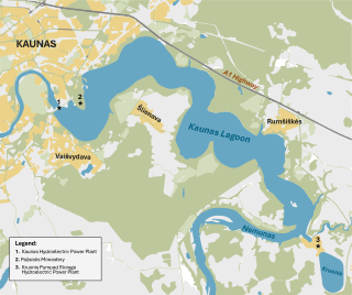
Kaunas Reservoir is the largest Lithuanian artificial lake, created in 1959 by damming the Nemunas River near Kaunas and Rumšiškės. It occupies 63.5 square kilometers, which is about 0.1% of the total territory of Lithuania. The reservoir supports the operations of the Kaunas Hydroelectric Power Plant. Its waters cover the Nemunas valley from the river's confluence with Strėva River to the dam, a distance of about 25 kilometers. At its widest, the reservoir is 3.3 kilometers across and its greatest depth is 22 meters.

The Robert-Bourassa generating station, formerly known as La Grande-2 (LG-2), is a hydroelectric power station on the La Grande River that is part of Hydro-Québec's James Bay Project in Canada. The station can generate 5,616 MW and its 16 units were gradually commissioned between 1979 and 1981. Annual generation is in the vicinity of 26500 GWh.

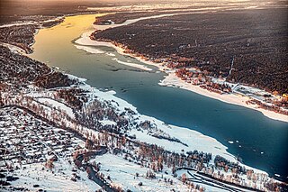
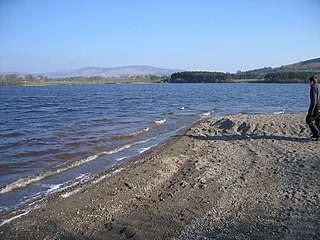
The Krasnoyarsk Dam is a 124-metre (407 ft) high concrete gravity dam located on the Yenisey River about 30 kilometres (19 mi) upstream from Krasnoyarsk in Divnogorsk, Russia. It was constructed from 1956 to 1972, and it supplies about 6,000 MW of electricity, mostly used to supply the KrAZ. Both power and aluminum plants are controlled by the RUSAL company.
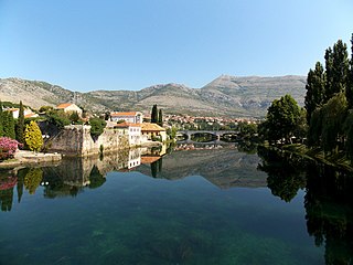
The Trebišnjica is a river in Bosnia and Herzegovina, and the right tributary of the Neretva. Before it was utilized for hydro exploitation via various hydrotechnical interventions and systems with different purposes, Trebišnjica used to be a sinking river, rising and sinking through its course before resurfacing at various places from the Neretva river below the Čapljina to the Adriatic coast, and along the coast from the Neretva Delta to Sutorina.

Donja Dubrava is a village and municipality in Međimurje County, Croatia. Donja Dubrava is the only village within the municipality. According to the 2011 census, the village had 1,920 inhabitants, mostly Croats.

Lake Qaraoun is an artificial lake or reservoir located in the southern region of the Beqaa Valley, Lebanon. It was created near Qaraoun village in 1959 by building a 61 m-high (200 ft) concrete-faced rockfill dam in the middle reaches of the Litani River. The reservoir has been used for hydropower generation, domestic water supply, and for irrigation of 27,500 ha.
Poulaphouca Reservoir, officially Pollaphuca, is an active reservoir and area of wild bird conservation in west County Wicklow, Ireland named after the Poulaphouca waterfall on its south-western end where the water exits the lake. The lake is also commonly known as the Blessington Lakes, even though there is just one.
South Central Siberia is a geographical region in North Asia, just north of the meeting point between Russia, China, Kazakhstan and Mongolia.

The Boguchany Dam is a large hydroelectric dam on the Angara River in Kodinsk, Krasnoyarsk Krai, Russia. It has an installed capacity of 2,997 MW. Construction of the power plant was completed when a ninth and final generator was brought online in January 2015.

The Cahora Bassa Dam is located in Mozambique. It is one of two major dams on the Zambezi river, the other being the Kariba. The project began to come online in 1979 after much political debate. This dam uses the Zambezi River water to generate electricity by turning turbines. That energy is then sent to South Africa. The Cahora Bassa Dam forms Cahora Bassa Lake. The dam is jointly owned by Mozambique and Portugal. From independence until 2007, eighteen percent share of the dam and lake was owned by Mozambique and eighty-two percent by Portugal. Portugal sold down its share to 15 percent in 2007. The Cahora Bassa Dam is the largest hydroelectric power plant in southern Africa and the most efficient power generating station in Mozambique.

Trebinjsko Lake is an artificial lake of Bosnia and Herzegovina. It is located in the municipality of Trebinje. it was created as a reservoir by damming the Trebišnjica river just few kilometers upstream from Trebinje town with a facility and dam, Trebinje II Hydroelectric Power Station.

Soboth reservoir is an artificial reservoir in Austria created in 1990 when an embankment dam on the Feistritz stream was created to power the Koralpe hydroelectric power plant. The artificial lake is located in the Koralpe mountain range, near the Soboth village, beside the road connecting Lavamünd and Graz, close to the Soboth Pass near the Slovenian-Austrian border. Its elevation is about 1080 m above sea level. Its natural drainage basin has an area of 29.7 km². The reservoir is around 2 km long and up to 500 m wide, has a surface area of 0.8 km2 and is up to 80 m deep. In summer, the lake is a popular place for swimming due to its clean water, cooler climate due to its high elevation, and natural surroundings consisting of spruce-covered hills.


