Kreuz Kaiserberg

Last updated
Kreuz Kaiserberg
Kreuz Kaiserberg Duisburg Still-Leben Ruhrschnellweg.JPG
The Ruhr.2010 "Still-Leben" event at the interchange
Kreuz Kaiserberg
Location
Duisburg, Germany
Coordinates 51°26′30″N6°48′20″E / 51.44167°N 6.80556°E / 51.44167; 6.80556 Coordinates: 51°26′30″N6°48′20″E / 51.44167°N 6.80556°E / 51.44167; 6.80556
Roads at
junction
Construction
Type Spaghetti Junction
Lanes2x3/2x4
Opened1966/1969/1974

The Kreuz Kaiserberg (German: Autobahnkreuz Kaiserberg) is a spaghetti junction in the Metropolitan region Rhein-Ruhr in the German state of Northrhine-Westphalia.

Contents

The interchange forms the connection between the A3, which runs from the Dutch border near Elten via Oberhausen and Frankfurt am Main to the Austrian border south of Passau, and the A40 (Ruhrschnellweg) from Venlo to Dortmund. [1]

Geography

The Kreuz Kaiserberg is located in the city of Duisburg and is called after the 75-metre-high Kaiserberg there. To the west lies the district of Duissern and south of the interchange is the Duisburg Zoo. North of the interchange are the River Ruhr and the Duisburg harbour. Nearby cities are Mülheim an der Ruhr and Oberhausen. The interchange is approximately 3 km east of the city centre of Duisburg.

History

The building of the interchange began in October 1966. It was opened to traffic in stages between April and June 1969; the connection on the eastern side to the Ruhrschnellweg (previously known as B60) opened at the same time. The western section of what is now the A40, between the Kreuz Duisburg  [ de ] and the A3, was completed in 1974. [2]

Until April 1992, the A40 east of the Kreuz Kaiserberg was designated the A430 and west of it the A2. To the north, the A3 and the A2 were combined as far as the Kreuz Oberhausen  [ de ]. Until 1992, the official name of the intersection was Duisburg-Kaiserberg. The stretch of autobahn and the intersection were both renamed because reuse of the same name (in this case for the Duisburg-Kaiserberg exit and the Duisburg-Kaiserberg intersection) and double numbering of a section of motorway (A2/A3) are not permitted.

In May 2010, the interchange was the scene of an unusual accident: a car travelling over one of its bridges broke through the concrete barrier and fell onto the A3 below. The car's 46-year-old driver was severely injured and had to be rescued by the fire brigade. The driver of another car travelling on the A3 was slightly injured, as he was unable to brake in time and crashed into the fallen car. [3]

On 18 July 2010, a 60 km (37 mi) stretch of the A40 between Dortmund and Duisburg was closed for the Ruhr.2010 European Capital of Culture project Still-Leben ("Still Life"). As part of that event, several hundred thousand people gathered at Kreuz Kaiserberg to celebrate Ruhr.2010. In the centre of the intersection was an installation by German-based American artist Rita McBride modelled on the Delicate Arch in Utah, USA. The gathering has been described as "the most beautiful traffic jam Kreuz Kaiserberg has ever had". It was the first time since 1973 that pedestrians had been permitted to roam the interchange without being endangered by traffic. [4] [5]

Building form

As a "spaghetti junction", the interchange was built in an unusual way. Due to the narrow angle in which the motorways cross, the ramps had to be built in a small space and all lie south of the main bridge in the interchange.

Road configuration

Near the interchange the A3 is a 2x3 lane motorway, but between the interchange on- and off-ramps is a 2x2 motorway. On the Essen side, the A40 is 2x2, but on the Duisburg side it has been expanded to 2x3. In addition, since 2014 the A40 has been further expanded between the Kaiserberg and Duisburg interchanges, only in the direction of Essen, to 4 lanes without hard shoulder. All the ramps are single-lane, except those that lead in multiple directions. In their transport planning document (Bundesverkehrswegeplan), the German government has designated widening the A40 to 2x3 lanes on the Essen side as highly urgent.

Traffic near the interchange

Approximately 205,000 vehicles passed through the interchange on a daily basis in 2010.

FromToAverage daily trafficPercentage of heavy traffic [6]
AS Oberhausen-Lirich (A 3)AK Kaiserberg126.80013,1 %
AK KaiserbergAS Duisburg-Wedau (A 3)97.60011,3 %
AK Duisburg (A 40)AK Kaiserberg101.30012,8 %
AK KaiserbergAS Duisburg-Kaiserberg (A 40)85.3008,3 %

The portion of the A40/A44 between the Kreuz Kaiserberg and Kreuz Werl is traditionally one of the most congested sections of Autobahn in Germany. [7]

Related Research Articles

Ruhr Place in North Rhine-Westphalia, Germany

The Ruhr, also referred to as the Ruhr area, sometimes Ruhr district, Ruhr region, or Ruhr valley, is a polycentric urban area in North Rhine-Westphalia, Germany. With a population density of 2,800/km2 and a population of over 5 million (2017), it is the largest urban area in Germany. It consists of several large cities bordered by the rivers Ruhr to the south, Rhine to the west, and Lippe to the north. In the southwest it borders the Bergisches Land. It is considered part of the larger Rhine-Ruhr metropolitan region of more than 10 million people, which is among the largest in Europe, behind only London and Paris.

Duisburg City in North Rhine-Westphalia, Germany

Duisburg is a city in the Ruhr metropolitan area of the western German state of North Rhine-Westphalia. Lying on the confluence of the Rhine and the Ruhr rivers in the center of the Rhine-Ruhr Region, Duisburg is the 5th largest city in North Rhine-Westphalia and the 15th-largest city in Germany.

Spaghetti junction Intertwined road traffic interchange

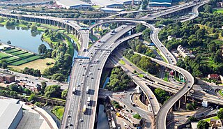
Spaghetti junction is a nickname sometimes given to a complicated or massively intertwined road traffic interchange that is said to resemble a plate of spaghetti. Such interchanges may incorporate a variety of interchange design elements in order to maximize connectivity.

Bundesautobahn 1 Federal motorway in Germany

Bundesautobahn 1 is an autobahn in Germany. It runs from Heiligenhafen in Schleswig-Holstein to Saarbrücken, a distance of 749 km (465 mi), but is incomplete between Cologne and Trier. B 207 continues north from Heiligenhafen to Puttgarden, at the end of the island of Fehmarn, with a ferry to Rødby, Denmark.

Bundesautobahn 2

Bundesautobahn 2 is an autobahn in Germany that connects the Ruhr area in the west to Berlin in the east. The A 2 starts at the junction with the A3 near the western city of Oberhausen, passes through the north of the Ruhr valley, through the Münsterland and into Ostwestfalen, crossing the former inner German border and continuing through the Magdeburger Börde to merge into the Berliner Ring shortly before reaching Berlin. Major cities such as Magdeburg, Braunschweig, Hannover and Dortmund are situated very close to the A 2. The A 2 is one of the most important autobahns, connecting several large industrial areas with each other.

Bundesautobahn 40

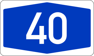
Bundesautobahn 40, is one of the most used Autobahns in Germany. It crosses the Dutch-German border as a continuation of the Dutch A67 and crosses the Rhine, leads through the Ruhr valley toward Bochum, becoming B 1 (Bundesstraße 1) at the Kreuz Dortmund West and eventually merging into the A 44 near Holzwickede.

Bundesautobahn 3 Autobahn in Germany

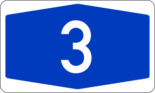
Bundesautobahn 3 is an autobahn in Germany running from the Germany-Netherlands border near Wesel in the northwest to the Germany-Austria border near Passau.

Bundesautobahn 61

Bundesautobahn 61 is an autobahn in Germany that connects the border to the Netherlands near Venlo in the northwest to the interchange with A 6 near Hockenheim. In 1965, this required a redesign of the Hockenheimring.

Bundesautobahn 4 Federal motorway in Germany

Bundesautobahn 4 is an autobahn that crosses Germany in a west–east direction. The western segment has a length of 156 km (97 mi), the part in the east is 429 km (267 mi) long. Works to continue the A 4 are in progress, but currently no plans exist to fill the gap completely.

Bundesautobahn 45

Bundesautobahn 45 is an autobahn in Germany, connecting Dortmund in the west with Aschaffenburg in the southwest. It is colloquially known as the Sauerlandlinie as it runs through the hilly, rural Sauerland region between Hagen and Siegen. The A45 has many bridges to cross valleys, the highest of which is the Sichter Valley bridge between Lüdenscheid and Meinerzhagen at 530 metres above mean sea level. It is mostly two lanes each way with frequent climbing lanes between Dortmund-Hafen and the Gambacher Kreuz intersection. In March 2013 30 people were injured in a pile-up on the A45.

Line S1 is a S-Bahn line on the Rhine-Ruhr network. It is operated by DB Regio. It runs from Dortmund via Bochum and Essen to Duisburg. From there it travels south to Düsseldorf and Hilden before continuing to Solingen. It is operated on weekdays at 15-minute intervals between Dortmund Hbf and Essen Hbf, at 20-minute intervals between Düsseldorf Hbf and Solingen and at 30-minute intervals between Düsseldorf and Essen, using coupled sets of class 422 four-car electrical multiple units.

Welver–Sterkrade railway

The Welver–Sterkrade railway is a former through railway line from the Westphalian town of Welver to Sterkrade in the western Ruhr region in Germany, which is now broken into four disconnected sections. Because its route ran along the Emscher river it was known as the Westphalian Emscher Valley Railway.

Rhein-Emscher-Express Regional-Express service in North Rhine-Westphalia, Germany

The Rhein-Emscher-Express is a Regional-Express service in the German state of North Rhine-Westphalia (NRW), running from Düsseldorf via Duisburg, Gelsenkirchen and Dortmund to Hamm. It connects with the rest of the regional rail network of NRW in Düsseldorf, Duisburg, Oberhausen, Wanne-Eickel, Dortmund and Hamm. In addition, it connects in Düsseldorf, Duisburg, Oberhausen, Dortmund and Hamm with long-distance services.

Mülheim-Styrum station

Mülheim-Styrum station is located in the district of Styrum in the German city of Mülheim in the German state of North Rhine-Westphalia. It is on the Witten/Dortmund–Oberhausen/Duisburg line and is classified by Deutsche Bahn as a category 3 station.

The Mülheim-Heißen–Oberhausen-Osterfeld Nord railway is a line that formerly ran continuously in the western Ruhr region from Heißen to Osterfeld in the German state of North Rhine-Westphalia.

Osterath–Dortmund Süd railway

The Osterath–Dortmund-Süd railway is a historically significant line in the German state of North Rhine-Westphalia. Parts of it are closed, much of it is now used for freight only, but several sections are still used for Regional-Express, Regionalbahn or Rhine-Ruhr S-Bahn services.

The Bochum–Essen/Oberhausen railway was built by the Bergisch-Märkische Railway Company to the north of its main line through the central Ruhr to tap traffic from mines and factories in the northern Ruhr region, which is now in the German state of North Rhine-Westphalia.

The Kreuz Hegau is a Directional T interchange/Half-Cloverleaf interchange in the German state of Baden-Württemberg.

The Kreuz Hilden is a cloverleaf interchange in the German state North Rhine Westphalia.

Gambacher Kreuz

The Gambacher Kreuz is a cloverleaf interchange in Hesse, Germany where the A5 Autobahn from Basel to Bad Hersfeld intersects the A45 between Dortmund and Aschaffenburg. It constitutes a node in the primary route between the Rhein-Main metropolitan area and the eastern end of the Ruhr valley.

References

  1. "AK Kaiserberg". Autobahnkreuze & Autobahndreiecke in Deutschland. 2011. Retrieved 2013-05-19.[ self-published source ]
  2. Schreiber, Andreas (1987). "Autobahn — Geschichtliches und Philosophisches". im blickpunkt (in German). Vol. 14, no. 1. LV Rheinland Köln.
  3. "Schlimmer Unfall: Auto stürzt von Autobahnbrücke auf A3" [Bad accident: Car plunges from autobahn bridge onto A3]. Die Welt . 3 May 2010. Retrieved 26 December 2015.
  4. Staff writer (16 July 2010). "Schlagader des Reviers steht still". Kölner Stadt-Anzeiger . Retrieved 29 December 2015.
  5. Schwerdtfeger, Christian (6 August 2013). "Geheimnisvolle Orte (7): Als der Spaghetti-Knoten autofrei war" [Mysterious Places (7): When the spaghetti junction was carfree]. Rheinische Post (RP Online). Retrieved 26 December 2015.
  6. "Manuelle Verkehrszählung BAB 2010" (pdf, 336 KB). BASt Statistik. 2010. Archived from the original on 2013-03-23. Retrieved 2012-11-05.
  7. Staff writer (16 October 2009). "Koalition will Standstreifen bei Stau freigeben" [Coalition wants the release of the emergency lane during congestion]. Die Welt . Retrieved 26 December 2015.

Further reading