
Mettur is an industrial and tourist town located in the Salem district in the state of Tamil Nadu, India. It is best known for the Mettur Dam which is the largest dam in south India.

Bhavani is a Municipality in Erode District, Tamil Nadu, India. It is located at the northern periphery of Erode City Municipal Corporation and is around 105 km (65 mi) from Coimbatore and 60 km (37 mi) from Tiruppur and Salem. Bhavani is also known as "Carpet City" as it is known for its carpet industry; blankets and carpets manufactured in the town are known as Bhavani Jamakkalam. As of 2011, the town covers an area of 2.17 square kilometres (0.84 sq mi) and has a population of 39,225. It is a grade II municipality.

Bilaspur is a town and a municipal council in Bilaspur district in the Indian state of Himachal Pradesh.
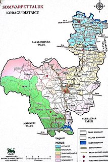
Somwarpet is a panchayat town in Coorg district in the Indian state of Karnataka. It is the main town of the Somwarpet taluk, in the north-east of the district. Second highest, Administration Town in Karnataka in terms of Altitude. The main crops grown in the area are coffee and spice crops such as cardamom, peppers, oranges, ginger and vegetables.

Kushalanagara or Kushalnagar is a city located in the Kodagu district of the Indian state of Karnataka. Surrounded by Kaveri river, it is the gateway to Kodagu district. It also serves as the headquarters of Kushalanagar Taluk. By population, Kushalanagar is the third largest town in the district after Madikeri and Virajpet. Kushalnagar is an important commercial centre in Kodagu.

The Hemavati is a river in Karnataka, southern India, an important tributary of the Kaveri.

Bilagi is a panchayat town and taluka in the Bagalkot district of Karnataka, India. While only 19.5 km from the district headquarters of Bagalkote, the route by road is 30 km. The main occupation of people in this taluka is agriculture. Most of the farmers grow sugarcane.

Kanakapura is a city and the headquarters and A city in the Ramanagara district of Karnataka on the banks of the Arkavathi river and the administrative center of the taluk of the same name. Previously belonged to Bangalore Rural District. It was formerly the largest constituency in the country. The taluk is very widespread (1,553 km2 [600 sq mi]). It is located among the lush green forests of the state of Karnataka. The town is a tourism hotspot and an often visited tourist favorite in the entire state of Karnataka, as it has something for everyone ranging from avid trekkers to history buffs and wildlife enthusiasts.The forest area in this taluk is very wide and about half of the Bannerghatta National Park is located in our Kanakapura area.Kodihalli wildlife range and harohalli wildlife range its division.The Kaveri Wildlife Sanctuary consists of two main zones namely the Sangam Wildlife range, the Mugur Wildlife range

Arkalgud, also known as Arakalagudu is a panchayat town and is one among the eight taluks of Hassan district in the state of Karnataka, India. It is situated 30 km from Hassan, 181 km from Mangalore and 195 km from Bangalore. The river Hemavati forms the entire northern boundary of the Taluk; river Kaveri runs through a portion of the south. It is well connected by road to many towns and cities of Karnataka. Holenarasipura is the nearest railway station to Arakalgud taluk and the nearest airport is in Bangalore.
Dehra Gopipur is a town, a Municipal Council, and a Tehsil in Kangra district in the state of Himachal Pradesh, India. The River Beas divides the town into Dera & Gopipur. The town of Dehra is as recent as mid 15th century when foreign invaders used this place as a dera (camp) for their expedition to hill states. British made the evolving town as the tehsil in year 1868. The official name of the town during British Raj was Dera.

Gudibande is a city in Chikkaballapur District in the Indian State of Karnataka.
Haliyal is a town in Uttara Kannada in the Indian state of Karnataka. It is the headquarters town for Haliyal Taluk. It can be classified as a main-road town. It has fort called "killa" to see tourist in town area only. It has various tourist places like ambikanagar Sykes point, dandeli garden,featured page of Haliyal on Instagram,Facebook - @haliyal_models_n_nature
Kalaghatagi is an administrative division, or Taluka, in the Dharwad district of the Indian state of Karnataka.
Munirabad, also called Huligi, is a Town in the Koppal district in the Indian state of Karnataka.

Sitarganj is a city and a municipal board in Udham Singh Nagar district in the Indian state of Uttarakhand. Now it is home to the Integrated Industrial Estate Sitarganj (IIE) being developed by State Industrial Development Corporation of Uttarakhand(SIDCUL).

Thirukattupalli is a panchayat town near Thiruvaiyaru in Thanjavur district in the Indian state of Tamil Nadu. The economy of this town is majorly based on the agricultural lands of the surrounding villages. Its nearby major cities include Thanjavur and Trichy. Modes of transportation to these cities include regular daily bus services and Budalur Railway Station. Sir P. S. Sivaswami Iyer Higher Secondary School located at the heart of this town serves as the alma-mater for nearly all locals.

Tirumakudalu Narasipura the temple city of Karnataka, commonly known as T. Narasipura or T.N. Pura, is a town in Mysore district in the Indian state of Karnataka. The first name refers to the land at the confluence, (trimakuta in Sanskrit at the confluence of the Kaveri, Kabini and Spatika Sarovara.

Turuvekere is a panchayat town and Taluk in Tumkur district in the Indian state of Karnataka.

Chakia (Devanagari:चकिया) is a small town and the sub-divisional headquarters of Chakia Tehsil in the District of Chandauli of Varanasi Division in the northern Indian state of Uttar Pradesh.
Sagara is a city located in the Indian state of Karnataka and it is also a sub divisional and a taluk headquarters. Located in the Sahyadri Mountain range on the banks of river Varada, it is known for its proximity to Jog Falls and to the historical places of Ikkeri, Keladi and Varadamoola. The river Varada originates near Varada-moola. Sagara subdivision consists of Sagara, Soraba, Hosanagara and Shikaripur taluks.
