Kronborg Glacier

Last updated
Kronborg Glacier
Kronborg Gletscher
US Navy 040809-N-0331L-006 Lt. Cmdr. Christopher Blow, left, and Lt. Cmdr. Steve Dial examine the wreckage of a Navy P-2V Neptune aircraft that crashed over Greenland in 1962.jpg
US Navy personnel examining the wreckage of a Navy P-2V Neptune aircraft in the Kronborg Glacier with the Wiedemann Range in the background.
Greenland edcp relief location map.jpg
Blue pog.svg
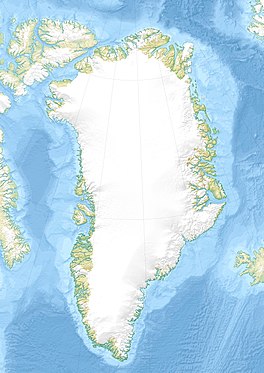
Location within Greenland
Type Valley glacier
Location Greenland
Coordinates 68°45′N28°37′W / 68.750°N 28.617°W / 68.750; -28.617
Terminus Ravn Fjord
Denmark Strait

Kronborg Glacier (Danish : Kronborg Gletscher) is a glacier on the east coast of the Greenland ice sheet. [1] It is named after Kronborg Castle in Denmark. Administratively this glacier is part of the Sermersooq Municipality. [2] The area surrounding the Kronborg Glacier is remote and uninhabited.
Contents

History

In 1962, a VP-5 Lockheed P-2 Neptune on a routine patrol mission crashed into the slope of the Kronborg Glacier in unknown circumstances, killing all twelve men aboard. The place where the plane had crashed was finally discovered in 1966 when four geologists found the remains, but it was not until 2004 that the US Navy recovered all the crew remains and memorialized the deceased at the crash site. [3]

Geography

The Kronborg Glacier is a non-surge type valley glacier that does not drain the Greenland ice sheet directly, but flows partly from it across mountainous areas in a roughly north–south direction. It separates the Ejnar Mikkelsen Range in the west from the Borgtinderne in the east. Further south it separates the Watkins Range and the Lilloise Range in the west from the Wiedemann Range in the east, [1] until its terminus at the head of the Ravn Fjord in the East Greenland coast. [4]

A fast-flowing glacier, it is similar in structure to the neighbouring Christian IV Glacier. The Rosenborg Glacier is a smaller glacier flowing between both. [5]

Defense Mapping Agency map of Greenland sheet showing the Kronborg Glacier. Operational Navigation Chart C-13, 3rd edition.jpg
Defense Mapping Agency map of Greenland sheet showing the Kronborg Glacier.

See also

Further reading

Related Research Articles

<span class="mw-page-title-main">Uummannaq Fjord</span> Fjord system in Greenland

Uummannaq Fjord is a large fjord system in the northern part of western Greenland, the largest after Kangertittivaq fjord in eastern Greenland. It has a roughly south-east to west-north-west orientation, emptying into the Baffin Bay in the northwest.

<span class="mw-page-title-main">Russell Glacier (Greenland)</span> Glacier in Greenland

Russell Glacier is a glacier in the Qeqqata municipality in central-western Greenland. It flows from the Greenland ice sheet in the western direction. The front of the glacier is located 25 km (16 mi) east of Kangerlussuaq. It is active, advancing 25 m (82 ft) every year, and, due to easy access from Kangerlussuaq, it remains a popular place for tourists to visit.

<span class="mw-page-title-main">Watkins Range</span> Mountain range in Greenland

The Watkins Range is Greenland's highest mountain range. It is located in King Christian IX Land, Sermersooq municipality.

<span class="mw-page-title-main">Waltershausen Glacier</span>

Waltershausen Glacier is one of the major glaciers in Greenland. It has its terminus on the east coast of the Greenland ice sheet.

<span class="mw-page-title-main">Odinland</span> Peninsula in southeastern Greenland

Odinland, also Odinsland in the Defense Mapping Agency Greenland Navigation charts, is a peninsula in the King Frederick VI Coast, southeastern Greenland. It is a part of the Sermersooq municipality.

<span class="mw-page-title-main">Christian IV Glacier</span> Glacier in Greenland

Christian IV Glacier is a large glacier on the east coast of the Greenland ice sheet. It is named after King Christian IV of Denmark. Administratively this glacier is part of the Sermersooq Municipality. The area surrounding Christian IV Glacier is uninhabited.

<span class="mw-page-title-main">Lindbergh Range</span> Mountain range in Greenland

The Lindbergh Range or Lindbergh Nunataks is a mountain range in King Christian IX Land, eastern Greenland. Administratively the range is part of the Sermersooq Municipality.

<span class="mw-page-title-main">Hutchinson Glacier</span>

The Hutchinson Glacier is a large active glacier on the east coast of the Greenland ice sheet.

<span class="mw-page-title-main">Inglefield Gulf</span> Fjord in northwestern Greenland

Inglefield Gulf or Inglefield Fjord is a fjord in northwestern Greenland. To the west, the fjord opens into the Baffin Bay. Administratively it belongs to the Avannaata municipality.

<span class="mw-page-title-main">Heilprin Glacier</span>

Heilprin Glacier, is a glacier in northwestern Greenland. Administratively it belongs to the Avannaata municipality.

<span class="mw-page-title-main">Farquhar Glacier</span>

Farquhar Glacier, is a glacier in northwestern Greenland. Administratively it belongs to the Avannaata municipality.

<span class="mw-page-title-main">Melville Glacier (Greenland)</span> Glacier in Greenland

Melville Glacier, is a glacier in northwestern Greenland. Administratively it belongs to the Avannaata municipality.

<span class="mw-page-title-main">Hart Glacier (Greenland)</span> Glacier in northwestern Greenland

Hart Glacier, is a glacier in northwestern Greenland. Administratively it belongs to the Avannaata municipality.

<span class="mw-page-title-main">Sharp Glacier (Greenland)</span> Glacier in Greenland

Sharp Glacier, is a glacier in northwestern Greenland. Administratively it belongs to the Avannaata municipality.

<span class="mw-page-title-main">Lilloise Range</span> Mountain range in eastern Greenland

The Lilloise Range or Lilloise Mountains is a mountain range in King Christian IX Land, eastern Greenland. Administratively this range is part of the Sermersooq Municipality.

Frederiksborg Glacier is a glacier on the east coast of the Greenland ice sheet. It is named after Frederiksborg Castle in Denmark.

<span class="mw-page-title-main">Rimfaxe (glacier)</span>

Rimfaxe is a glacier of the King Frederick VI Coast in the Sermersooq municipality, southeastern Greenland.

<span class="mw-page-title-main">Wiedemann Range</span>

The Wiedemann Range is a mountain range in King Christian IX Land, eastern Greenland. Administratively this range is part of the Sermersooq Municipality.

<span class="mw-page-title-main">Bernstorff Glacier</span> Glacier in Greenland

Bernstorff Glacier, is a glacier in the King Frederick VI Coast, Sermersooq, southeastern Greenland.

<span class="mw-page-title-main">Storebjørn Glacier</span>

Storebjørn Glacier, is a glacier in the King Frederick VI Coast, Sermersooq, southeastern Greenland.

References

  1. 1 2 "Kronborg Gletscher". Mapcarta. Retrieved 6 July 2019.
  2. Google Earth
  3. The fifty-year saga of the aircraft LA-9
  4. Prostar Sailing Directions 2005 Greenland and Iceland Enroute, p. 110
  5. Brooks, C.K. Geomorphological Observations at Kangerdlugssuaq, East Greenland, Greenland Geoscience, Vol 1, 1979 p. 16