
Kristiansand Region is a statistical metropolitan region in the counties of Vest-Agder and Aust-Agder in southern Norway. It is centered on the city of Kristiansand. The region consist of 6 municipalities in the centre of Southern Norway. Vennesla, Songdalen, and Birkenes are inland municipalities while Kristiansand, Søgne, and Lillesand are coastal municipalities. Kristiansand is the largest municipality in population in the region and Birkeland is the largest in area.

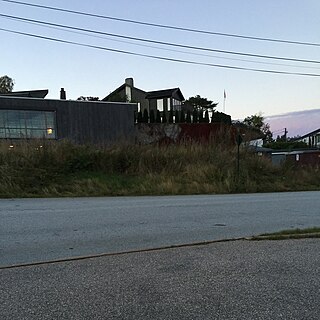
Flekkerøy or Flekkerøya is an island and residential district in Kristiansand municipality in Vest-Agder county, Norway. The district is located within the borough of Vågsbygd, and it consists of 4 main neighborhoods: Berge/Andås, Kjære, Lindebø/Skålevik, and Mæbø/Høyfjellet. The district covers all of the island of Flekkerøya which lies within the city of Kristiansand. Since 1989, the island has been connected to the mainland through the Flekkerøy Tunnel, a 2,320-metre (7,612 ft) long subsea road tunnel. The island has 3,632 inhabitants. Flekkerøy Church is located on the island.

Vågsbygd is a borough and district in the city of Kristiansand in Vest-Agder county, Norway. It is the largest borough and district in Kristiansand. Until 1965, Vågsbygd was a part of Oddernes municipality. The borough includes the districts of Flekkerøy, Voiebyen, Vågsbygd/Augland, and Slettheia. The Kristiansand Cannon Museum on Kroodden is an authentic fortress from World War II.
Hannevika or Hannevig / Hannevik is a neighbourhood in the city of Kristiansand in Vest-Agder county, Norway. It is located in the borough of Grim and in the district of Tinnheia. The neighborhood is located along the European route E39 highway and the start of Norwegian County Road 456. Hannevika is a large industrial area. Glencore and Hennig-Olsen Iskremfabrikk are the two largest industries located there. Hannevika is located southeast of Eigevannskollen, northeast of Kartheia, and south of Kolsberg.
Kolsberg is a neighbourhood in the city of Kristiansand in Vest-Agder county, Norway. It is located in the borough of Grim. The apartments at Kolsberg in the hills can be seen from the European route E39 highway passing to the south.

Tømmerstø is a neighbourhood in the city of Kristiansand in Vest-Agder county, Norway. It's located in the borough of Oddernes and in the district of Randesund. The neighborhood of Odderhei lies to the northwest, Holte and Frikstad lie to the northeast, and Kongshavn lies to the southeast.
Ternevig is a neighbourhood in the city of Kristiansand in Vest-Agder county, Norway. The neighborhood is located in the borough of Vågsbygd and in the district of Voiebyen. Ternevig is northeast of Møvik, southeast of Voie, east of Møviklia, and west of the ocean and the island of Andøya. There is a small hospital located in Ternevig serving the borough of Vågsbygd. There is also a marina located in this neighborhood.

Voie is a neighbourhood in the city of Kristiansand in Vest-Agder county, Norway. The neighborhood is located in the borough of Vågsbygd and in the district of Voiebyen. Voie lies along Norwegian County Road 456 and County Road 457. The only road to the island of Andøya goes past the neighborhood of Voie. It lies northwest of Møvik and northeast of Steindalen.
Kongshavn is a neighbourhood in the city of Kristiansand in Vest-Agder county, Norway. It's located in the borough of Oddernes and in the district of Randesund. The neighborhood of Frikstad lies to the north and Tømmerstø lies to the northwest. Kongshavn Pier is a large harbor with connections to islands outside of Randesund.
Holte is a neighbourhood in the city of Kristiansand in Vest-Agder county, Norway. It's located in the borough of Oddernes and in the district of Randesund. The neighborhood of Tømmerstø lies to the south and Frikstad lies to the east. Holte Junior High is the only junior high in Randesund.
Spinneren is a neighbourhood in the city of Kristiansand in Vest-Agder county, Norway. The neighborhood is located in the borough of Vågsbygd and in the district of Voiebyen. Spinneren is located along the coast, south of Møvik and north of Kroodden.
Skutevika is a neighbourhood in the city of Kristiansand in Vest-Agder county, Norway. The neighborhood is located in the borough of Vågsbygd and in the district of Voiebyen. Skutevika is north of Kroodden, south of Møviklia, east of Steindalen, and west of Spinneren.
Steindalen is a neighbourhood in the city of Kristiansand in Vest-Agder county, Norway. The neighborhood is located in the borough of Vågsbygd and in the district of Voiebyen. Steindalen is north of Kroodden, south of Voieåsen, east of Voietun, and west of Møviklia.
Voieåsen is a neighbourhood in the city of Kristiansand in Vest-Agder county, Norway. The neighborhood is located in the borough of Vågsbygd and in the district of Voiebyen. Voieåsen is north of Møviklia, south of Voie, east of Voielia, and west of Møvik.
Voielia is a neighbourhood in the city of Kristiansand in Vest-Agder county, Norway. The neighborhood is located in the borough of Vågsbygd and in the district of Voiebyen. Voielia is north of Voietun, south of Rådyr, east of Bråvann, and west of Voieåsen.
Rådyr is a neighbourhood in the city of Kristiansand in Vest-Agder county, Norway. The neighborhood is located in the borough of Vågsbygd and in the district of Voiebyen. The neighborhood of Rådyr is north of Voielia, south of Kjos Haveby, east of Bråvann, and west of Kjosbukta.
Elisenhøy is a neighbourhood in the city of Kristiansand in Vest-Agder county, Norway. It is located in the borough of Grim and in the district of Grim. It is located on the south side of the Norwegian National Road 9, east of Klappane and Grim torv, northwest of Fagervoll, and south of Krossen.
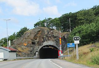
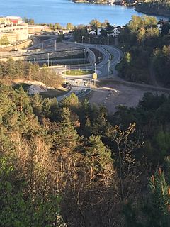
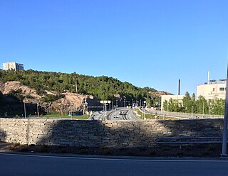
The Flekkerøy Tunnel is a subsea road tunnel on the county road 457 in the municipality of Kristiansand in Vest-Agder county, Norway. The tunnel runs under the strait between Kroodden on the mainland and the island of Flekkerøya. The tunnel is 2,321-metre (7,615 ft) long, it reaches a depth of 101 metres (331 ft) below sea level, and the maximum gradient is 10%. Construction started on the Flekkerøy tunnel on 1 August 1988. The breakthrough in the tunnel was on 6 March 1989 and the tunnel was opened on 15 August 1989. It replaced a ferry connection between Møvik in mainland Kristiansand and Lindebøkilen on the island of Flekkerøy.

Flekkerøy Church is a parish church in Kristiansand municipality in Vest-Agder county, Norway. It is located in the village of Mæbø on the island of Flekkerøy in the city of Kristiansand. The church is part of the Flekkerøy parish in the Kristiansand arch-deanery in the Diocese of Agder og Telemark. The white, concrete church was built in 1960 using plans by the architect Gabriel Tallaksen. The church seats about 375 people. There are plans in place to build a large addition to the church in 2019 that will roughly double the capacity of the church.


