Krumbach, Lower Austria

Last updated
Krumbach
Krumbach (NO) - Westsudwestansicht.JPG
Southwest view of Krumbach
AUT Krumbach COA.jpg
Austria adm location map.svg
Red pog.svg
Krumbach
Location within Austria
Coordinates: 47°31′27″N16°11′31″E / 47.52417°N 16.19194°E / 47.52417; 16.19194 Coordinates: 47°31′27″N16°11′31″E / 47.52417°N 16.19194°E / 47.52417; 16.19194
Country Austria
State Lower Austria
District Wiener Neustadt-Land
Government
   Mayor Freiler Josef (ÖVP)
Area
[1]
  Total43.91 km2 (16.95 sq mi)
Elevation
533 m (1,749 ft)
Population
 (2018-01-01) [2]
  Total2,316
  Density53/km2 (140/sq mi)
Time zone UTC+1 (CET)
  Summer (DST) UTC+2 (CEST)
Postal code
2851
Area code 02647
Vehicle registration WB
Website www.krumbach-noe.at

Krumbach is a market town in southern Lower Austria, Austria. It is part of the landscape Bucklige Welt.
Contents

History

Krumbach Castle Krumbach (NO) - Schloss, Ostansicht.JPG
Krumbach Castle

Archaeological artifacts from the Stone Age, the Bronze Age and the Roman times have been found in the area. In 1182, Krumbach was mentioned for the first time in writing. The present castle Schloss Krumbach was erected in the 13th century. In 1394 Hans von Chrumbach, the last Lord of Krumbach, died and left the castle to his maternal uncle.

In the 17th and 18th centuries, the plague and the cholera affected Krumbach. In 1854, it became a market town. In 1884, Krumbach opened a fire station. It has a post office, a school (Volksschule Krumbach), a high school (Hauptschule Krumbach) and a church.

Mayors since 1945

1945Anton Schwarz
1945–1946Johann Gebhart
1946–1950Ernst Bauer
1950–1963Florian Freiler
1963–1979Ernst Blochberger
1979–1990Friedrich Gamauf
1990–1995Otmar Gebhart
1995–1997Friedrich Trimmel
1997-Josef Freiler

Coat of arms

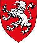
The coat of arms shows a silver lion with a chain around its neck. The crest is colored red. This has been the town's seal since January 19, 1957.

Sites of interest

Parish church in Krumbach Krumbach (NO) - Kirche.JPG
Parish church in Krumbach

Buildings:

Parks:

Related Research Articles

Mauthausen, Upper Austria Place in Upper Austria, Austria

Mauthausen is a small market town in the Austrian state of Upper Austria. It is located at about 20 kilometres east of the city of Linz. The town lies on the banks of the Danube river, opposite the town of Enns, where the major Danube tributary of Enns joins it.

Bad Fischau-Brunn Place in Lower Austria, Austria

The market town of Bad Fischau-Brunn is an Austrian municipality in the district of Wiener Neustadt-Land in Lower Austria. It is situated some 50 km south of Vienna at the edge of Viennese Basin.

Bruck an der Leitha Place in Lower Austria, Austria

Bruck an der Leitha is a city in Lower Austria, Austria at the border to the Burgenland, which is marked by the Leitha river.

Lanzenkirchen Place in Lower Austria, Austria

Lanzenkirchen is a market town in the district of Wiener Neustadt-Land in the Austrian state of Lower Austria.

Lichtenwörth Place in Lower Austria, Austria

Lichtenwörth is a market town in Austria. It is situated by the rivers Leitha and Warme Fischa. The market town has a kindergarten school, an elementary school and a high school. It also has a music school.

Rohrau, Austria Place in Lower Austria, Austria

Rohrau is a village in the state of Lower Austria. The name comes from two German words: Rohr (reed) and Au. South of the village is a riparian forest and a swamp covered with reed.

Laxenburg Place in Lower Austria, Austria

Laxenburg is a market town in the district of Mödling, in the Austrian state of Lower Austria. Located about 20 km (12 mi) south of the Austrian capital Vienna, it is chiefly known for the Laxenburg castles, which, beside Schönbrunn, served as the most important summer retreat of the Habsburg monarchs.

Freistadt Place in Upper Austria, Austria

Freistadt is a small Austrian town in the state of Upper Austria in the region Mühlviertel. With a population of approximately 7,500 residents, it is a trade centre for local villages. Freistadt is the economic centre of a district of the same name District Freistadt. The nearest sizeable cities are Linz, the capital of Upper Austria, about 40 km in the south, and České Budějovice, the capital of Southern Bohemia, about 60 km in the north.

Kobersdorf Place in Burgenland, Austria

Kobersdorf is an Austrian market town in Oberpullendorf, Burgenland.

Kremsmünster Place in Upper Austria, Austria

Kremsmünster is a town in Kirchdorf an der Krems District, in the Austrian state of Upper Austria. Settled in 777, it is home to the Kremsmünster Abbey.

Krumbach, Vorarlberg Place in Vorarlberg, Austria

Krumbach is a village in the westernmost Austrian state of Vorarlberg, in the Bregenz district. The municipality has about 1,000 inhabitants.

Keutschach am See Municipality in Carinthia, Austria

Keutschach am See is a municipality in the district of Klagenfurt-Land in the Austrian state of Carinthia.

Althofen Place in Carinthia, Austria

Althofen is a town in the district of Sankt Veit an der Glan in the Austrian state of Carinthia.

Trumau Place in Lower Austria, Austria

Trumau is a town in the district of Baden in Lower Austria in Austria.

Eckartsau Place in Lower Austria, Austria

Eckartsau is a town in the district of Gänserndorf in the Austrian state of Lower Austria.

Maria Enzersdorf Place in Lower Austria, Austria

Maria Enzersdorf is a town in the district of Mödling in the Austrian state of Lower Austria.

Eferding Place in Upper Austria, Austria

Eferding is the capital of the Eferding district in the Austrian state of Upper Austria.

Vorchdorf Place in Upper Austria, Austria

Vorchdorf is a market town in the district of Gmunden in Upper Austria, Austria, as well as the name of the municipal area ("Gemeinde") that the town and others occupy. As of the 2005 census, the town of Vorchdorf had a population of 7,287 inhabitants.

Sankt Gotthard im Mühlkreis Place in Upper Austria, Austria

Sankt Gotthard im Mühlkreis is a municipality in the district of Urfahr-Umgebung in Upper Austria, Austria.

Frohnleiten Place in Styria, Austria

Frohnleiten is a town in the district of Graz-Umgebung in the Austrian state of Styria.

References

  1. "Dauersiedlungsraum der Gemeinden Politischen Bezirke und Bundesländer - Gebietsstand 1.1.2018". Statistics Austria. Retrieved 10 March 2019.
  2. "Einwohnerzahl 1.1.2018 nach Gemeinden mit Status, Gebietsstand 1.1.2018". Statistics Austria. Retrieved 9 March 2019.