Krumbach, Swabia (district)

Last updated
Krumbach (Schwaben)
Country Germany
State Bavaria
Adm. region Swabia
Disbanded1 July 1972
Capital Krumbach
Time zone UTC+01:00 (CET)
  Summer (DST) UTC+02:00 (CEST)
Vehicle registration KRU
coat of arms Wappen Landkreis Krumbach.svg
coat of arms

Krumbach was a district in Swabia, Bavaria, Germany, before the regional reorganization in 1972. Krumbach was the capital of this district. The licence plate code was KRU.

Contents

The district had 49 municipalities. The largest of them were the towns Krumbach, Bavaria and Thannhausen and the municipalities Ziemetshausen, Neuburg an der Kammel and Ursberg.

It was bounded by (from the north and clockwise) the districts of Günzburg, Augsburg, Schwabmünchen, Mindelheim, Illertissen and Neu-Ulm.

In 1972 the district was merged with Günzburg (district) and the urban district Günzburg to Günzburg district in today's borders.

Towns and municipalities of the district in the year 1970

The former district of Krumbach - numbers in the map: see also the opposite list 2 LK KRU.png
The former district of Krumbach – numbers in the map: see also the opposite list

Towns
Krumbach
Thannhausen

Market Towns
Münsterhausen
Neuburg an der Kammel
Niederraunau, today: part of the town Krumbach
Ziemetshausen

Municipalities
1. Aichen
2. Aletshausen
3. Attenhausen, today: part of the town Krumbach
4. Balzhausen
5. Bayersried-Ursberg, today the name of the municipality is Ursberg
6. Behlingen, today: part of the municipality Kammeltal
7. Billenhausen, today: part of the town Krumbach
8 Breitenthal
9. Burg, today: part of the town Thannhausen
10. Deisenhausen
11. Ebershausen
12. Edelstetten, today: part of the market town Neuburg an der Kammel
13. Edenhausen, today: part of the town Krumbach

14. Ellzee
15. Hagenried, today: part of the market town Münsterhausen
16. Hairenbuch, today: part of the municipality Waltenhausen
17. Hasberg, today: part of the market town Kirchheim in Schwaben, which is part of Unterallgäu district
18. Haupeltshofen, today: part of the municipality Aletshausen
19. Hausen, today: part of the municipality Ellzee
20. Hohenraunau, today: part of the town Krumbach
21. Langenhaslach, today: part of the market town Neuburg an der Kammel
22. Lauterbach, today: part of the market town e Ziemetshausen
23. Memmenhausen, today: part of the municipality Aichen
24. Mindelzell, today: part of the municipality Ursberg
25. Muttershofen, today: part of the market town Ziemetshausen
26. Nattenhausen, today: part of the municipality Breitenthal
27. Oberbleichen, today: part of the municipality Deisenhausen
28. Oberegg, today: part of the municipality Wiesenbach
29. Obergessertshausen, today: part of the municipality Aichen

Unincorporated areas (Gemeindefreie Gebiete)
1. Buch
2. Ebershauser-Nattenhauser Wald]
3. Großer Buchwald
4. Lettenberg
5. Winzer Wald

30. Oberrohr, today: part of the municipality Ursberg
31. Oberwiesenbach, today: part of the municipality Wiesenbach
32. Premach, today: part of the municipality Ursberg
33. Ried, today: part of the municipality Kammeltal
34. Schellenbach (Vorder- and Hinterschellenbach), today: part of the market town Ziemetshausen
35. Seifertshofen, today: part of the municipality Ebershausen
36. Stoffenried, today: part of the municipality Ellzee
37. Tiefenried, today: part of the market town Kirchheim in Schwaben, which is part of Unterallgäu district
38. Unterbleichen, today: part of the municipality Deisenhausen
39. Unterwiesenbach, today: part of the municipality Wiesenbach
40. Waltenhausen
41. Wattenweiler, today: part of the market town Neuburg an der Kammel
42. Weiler, today: part of the municipality Waltenhausen
43. Winzer, today: part of the municipality Aletshausen

See also

Related Research Articles

<span class="mw-page-title-main">Swabia (Bavaria)</span> Regierungsbezirk in Bavaria, Germany

Swabia is one of the seven administrative regions of Bavaria, Germany.

Günzburg is a Landkreis (district) in Swabia, Bavaria, Germany. Its capital is the town Günzburg. It is bounded by the districts of Dillingen, Augsburg, Unterallgäu and Neu-Ulm, and by the state of Baden-Württemberg.

Pfaffenhofen is a Landkreis (district) in Bavaria, Germany. It is bounded by the districts of Eichstätt, Kelheim, Freising, Dachau and Neuburg-Schrobenhausen, and the city of Ingolstadt.

Krumbach may refer to:

<span class="mw-page-title-main">Günzburg</span> Town in Bavaria, Germany

Günzburg is a town in Bavaria, Germany. It is a Große Kreisstadt and the capital of the Swabian district Günzburg. This district was constituted in 1972 by combining the city of Günzburg – which had not previously been assigned to a Kreis (district) – with the district of Günzburg and the district of Krumbach.

Neuburg or Neue Burg can refer to:

<span class="mw-page-title-main">Neuburg an der Donau</span> Town in Bavaria, Germany

Neuburg an der Donau is a town which is the capital of the Neuburg-Schrobenhausen district in the state of Bavaria in Germany.

<span class="mw-page-title-main">Krumbach, Bavaria</span> Municipality in Bavaria, Germany

Krumbach is a town with 13,000 residents in the district Günzburg in Swabia, Bavaria, Germany. It is the second biggest town in the district.

<span class="mw-page-title-main">Thannhausen</span> Town in Bavaria, Germany

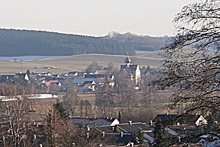
Thannhausen is a town in the district of Günzburg, in Bavaria, Germany. It is situated on the river Mindel, 24 kilometres (15 mi) southeast of Günzburg, and 33 kilometres (21 mi) west of Augsburg.

Ursberg Abbey is a former Premonstratensian monastery, now a convent of the Franciscan St. Joseph's Congregation, situated in the small village of Ursberg in the district of Günzburg, Bavaria.

<span class="mw-page-title-main">Ursberg</span> Municipality in Bavaria, Germany

Ursberg is a municipality in the district of Günzburg in Bavaria in Germany.

<span class="mw-page-title-main">Neuburg am Inn</span> Municipality in Bavaria, Germany

Neuburg am Inn is a municipality in the district of Passau in Bavaria in Germany.

<span class="mw-page-title-main">Niederraunau</span>

Niederraunau is a quarter of the town Krumbach in Günzburg (district), Swabia, Bavaria, Germany.

<span class="mw-page-title-main">Iller-Lech Plateau</span>

The Iller-Lech Plateau, also known as the Upper Swabian Plateau, is one of the natural regions of Germany.

<span class="mw-page-title-main">Kammel</span> River in Germany

The Kammel is a river in Bavaria, southern Germany. The Kammel originates west of Mindelheim, in the district Unterallgäu, and flows generally north. It flows into the Mindel south of Offingen at the Danube, east of Günzburg in the district Günzburg. So it is an indirect right tributary of the Danube. The difference in altitude between the origin and the mouth is 265 m.

<span class="mw-page-title-main">Bundesstraße 16</span>

The Bundesstraße 16 or B 16 is one of the German federal highways crossing southern Bavaria from east to south. It runs from the Bavarian Forest to Regensburg and then along the river Danube to Günzburg. From Roding to Regensburg the highway is developed without any junctions and is in parts signed as B 16n. From Günzburg to Füssen the B 16 runs from north to south.

Hürben, today the eastern part of Krumbach in Bavarian Swabia, was an independent village before it was incorporated into the neighbouring town of Krumbach in the year 1902. The Kammel was in most parts the border between Krumbach and Hürben.

<span class="mw-page-title-main">Krumbach (Kammel)</span> River in Germany

Krumbach is a river of Bavaria, Germany. It is a left tributary of the Kammel in the town Krumbach.

<span class="mw-page-title-main">Edelstetten Abbey</span> Former convent in the Roman Catholic Diocese of Augsburg, Germany

The Monastery Edelstetten is a former Kanonissenstift convent located at 48°17′N 10°22′E in the city of Edelstetten, a municipality of Neuburg an der Kammel in Bavaria, Germany. The monastery is in the diocese of Augsburg and in the valley of the Haselbach River.

<span class="mw-page-title-main">Neu-Ulm (electoral district)</span> Federal electoral district of Germany

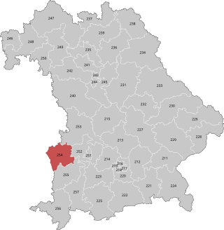
Neu-Ulm is an electoral constituency represented in the Bundestag. It elects one member via first-past-the-post voting. Under the current constituency numbering system, it is designated as constituency 255. It is located in southwestern Bavaria, comprising the Günzburg district, Neu-Ulm district, and the northwestern part of the Unterallgäu district.

References

    Coordinates: 48°14′35″N10°21′48″E / 48.2431°N 10.3633°E / 48.2431; 10.3633