Banya is a town in Southern Bulgaria. It is in Karlovo Municipality, Plovdiv Province and is close to Karlovo.

Boboshevo is a town in Western Bulgaria. It is located in Kyustendil Province and is close to the towns of Kocherinovo and Rila.

Barakovo is a village in Kocherinovo Municipality, Kyustendil Province of southwest Bulgaria. As of 2013, it had a population of 468. It is situated at the western foothills of the Rila Mountains on the banks of the Rilska River. Between 1974 and 1991 it was administratively a neighbourhood of the town of Kocherinovo.

Krumovo is a village in the Plovdiv Province, southern Bulgaria. As of 2006 it has 3,378 inhabitants. The village is located at 2 km to the south of the Maritsa river and at 12 km to the south-east of Plovdiv. The Plovdiv International Airport is located in the vicinity of the village. It is also famous for its grapes sort Krumovski mavrud. Every 2 years the BIAF Airshow is held on the Krumovo Airbase, resulting in heavy parking problems in the village.
Rodopi municipality is situated in the Plovdiv Province, southern Bulgaria. As of 2006 the population is 33,111.
Krumovo Gradishte is a village in Karnobat Municipality, in Burgas Province, in southeastern Bulgaria.
Krumovo is a village in Aksakovo Municipality, in Varna Province, Bulgaria.

Stob is a village in southwest Bulgaria, administratively part of Kocherinovo Municipality, Kyustendil Province. Located at the foot of the Rila mountains and not far from the Rila Monastery, Stob was first mentioned in the 7th century and has been in continuous or near-continuous existence since then. Stob is notable for the Stob Earth Pyramids, a natural rock phenomenon in the vicinity of the village.

Buranovo is a village in Kocherinovo Municipality, Kyustendil Province, south-western Bulgaria. As of 2013 it has 152 inhabitants. It is situated close to the right bank of the Struma River just south of the village of Borovets, at some 2 km to the north-west of the municipal centre Kocherinovo.

Dragodan is a village in Kocherinovo Municipality, Kyustendil Province, south-western Bulgaria. As of 2013 it has 94 inhabitants. It is situated close to the right bank of the Struma River to the north of the village of Borovets, at some 2 km to the north-west of the municipal centre Kocherinovo.
Frolosh is a village in Kocherinovo Municipality, Kyustendil Province, south-western Bulgaria. As of 2013 it has 120 inhabitants. It is situated in the picturesque northern section of the Vlahina mountain range with views to Bulgaria's highest mountain range Rila and the village of Mursalevo to the west.
Mursalevo is a village in Kocherinovo Municipality, Kyustendil Province, south-western Bulgaria. As of 2013 it has 413 inhabitants. It is situated on the left bank of the Struma River at about 2 km north of the municipal centre Kocherinovo.

Porominovo is a village in Kocherinovo Municipality, Kyustendil Province, south-western Bulgaria. As of 2013 it has 453 inhabitants. It is situated at the western foothills of the Rila Mountains on the banks of the Rilska River in the vicinity of the Stob Earth Pyramids.
Tsarvishte is a village in Kocherinovo Municipality, Kyustendil Province, south-western Bulgaria. As of 2013 it has 64 inhabitants. It is situated in the northern section of the Vlahina mountain range close to the town of Boboshevo to the north-west.

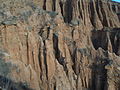
The Stob Earth Pyramids are rock formations, known as hoodoos, situated at the foothills of the Rila mountain range in south-western Bulgaria. They span an area of 0.7 km2 near the village of Stob, Kyustendil Province. The rock formations are up to 12 m high and up to 40 m thick at the base. Their shape is mostly conical to mushroomlike. Some of the columns are topped by flat stones.

The Rilska River is a river in south-western Bulgaria, a left tributary of the Struma. The river is 51 km long and drains the western sections of the Rila mountain range.