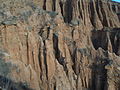
Sredna Gora is a mountain range in central Bulgaria, situated south of and parallel to the Balkan mountain range and extending from the Iskar River to the west and the elbow of Tundzha north of Yambol to the east. Sredna Gora is 285 km long, reaching 50 km at its greatest width. Its highest peak is Golyam Bogdan at 1,604 m (5,262 ft).
Bahalin is a small village in Slivnitsa Municipality, Sofia Province, located in western Bulgaria approximately 15 km west of the town of Slivnitsa.

Gobiaty is a village in the administrative district of Gmina Gródek, within Białystok County, Podlaskie Voivodeship, in north-eastern Poland, close to the border with Belarus. It lies approximately 16 kilometres (10 mi) east of Gródek and 48 km (30 mi) east of the regional capital Białystok.
Tarnowo is a village in the administrative district of Gmina Miastkowo, within Łomża County, Podlaskie Voivodeship, in north-eastern Poland. It lies approximately 8 kilometres (5 mi) south-east of Miastkowo, 15 km (9 mi) south-west of Łomża, and 86 km (53 mi) west of the regional capital Białystok.
Kamionka is a village in the administrative district of Gmina Opole Lubelskie, within Opole Lubelskie County, Lublin Voivodeship, in eastern Poland. It lies approximately 7 kilometres (4 mi) south-west of Opole Lubelskie and 51 km (32 mi) west of the regional capital Lublin.
Młodziejów is a village in the administrative district of Gmina Piaski, within Świdnik County, Lublin Voivodeship, in eastern Poland. It lies approximately 4 kilometres (2 mi) south-east of Piaski, 17 km (11 mi) south-east of Świdnik, and 27 km (17 mi) south-east of the regional capital Lublin.
Jankowo is a village in the administrative district of Gmina Czerwonka, within Maków County, Masovian Voivodeship, in east-central Poland. It lies approximately 7 kilometres (4 mi) west of Czerwonka, 3 km (2 mi) north-east of Maków Mazowiecki, and 75 km (47 mi) north of Warsaw.
Proszów is a village in the administrative district of Gmina Rychtal, within Kępno County, Greater Poland Voivodeship, in west-central Poland. It lies approximately 5 kilometres (3 mi) south-east of Rychtal, 20 km (12 mi) south of Kępno, and 158 km (98 mi) south-east of the regional capital Poznań.

Frolosh Point is the point forming the north side of the entrance to Galata Cove on the northeast coast of Anvers Island in the Palmer Archipelago, Antarctica.
Krushovo is a village in Karnobat Municipality, in Burgas Province, in southeastern Bulgaria.
Bizhovtsi is a village in Tryavna Municipality, in Gabrovo Province, in northern central Bulgaria.
Koevtsi is a village in Tryavna Municipality, in Gabrovo Province, in northern central Bulgaria.
Lambuh is a village in the municipality of Ivaylovgrad, in Haskovo Province, in southern Bulgaria.
Gralska Padina is a village in Dragoman Municipality, Sofia Province, western Bulgaria.
Kambelevtsi is a village in Dragoman Municipality, Sofia Province, western Bulgaria.
Batulia is a village in Svoge Municipality, Sofia Province, western Bulgaria.
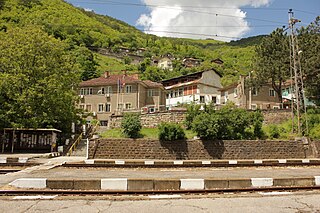
Rebrovo is a village in Svoge Municipality, Sofia Province, western Bulgaria.
Tseretsel is a village in Svoge Municipality, Sofia Province, western Bulgaria.
Skandaloto is a village in Apriltsi Municipality, Lovech Province, northern Bulgaria.
Velchevo is a village in Apriltsi Municipality, Lovech Province, northern Bulgaria.