The Iskar is a right tributary of the Danube. With a length of 368 km it is the longest river that runs entirely within Bulgaria. Originating as three forks in Balkan's highest mountain range Rila, it flows in northern direction until its confluence with the Danube River. As it flows northwards it fuels the largest artificial lake in the country, the Iskar Reservoir, forms the divide between the Vitosha and Plana Mountains in the west and the Sredna Gora mountain range in the east before entering the Sofia Valley, which contains the nation's capital Sofia. From there the Iskar runs through the Balkan Mountains forming the spectacular 84 km long Iskar Gorge and as it crosses the mountains its water course turns in north-eastern direction at Lakatnik. North of the Balkan Mountains the river crosses the Danubian Plain and finally flows into the Danube between the villages of Baykal and Gigen. Geologically, Iskar is the oldest river in the Balkan Peninsula.

The Popovo Lake is a glacial lake situated in the northern section of the Pirin mountain range, south-western Bulgaria. It is one of the eleven Popovi Lakes. The lake and its surroundings are among the most popular places for summer tourism in Pirin National Park. It is situated at the bottom of the Popovski cirque and is surrounded by the peaks Sivria (2,591 m), Dzhano (2,668 m), Kralev Dvor (2,680 m), Momin Dvor (2,723 m) and Dzhengal (2,730 m).

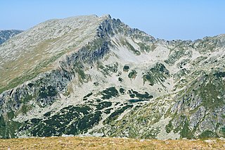
Kutelo is a summit in the Pirin mountain range, southwestern Bulgaria. With a height of 2,908 m it is the second highest peak in Pirin after Vihren (2,914 m), and the third one in Bulgaria, behind Musala (2,925 m) in Rila and Vihren. Kutelo is a double peak with a small saddle between the two parts, the lower being only one meter below the higher one, at 2,907 m. Seen from the town of Bansko it appears higher than Vihren.

Barakovo is a village in Kocherinovo Municipality, Kyustendil Province of southwest Bulgaria. As of 2013, it had a population of 468. It is situated at the western foothills of the Rila Mountains on the banks of the Rilska River. Between 1974 and 1991 it was administratively a neighbourhood of the town of Kocherinovo.

Veselie is a village in Primorsko Municipality, Burgas Province, in southeastern Bulgaria. As of 2013 it has 539 inhabitants.

Atia or Atiya is a village in Sozopol Municipality, Burgas Province, south-eastern Bulgaria. As of 2013 it has 825 inhabitants. It hosts Bulgaria's largest naval base.
Ravadinovo is a village in Sozopol Municipality, in Burgas Province, in southeastern Bulgaria. As of 2013 it has 691 inhabitants.

Rosen is a village in Sozopol Municipality, in Burgas Province, in south-eastern Bulgaria. As of 2013 it has 1470 inhabitants.
Paril is a mountain saddle (pass) in western Bulgaria between the mountain ranges of Pirin to the north and Slavyanka to the south. It is situated on the territory of the Sandanski and Hadzhidimovo municipalities in Blagoevgrad Province.

Bayuvi Dupki–Dzhindzhiritsa, also spelled Doupki–Djindjiritza, is a nature reserve in Pirin National Park, located in the homonymous mountain range in south-western Bulgaria. It is situated in Razlog Municipality, Blagoevgrad Province. Bayuvi Dupki–Dzhindzhiritsa is among the nation's oldest reserves, declared in 1934 to protect the forests of Macedonian pine and Bosnian pine, both Balkan endemic species. Its territory was further expanded in 1976 and 1980 and spans an area of 2873 ha or 28,73 km2. It was declared a UNESCO Biosphere Reserve in 1977. The reserve encompasses territory between 1200 and 2907 m altitude. Geologically it is dominated by Proterozoic marbles and has extensive karst terrain with numerous caves and karst formations.
Tisata is a nature reserve in south-western Bulgaria. It is situated in Kresna Municipality, Blagoevgrad Province. The reserve is managed by the administration of Pirin National Park despite the fact it lies outside the limits of the park.

Kamenitsa is a peak in the Pirin mountain range, south-western Bulgaria. It is located in the northern part of Pirin on the 22 km-long Kamenitsa secondary ridge between the summits of Malka Kamenitsa to the north and Yalovarnika (2,763 m) to the south. Its height is 2,822 m which ranks it on fifth place in Pirin, behind Vihren (2,914 m), Kutelo (2,908 m), Banski Suhodol (2,884 m) and Polezhan (2,851 m). The peak is built up of granite blocks covered in lichens.
The Sandanska Bistritsa is a river in south-western Bulgaria, a left tributary of the Struma. The river is 33 km long and drains the south-western sections of the Pirin mountain range.

Orelyak, also known as Orelek or Orlovi skali, is a peak in the Pirin mountain range, south-western Bulgaria. Reaching height of 2,099 m, it is the highest summit of Central Pirin, the second-highest subdivision of the mountain range. Orelayk is situated on Pirin's main ridge to the north of the Baba Peak and to the north-west of the Chala Peak. It has the shape of a triangular dome. The western slopes descend steeply, at places vertically, to the valley of the Pirinska Bistritsa river. Orelayk is built up of karstificated marbles. Near its highest point is located a 96 m-high radio and television repeater. The lower part of the northern slopes falls within the territory of the Orelyak Reserve, created to protect the old growth beech forests of Central Pirin.
Yalovarnika is a 2,763 m-high peak in the Pirin mountain range, south-western Bulgaria. It is located in the northern part of Pirin on the 22 km-long Kamenitsa secondary ridge between the summits of Kamenitsa (2,822 m) to the north and Zabat (2,688 m), Kuklite (2,686 m) and Golena (2,633 m) to the south.

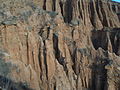
The Melnik Earth Pyramids are rock formations, known as hoodoos, situated at the foothills of the Pirin mountain range in south-western Bulgaria. They span an area of 17 km2 near the town of Melnik, Blagoevgrad Province. Reaching a height of up to 100 m these sandstone pyramids are shaped in forms, resembling giant mushrooms, ancient towers and obelisks. They were formed primarily due to erosion from rainfall and bedrock wear. The Melnik Earth Pyramids are a geological phenomenon of global importance and were declared a natural landmark in 1960. The rock formations are home to rich flora and fauna heavily influenced by the Mediterranean climate. They are a tourist destination due to the natural environment of the area, the cultural sights of Melnik and the Rozhen Monastery.

The Rilska River is a river in south-western Bulgaria, a left tributary of the Struma. The river is 51 km long and drains the western sections of the Rila mountain range.

Momin Dvor is a 2,723 m high peak in the Pirin mountain range, south-western Bulgaria. It is located in the northern part of Pirin on its main ridge between the summits of Kralev Dvor (2,680 m) and Dzhengal (2,730 m). Momin Dvor is pyramid-shaped and was formed by glacial erosion from the three neighbouring cirques: Valyavishki, Popovski and Belemeto. It is built up of porphyry granite.

Buzludzha is a historical peak in the Central Balkan Mountains, Bulgaria. The mountain is located to the east of the Shipka Pass near the town of Kazanlak and is a site of historical importance. The peak is 1,441 metres high. It was renamed to Hadzhi Dimitar in 1942 but remains popularly known as Buzludzha. The summit is built up of limestone and granite. Its slopes are covered with grassy vegetation; its foothills and the neighbouring peaks sustain beech forests.

Medni Rid, also known as Bakarlak (Бакърлък) until 1942, is a ridge in south-eastern Bulgaria. It forms the north-eastern extreme of the Bosna Ridge in the Strandzha Mountains. Administratively, it lies in the municipalities of Sozopol and Primorsko, Burgas Province.