
Ludwin is a village in Łęczna County, Lublin Voivodeship, in eastern Poland. It is the seat of the gmina called Gmina Ludwin. It lies approximately 4 kilometres (2 mi) north of Łęczna and 25 km (16 mi) east of the regional capital Lublin.
Łęczna Lake District Landscape Park or Łęczna Lakeland Scenic Park is a protected area in eastern Poland, established in 1990, covering an area of 118.16 square kilometres (45.62 sq mi) in the geographic region called the Łęczna-Włodawa Lakeland or the Łęczna-Włodawa Plain.
Giżyce is a village in the administrative district of Gmina Michów, within Lubartów County, Lublin Voivodeship, in eastern Poland. It lies approximately 10 kilometres (6 mi) north-east of Michów, 22 km (14 mi) north-west of Lubartów, and 42 km (26 mi) north of the regional capital Lublin.
Gołąb is a village in the administrative district of Gmina Michów, within Lubartów County, Lublin Voivodeship, in eastern Poland. It lies approximately 6 kilometres (4 mi) south-east of Michów, 16 km (10 mi) west of Lubartów, and 31 km (19 mi) north-west of the regional capital Lublin.
Młyniska is a village in the administrative district of Gmina Michów, within Lubartów County, Lublin Voivodeship, in eastern Poland. It lies approximately 6 kilometres (4 mi) north-east of Michów, 18 km (11 mi) north-west of Lubartów, and 36 km (22 mi) north of the regional capital Lublin.
Borków is a village in the administrative district of Gmina Garbów, within Lublin County, Lublin Voivodeship, in eastern Poland. It lies approximately 6 kilometres (4 mi) north-east of Garbów and 20 km (12 mi) north-west of the regional capital Lublin.
Garbatówka is a village in the administrative district of Gmina Cyców, within Łęczna County, Lublin Voivodeship, in eastern Poland. It lies approximately 8 kilometres (5 mi) north of Cyców, 18 km (11 mi) north-east of Łęczna, and 41 km (25 mi) east of the regional capital Lublin.
Zagórze is a village in the administrative district of Gmina Cyców, within Łęczna County, Lublin Voivodeship, in eastern Poland. It lies approximately 9 kilometres (6 mi) north-east of Cyców, 24 km (15 mi) east of Łęczna, and 46 km (29 mi) east of the regional capital Lublin.
Dratów is a village in the administrative district of Gmina Ludwin, within Łęczna County, Lublin Voivodeship, in eastern Poland. It lies approximately 4 kilometres (2 mi) north-east of Ludwin, 8 km (5 mi) north-east of Łęczna, and 29 km (18 mi) north-east of the regional capital Lublin.
Kaniwola is a village in the administrative district of Gmina Ludwin, within Łęczna County, Lublin Voivodeship, in eastern Poland. It lies approximately 10 kilometres (6 mi) east of Ludwin, 13 km (8 mi) north-east of Łęczna, and 35 km (22 mi) east of the regional capital Lublin.
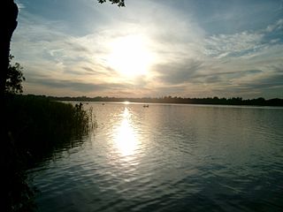
Kobyłki is a village in the administrative district of Gmina Ludwin, within Łęczna County, Lublin Voivodeship, in eastern Poland. It lies approximately 8 kilometres (5 mi) north-east of Ludwin, 11 km (7 mi) north-east of Łęczna, and 33 km (21 mi) north-east of the regional capital Lublin. Name of Kobyłki, the most closely can be translated as "Mares". In mid 90's the area south of Kobyłki had enjoyed minor mining damage, the cause was quite close neighborhood of Bogdanka Coal Mine and its large-scale operations, and as the result the least urbanized parts of the village are planned to be sunk, seamlessly expanding an artificial lake. The area is rich in open landscapes, natural resources, including number of fish, and rare species of birds living on Pojezierze Łęczyńskie. The area has been focused on sustainable development, observing a slight decrease in the reliance on agriculture, in favor of agrotourism serving residents of near-by Łęczna, and Lublin area. The community hosts number of farmers who grow apples, strawberries, pears, currants, raspberries, gooseberries, tobacco, corn, beer hops and various other crops.
Kocia Góra is a village in the administrative district of Gmina Ludwin, within Łęczna County, Lublin Voivodeship, in eastern Poland. It lies approximately 7 kilometres (4 mi) north-west of Ludwin, 10 km (6 mi) north of Łęczna, and 26 km (16 mi) north-east of the regional capital Lublin.
Ludwin-Kolonia is a village in the administrative district of Gmina Ludwin, within Łęczna County, Lublin Voivodeship, in eastern Poland.
Rogóźno is a village in the administrative district of Gmina Ludwin, within Łęczna County, Lublin Voivodeship, in eastern Poland. It lies approximately 8 kilometres (5 mi) north-east of Ludwin, 12 km (7 mi) north-east of Łęczna, and 32 km (20 mi) north-east of the regional capital Lublin.
Uciekajka is a village in the administrative district of Gmina Ludwin, within Łęczna County, Lublin Voivodeship, in eastern Poland. It lies approximately 7 kilometres (4 mi) north-east of Ludwin, 11 km (7 mi) north-east of Łęczna, and 32 km (20 mi) north-east of the regional capital Lublin.
Klarów is a village in the administrative district of Gmina Milejów, within Łęczna County, Lublin Voivodeship, in eastern Poland. It lies approximately 2 kilometres (1 mi) north-east of Milejów-Osada, 9 km (6 mi) south-east of Łęczna, and 27 km (17 mi) east of the regional capital Lublin.
Januszówka is a village in the administrative district of Gmina Spiczyn, within Łęczna County, Lublin Voivodeship, in eastern Poland. It lies approximately 3 kilometres (2 mi) east of Spiczyn, 9 km (6 mi) north-west of Łęczna, and 20 km (12 mi) north-east of the regional capital Lublin.
Kamionka is a village in the administrative district of Gmina Stoczek Łukowski, within Łuków County, Lublin Voivodeship, in eastern Poland. It lies approximately 7 kilometres (4 mi) south of Stoczek Łukowski, 27 km (17 mi) west of Łuków, and 85 km (53 mi) north-west of the regional capital Lublin.
Trzcianki is a village in the administrative district of Gmina Janowiec, within Puławy County, Lublin Voivodeship, in eastern Poland. It lies approximately 7 kilometres (4 mi) north of Janowiec, 6 km (4 mi) south-west of Puławy, and 48 km (30 mi) west of the regional capital Lublin.


