Krzczonowice, Staszów County

Last updated
Krzczonowice
Village
Poland adm location map.svg
Red pog.svg
Krzczonowice
Coordinates: 50°30′39″N21°05′59″E / 50.51083°N 21.09972°E / 50.51083; 21.09972
Country Flag of Poland.svg  Poland
Voivodeship Świętokrzyskie
County Staszów
Gmina Staszów
Sołectwo Krzczonowice
Elevation 193.4 m (634.5 ft)
Population (31 December 2009 at Census) [1]
  TotalDecrease2.svg 268
Time zone CET (UTC+1)
  Summer (DST) CEST (UTC+2)
Postal code28-200
Area code(s) +48 15
Car plates TSZ

Krzczonowice [2] [3] [kʂt͡ʂɔnɔˈvit͡sɛ] is a village in the administrative district of Gmina Staszów, within Staszów County, Świętokrzyskie Voivodeship, in south-central Poland. It lies approximately 8 kilometres (5 mi) south-west of Staszów and 54 km (34 mi) south-east of the regional capital Kielce. [4]

Village Small clustered human settlement smaller than a town

A village is a clustered human settlement or community, larger than a hamlet but smaller than a town, with a population ranging from a few hundred to a few thousand. Though villages are often located in rural areas, the term urban village is also applied to certain urban neighborhoods. Villages are normally permanent, with fixed dwellings; however, transient villages can occur. Further, the dwellings of a village are fairly close to one another, not scattered broadly over the landscape, as a dispersed settlement.

Gmina Staszów Gmina in Świętokrzyskie, Poland

Gmina Staszów is an urban-rural gmina in Staszów County, Świętokrzyskie Voivodeship, in south-central Poland. Its seat is the town of Staszów, which lies approximately 53 kilometres (33 mi) south-east of the regional capital Kielce.

Staszów County County in Świętokrzyskie, Poland

Staszów County is a unit of territorial administration and local government (powiat) in Świętokrzyskie Voivodeship, south-central Poland. It came into being on January 1, 1999, as a result of the Polish local government reforms passed in 1998. Its administrative seat and largest town is Staszów, which lies 53 kilometres (33 mi) south-east of the regional capital Kielce. The county also contains the towns of Połaniec, lying 17 km (11 mi) south-east of Staszów, and Osiek, 21 km (13 mi) east of Staszów.

The village has a population of Decrease2.svg 268.

Demography

According to the 2002 Poland census, there were 282 people residing in Krzczonowice village, of whom 51.1% were male and 48.9% were female. In the village, the population was spread out with 26.2% under the age of 18, 33.3% from 18 to 44, 20.9% from 45 to 64, and 19.5% who were 65 years of age or older. [1]

Polish census of 2002 was a census in Poland taken from 21 May to 8 June 2002.

Table 1. Population level of village in 2002 — by age group [1]
SPECIFICATIONMeasure
unit
POPULATION
(by age group in 2002)
TOTAL 0-9 10-19 20-29 30-39 40-49 50-59 60-69 70-79 80 +
I. TOTAL person 282 44 43 31 32 36 36 25 26 9
of which in % 100 15.6 15.2 11 11.3 12.8 12.8 8.9 9.2 3.2
1. BY SEX
A. Males person 144 25 24 12 18 19 17 12 14 3
of which in % 51.1 8.9 8.5 4.3 6.4 6.7 6 4.3 5 1.1
B. Females person 138 19 19 19 14 17 19 13 12 6
of which in % 48.9 6.7 6.7 6.7 5 6 6.7 4.6 4.3 2.1
Krzczonowice%2C Stasz%C3%B3w County


Figure 1. Population pyramid of village in 2002 — by age group and sex [1]
Table 2. Population level of village in 2002 — by sex [1]
SPECIFICATIONMeasure
unit
POPULATION
(by sex in 2002)
TOTAL Males Females
I. TOTAL person 282 144 138
of which in % 100 51.1 48.9
1. BY AGE GROUP
A. At pre-working age person 74 41 33
of which in % 26.2 14.5 11.7
B. At working age. grand total person 153 79 74
of which in % 54.3 28.1 26.2
a. at mobile working age person 94 45 49
of which in                         % 33.3 16 17.3
b. at non-mobile working age person 59 34 25
of which in                         % 20.9 12 8.9
C. At post-working age person 55 24 31
of which in % 19.5 8.5 11

Related Research Articles

Czernica, Świętokrzyskie Voivodeship Village in Świętokrzyskie, Poland

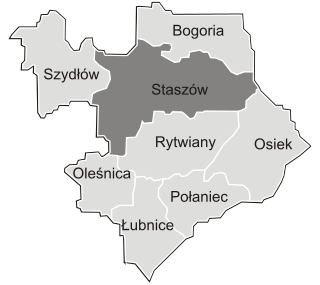
Czernica is a village in the administrative district of Gmina Staszów, within Staszów County, Świętokrzyskie Voivodeship, in south-central Poland. It lies approximately 6 kilometres (4 mi) north of Staszów and 48 km (30 mi) south-east of the regional capital Kielce.

Łaziska, Staszów County Village in Świętokrzyskie, Poland

Łaziska is a village in the administrative district of Gmina Staszów, within Staszów County, Świętokrzyskie Voivodeship, in south-central Poland. It lies approximately 10 kilometres (6 mi) north-east of Staszów and 55 km (34 mi) south-east of the regional capital Kielce.

Niemścice Village in Świętokrzyskie, Poland

Niemścice is a village in the administrative district of Gmina Staszów, within Staszów County, Świętokrzyskie Voivodeship, in south-central Poland. It lies approximately 5 kilometres (3 mi) west of Staszów and 49 km (30 mi) south-east of the regional capital Kielce.

Oględów Village in Świętokrzyskie, Poland

Oględów is a village in the administrative district of Gmina Staszów, within Staszów County, Świętokrzyskie Voivodeship, in south-central Poland. It lies approximately 4 kilometres (2 mi) west of Staszów and 51 km (32 mi) south-east of the regional capital Kielce.

Stefanówek Village in Świętokrzyskie, Poland

Stefanówek is a village in the administrative district of Gmina Staszów, within Staszów County, Świętokrzyskie Voivodeship, in south-central Poland. It lies approximately 4 kilometres (2 mi) south-west of Staszów and 54 km (34 mi) south-east of the regional capital Kielce.

Wiśniowa Poduchowna Village in Świętokrzyskie, Poland

Wiśniowa Poduchowna is a village in the administrative district of Gmina Staszów, within Staszów County, Świętokrzyskie Voivodeship, in south-central Poland. It lies approximately 7 kilometres (4 mi) north-east of Staszów and 54 km (34 mi) south-east of the regional capital Kielce.

Zagrody, Staszów County Village in Świętokrzyskie, Poland

Zagrody is a village in the administrative district of Gmina Staszów, within Staszów County, Świętokrzyskie Voivodeship, in south-central Poland. It lies approximately 5 kilometres (3 mi) north-west of Staszów and 48 km (30 mi) south-east of the regional capital Kielce.

Ziemblice Village in Świętokrzyskie, Poland

Ziemblice is a village in the administrative district of Gmina Staszów, within Staszów County, Świętokrzyskie Voivodeship, in south-central Poland. It lies approximately 5 kilometres (3 mi) west of Staszów and 51 km (32 mi) south-east of the regional capital Kielce.

Domaradzice, Świętokrzyskie Voivodeship Village in Świętokrzyskie, Poland

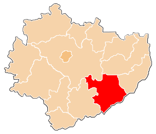
Domaradzice is a village in the administrative district of Gmina Bogoria, within Staszów County, Świętokrzyskie Voivodeship, in south-central Poland. It lies approximately 7 kilometres (4 mi) east of Bogoria, 18 km (11 mi) north-east of Staszów, and 57 km (35 mi) south-east of the regional capital Kielce.

Podlesie, Gmina Bogoria Village in Świętokrzyskie, Poland

Podlesie is a village in the administrative district of Gmina Bogoria, within Staszów County, Świętokrzyskie Voivodeship, in south-central Poland. It lies approximately 3 kilometres (2 mi) south-east of Bogoria, 13 km (8 mi) north-east of Staszów, and 55 km (34 mi) south-east of the regional capital Kielce.

Wagnerówka Village in Świętokrzyskie, Poland

Wagnerówka is a village in the administrative district of Gmina Bogoria, within Staszów County, Świętokrzyskie Voivodeship, in south-central Poland. It lies approximately 5 kilometres (3 mi) south-east of Bogoria, 14 km (9 mi) north-east of Staszów, and 57 km (35 mi) south-east of the regional capital Kielce.

Witowice, Świętokrzyskie Voivodeship Village in Świętokrzyskie, Poland

Witowice is a village in the administrative district of Gmina Bogoria, within Staszów County, Świętokrzyskie Voivodeship, in south-central Poland. It lies approximately 7 kilometres (4 mi) east of Bogoria, 17 km (11 mi) north-east of Staszów, and 59 km (37 mi) south-east of the regional capital Kielce.

Wola Kiełczyńska Village in Świętokrzyskie, Poland

Wola Kiełczyńska is a village in the administrative district of Gmina Bogoria, within Staszów County, Świętokrzyskie Voivodeship, in south-central Poland. It lies approximately 3 kilometres (2 mi) north-west of Bogoria, 13 km (8 mi) north-east of Staszów, and 50 km (31 mi) south-east of the regional capital Kielce.

Wola Malkowska Village in Świętokrzyskie, Poland

Wola Malkowska is a village in the administrative district of Gmina Bogoria, within Staszów County, Świętokrzyskie Voivodeship, in south-central Poland. It lies approximately 5 kilometres (3 mi) west of Bogoria, 12 km (7 mi) north of Staszów, and 48 km (30 mi) south-east of the regional capital Kielce.

Wysoki Duże Village in Świętokrzyskie, Poland

Wysoki Duże is a village in the administrative district of Gmina Bogoria, within Staszów County, Świętokrzyskie Voivodeship, in south-central Poland. It lies approximately 3 kilometres (2 mi) north-east of Bogoria, 15 km (9 mi) north-east of Staszów, and 54 km (34 mi) south-east of the regional capital Kielce.

Wysoki Średnie Village in Świętokrzyskie, Poland

Wysoki Średnie is a village in the administrative district of Gmina Bogoria, within Staszów County, Świętokrzyskie Voivodeship, in south-central Poland. It lies approximately 4 kilometres (2 mi) east of Bogoria, 15 km (9 mi) north-east of Staszów, and 55 km (34 mi) south-east of the regional capital Kielce.

Zimnowoda, Świętokrzyskie Voivodeship Village in Świętokrzyskie, Poland

Zimnowoda is a village in the administrative district of Gmina Bogoria, within Staszów County, Świętokrzyskie Voivodeship, in south-central Poland. It lies approximately 3 kilometres (2 mi) southwest of Bogoria, 10 km (6 mi) northeast of Staszów, and 52 km (32 mi) south-east of the regional capital Kielce.

Zalesie, Staszów County Village in Świętokrzyskie, Poland

Zalesie is a village in the administrative district of Gmina Łubnice, within Staszów County, Świętokrzyskie Voivodeship, in south-central Poland. It lies approximately 6 kilometres (4 mi) south of Łubnice, 22 km (14 mi) south of Staszów, and 69 km (43 mi) south-east of the regional capital Kielce.

Kraśnik, Świętokrzyskie Voivodeship Village in Świętokrzyskie, Poland

Kraśnik is a village in the administrative district of Gmina Połaniec, within Staszów County, Świętokrzyskie Voivodeship, in south-central Poland. It lies approximately 3 kilometres (2 mi) south-west of Połaniec, 17 km (11 mi) south of Staszów, and 69 km (43 mi) south-east of the regional capital Kielce.

Maśnik Village in Świętokrzyskie, Poland

Maśnik is a village in the administrative district of Gmina Połaniec, within Staszów County, Świętokrzyskie Voivodeship, in south-central Poland. It lies approximately 6 kilometres (4 mi) south-west of Połaniec, 20 km (12 mi) south of Staszów, and 70 km (43 mi) south-east of the regional capital Kielce.

References

  1. 1 2 3 4 5 "Local Data Bank (Bank Danych Lokalnych) – Layout by NTS nomenclature (Układ wg klasyfikacji NTS)". demografia.stat.gov.pl: GUS. 10 March 2011.
  2. Bielec, Jan (ed.); Szwałek, Stanisława (1981). Wykaz urzędowych nazw miejscowości w Polsce. T. II: K – P[List of official names of localities in Poland, Vol. II: K – P] (in Polish). Ministry of Administration, Spatial Economy and Environmental Protection (1st ed.). Warsaw, Poland: Central Statistical Office.
  3. "Krzczonowice, wieś, gmina Staszów — obszar wiejski, powiat staszowski, województwo świętokrzyski" [Krzczonowice, village, Staszów Commune — rural area, Staszów County, Świętokrzyskie Province, Poland]. Topographical map prepared in 1:10,000 scale. Aerial and satellite orthophotomap (in Polish). Head Office of Geodesy and Cartography, Poland, Warsaw. 2011. geoportal.gov.pl. Retrieved 27 April 2011.
  4. "Central Statistical Office (GUS) - TERYT (National Register of Territorial Land Apportionment Journal)" (in Polish). 2008-06-01.


Coordinates: 50°30′40″N21°5′55″E / 50.51111°N 21.09861°E / 50.51111; 21.09861

Geographic coordinate system Coordinate system

A geographic coordinate system is a coordinate system that enables every location on Earth to be specified by a set of numbers, letters or symbols. The coordinates are often chosen such that one of the numbers represents a vertical position and two or three of the numbers represent a horizontal position; alternatively, a geographic position may be expressed in a combined three-dimensional Cartesian vector. A common choice of coordinates is latitude, longitude and elevation. To specify a location on a plane requires a map projection.