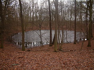
The Morasko meteorite nature reserve is located in Morasko, on the northern edge of the city of Poznań, Poland. It contains seven meteor craters. The reserve has an area of 55 hectares and was established in 1976.
Majówka is a village in the administrative district of Gmina Jemielno, within Góra County, Lower Silesian Voivodeship, in south-western Poland. Prior to 1945 it was in Germany.

Dąbie is a village in the administrative district of Gmina Wińsko, within Wołów County, Lower Silesian Voivodeship, in south-western Poland. Prior to 1945 it was in Germany.
Mrokocin is a village in the administrative district of Gmina Kamieniec Ząbkowicki, within Ząbkowice Śląskie County, Lower Silesian Voivodeship, in south-western Poland. Prior to 1945 it was in Germany.
Dąbrówka is a village in the administrative district of Gmina Kowal, within Włocławek County, Kuyavian-Pomeranian Voivodeship, in north-central Poland.
Dobryń-Kolonia is a village in the administrative district of Gmina Zalesie, within Biała Podlaska County, Lublin Voivodeship, in eastern Poland.
Wasilczyki-Gajówka is a village in the administrative district of Gmina Suwałki, within Suwałki County, Podlaskie Voivodeship, in north-eastern Poland.
Grauże Nowe is a village in the administrative district of Gmina Szypliszki, within Suwałki County, Podlaskie Voivodeship, in north-eastern Poland, close to the border with Lithuania.

Józefina is a village in the administrative district of Gmina Lututów, within Wieruszów County, Łódź Voivodeship, in central Poland. It lies approximately 5 kilometres (3 mi) north-east of Lututów, 26 km (16 mi) north-east of Wieruszów, and 81 km (50 mi) south-west of the regional capital Łódź.
Truszków is a village in the administrative district of Gmina Opole Lubelskie, within Opole Lubelskie County, Lublin Voivodeship, in eastern Poland.

Rytro is a village in Nowy Sącz County, Lesser Poland Voivodeship, in southern Poland. It is the seat of the gmina called Gmina Rytro. It lies approximately 16 kilometres (10 mi) south of Nowy Sącz and 83 km (52 mi) south-east of the regional capital Kraków.

Karwodrza is a village in the administrative district of Gmina Tuchów, within Tarnów County, Lesser Poland Voivodeship, in southern Poland. It lies approximately 3 kilometres (2 mi) north-east of Tuchów, 14 km (9 mi) south of Tarnów, and 83 km (52 mi) east of the regional capital Kraków.

Skórnice is a village in the administrative district of Gmina Fałków, within Końskie County, Świętokrzyskie Voivodeship, in south-central Poland. It lies approximately 3 kilometres (2 mi) west of Fałków, 26 km (16 mi) west of Końskie, and 48 km (30 mi) north-west of the regional capital Kielce.
Sobole is a village in the administrative district of Gmina Załuski, within Płońsk County, Masovian Voivodeship, in east-central Poland.

Kobylniki is a village in the administrative district of Gmina Kościan, within Kościan County, Greater Poland Voivodeship, in west-central Poland. It lies approximately 6 kilometres (4 mi) west of Kościan and 44 km (27 mi) south-west of the regional capital Poznań.
Bielów is a village in the administrative district of Gmina Krosno Odrzańskie, within Krosno Odrzańskie County, Lubusz Voivodeship, in western Poland.

Maszewo is a village in Krosno Odrzańskie County, Lubusz Voivodeship, in western Poland. It is the seat of the gmina called Gmina Maszewo. It lies approximately 14 kilometres (9 mi) west of Krosno Odrzańskie and 44 km (27 mi) west of Zielona Góra.

Kamionka is a settlement in the administrative district of Gmina Kartuzy, within Kartuzy County, Pomeranian Voivodeship, in northern Poland. It lies approximately 11 kilometres (7 mi) north-west of Kartuzy and 37 km (23 mi) west of the regional capital Gdańsk.

Chełm Gryficki is a village in the administrative district of Gmina Trzebiatów, within Gryfice County, West Pomeranian Voivodeship, in north-western Poland. It lies approximately 4 kilometres (2 mi) west of Trzebiatów, 18 km (11 mi) north of Gryfice, and 84 km (52 mi) north-east of the regional capital Szczecin.
Gazneh Kola is a village in Balatajan Rural District, in the Central District of Qaem Shahr County, Mazandaran Province, Iran. At the 2006 census, its population was 90, in 24 families.


