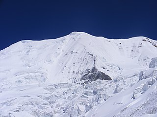
Mount Kuchela Dhura is a mountain located in Pithoragarh, Uttarakhand, India. It is located at the near true right bank of Lwa Glacier or true left bank of Shalang glacier, surrounded by Mount Nandakot, 6861 metres and 0.6041 metres to its south-west and north-east respectively. This peak offers a 3km (approx.) long rutted ridge leading to Nanda Kot’s north face.
An unknown attempt was made in the late 1980s, and no information of route and team. IMF sent an 8 members team to the peak via west ridge during pre-monsoon season in the year 2012. Team left behind from the summit by almost around 500 horizontal & 88 vertical metres.
The Indian Mountaineering Foundation (IMF) sent an expedition in the month of August–September 2013 to Mt Kuchela Dhura. The core Indian team had total 10 members from different states of the country Dhruv Joshi from Almora(leader), Wallambok Lyngdoh from Shillong (Dy. Leader), Dr Anand Vaidya from Gujarat (Medical Officer), Ram Prasad Lodha (Rajasthan), Zoram sanga(Mizoram), Vineet Saini(U.P), Vijay Rautela(Uttarakhand), Banshngainlang Nongkynrih(Meghalaya), Karan Kumar Shandilya (Assam) and Chitramohan Singh (Uttarakhand). Four members Dhruv joshi, Wallambok Lyngdoh, Chitramohan & Vijay Rautela successfully scaled the mountain on 6 September 2013 at 0820 hrs and made the first international and national ascent of the peak.
The expedition was flagged off by Col(Rtd) J P Bhagatjee on 15 August 2013, Director IMF and flagged in by Mick Fowler (Legendary Mountaineer and President of Alpine Club) on 20 September 2013. This expedition was sponsored by the Indian Mountaineering Foundation, Ministry of Youth Affairs & sports.
Nanda Devi is the second-highest mountain in India, after Kangchenjunga, and the highest located entirely within the country. Nanda Devi is the 23rd-highest peak in the world.
Kamet is the second-highest mountain in the Garhwal region of Uttarakhand, India, after Nanda Devi. It lies in the Chamoli District of Uttarakhand. Its appearance resembles a giant pyramid topped by a flat summit area with two peaks.
Oropolitics comes from the Greek oros meaning mountain and politikos meaning citizen. In modern usage it denotes the use of mountaineering for political purposes.
Pindari Kanda Traill's Pass is a mountain pass through the Himalayas located between Nanda Devi and Nanda Kot peaks in the Uttarakhand state in the districts of Pithoragarh and Bageshwar in India.
Nanda Kot is a mountain peak of the Himalaya range located in the Pithoragarh district of Uttarakhand state in India. It lies in the Kumaon Himalaya, just outside the ring of peaks enclosing the Nanda Devi Sanctuary, 15 kilometres (9 mi) southeast of Nanda Devi itself. The name Nanda Kot literally means "Nanda's Fortress" and refers to the abode of one of the sacred forms of the Hindu Goddess Parvati who in legend has made her sanctuary amongst the ring of lofty mountains in the region.
Chiring We is the Himalayan peak situated in eastern Kumaun of the Pithoragarh district of Uttarakhand state in India. The altitude of the peak is 6,559 m. Chiring We is the highest peak above the Kalabaland Glacier. Chiring We massif, which include peaks like Bamba Dhura (6,334 m), Suli Top (6,300 m), Trigal (5,983 m), Suitilla (6,373 m), separates Lassar Yankti valley from Kalabaland valley. The peak literally means 'Mountain of long life'. The route is through glaciers of Kalabaland, Sankalpa and Yankchar, icefall, crevasses, ice-pinnacles, ice walls and sharp ridges. First ascent to this peak was made in 1979 by an Indian team led by Harish Kapadia via northeast ridge.
Changuch is a Himalayan mountain peak situated at the boundary of Pithoragarh and Bageshwar district of the Uttarakhand state of India. This peak is situated above the Pindari Glacier. This peak offers a ridge leading to Nanda Kot. On its massif Traill's pass is situated, which connects Pindari valley to Goriganga valley. The first successful ascent to the peak was made by an Indo-British team on 9 June 2009 at 9 am.
The Nanda Devi National Park or Nanda Devi Biosphere Reserve, established in 1982 is a national park situated around the peak of Nanda Devi in Chamoli Garhwal district of Uttarakhand, in northern India. The entire park lies at an elevation of more than 3,500 m (11,500 ft) above mean sea level.
Nilkantha is a major peak of the Garhwal division of the Himalayas, in the Uttarakhand region of the Indian state of Uttarakhand. Although substantially lower than the highest peaks of the region, it towers dramatically over the valley of the Alaknanda River and rises 3,474 metres (11,398 ft) above the Hindu pilgrimage site of Badrinath, only 9 km (6 mi) to the east. Frank Smythe described the peak as "second only to Siniolchu in Himalayan beauty."
Mt. Nandakhat is positioned outside the Nandadevi sanctuary or at the rim of Nandadevi Sanctuary located in the Bageshwar district of Uttarakhand, India. at an elevation of 6,611 m.
Love Raj Singh Dharmshaktu is an Indian mountaineer who has climbed Mount Everest seven times.
Panwali Dwar is a mountain of the Kumaun Himalayas located in the Bageshwar district of Uttarakhand, India. The elevation of Panwali Dwar is 6,683 metres (21,926 ft) and its prominence is 763 metres (2,503 ft). It is 55th highest located entirely within the Uttarakhand. Nanda Devi, is the highest mountain in this category. It lies on southern wall of Nanda devi sanctuary. Its nearest higher neighbor Maiktoli 6,803 metres (22,320 ft) lies 8.2 km WSW. It is located 2.6 km SW of Nanda Khat 6,611 metres (21,690 ft) and 9.2 km NE lies Nanda Devi East 7,434 metres (24,390 ft).
Kalabaland Dhura is a mountain of the Garhwal Himalaya in Uttarakhand India. It situated at the head of Kalabaland Glacier. The elevation of Kalabaland Dhura is 6,105 metres (20,030 ft) and its prominence is 270 metres (886 ft). It is 158th highest located entirely within the Uttrakhand. Nanda Devi, is the highest mountain in this category. It lies 3 km south of Kalganga Dhura 6,215 metres (20,390 ft). Its nearest higher neighbor Bamba Dhura 6,334 metres (20,781 ft) lies 2.7 km ENE and it is 3.7 km west of Chiring We 6,559 metres (21,519 ft). It lies 6.9 km NW of Suli Top 6,300 metres (20,669 ft).
Sakram is a mountain of the Garhwal Himalaya in Uttarakhand India. It's situated on the eastern rim of Nanda Devi Sanctuary on the watershed of Milam Glacier and Nanda Devi basin. The elevation of Sakram is 6,254 metres (20,518 ft) and its prominence is 134 metres (440 ft). It is 129th highest located entirely within the Uttrakhand. Nanda Devi, is the highest mountain in this category. It lies 1.2 km SSW of Lohar Deo 6,267 metres (20,561 ft) its nearest higher neighbor and 3.3 km SSE of Deo Damla 6,620 metres (21,719 ft). Kalanka 6,931 metres (22,740 ft) lies 11.9 km NNW and 8.7 km SW lies Nanda Devi 7,816 metres (25,643 ft).
Bamchu is a mountain of the Garhwal Himalaya in Uttarakhand India. It's situated on the eastern rim of Nanda Devi Sanctuary on the watershed of Milam Glacier and Nanda Devi basin. The elevation of Bamchu is 6,303 metres (20,679 ft) and its prominence is 241 metres (791 ft). It is 124th highest located entirely within the Uttrakhand. Nanda Devi, is the highest mountain in this category. It lies 3.4 km South of Deo Damla 6,620 metres (21,719 ft) its nearest higher neighbor and 3.1 km SSE of Mangraon 6,568 metres (21,549 ft). Kalanka 6,931 metres (22,740 ft) lies 9.8 km NNW and 9.3 km SW lies Nanda Devi 7,816 metres (25,643 ft).
Deo Damla is a mountain of the Garhwal Himalaya in Uttarakhand, India. It is situated in the eastern rim of Nanda Devi Sanctuary on the watershed of Milam Glacier and Nanda Devi basin. The elevation of Deo Damla is 6,620 metres (21,719 ft) and its prominence is 693 metres (2,274 ft). It is 63rd highest located entirely within the Uttrakhand. Nanda Devi, is the highest mountain in this category. It lies 1.8 km SSE of Mangraon 6,568 metres (21,549 ft). Its nearest higher neighbor Rishi Pahar 6,992 metres (22,940 ft) lies 8.3 km NNW and it is 10.6 km SSW of Nanda Devi 7,816 metres (25,643 ft). It lies 1.4 km north of Bamchu 6,303 metres (20,679 ft).
Mangraon is a mountain of the Garhwal Himalaya in Uttarakhand India. It is situated in the eastern rim of Nanda Devi Sanctuary on the watershed of Milam Glacier and Nanda Devi basin. The elevation of Mangraon is 6,568 metres (21,549 ft) and its prominence is 563 metres (1,847 ft). It is joint 71st highest located entirely within the Uttrakhand. Nanda Devi, is the highest mountain in this category. It lies 1.8 km SSE of Deo Damla 6,568 metres (21,549 ft) its nearest higher neighbor. Rishi Pahar 6,992 metres (22,940 ft) lies 6.5 km North and it is 11.8 km NNE of Nanda Devi 7,816 metres (25,643 ft). It lies 9.5 km north of Lhatu Dhura 6,387 metres (20,955 ft).
Lhatu Dhura is a mountain of the Garhwal Himalaya in Uttarakhand, India. It is situated in the eastern rim of the Nanda Devi Sanctuary, on the watershed of the Milam Glacier and the Nanda Devi basin. The elevation of Lhatu Dhura is 6,392 metres (20,971 ft) and its prominence is 229 metres (751 ft). It is joint 103rd highest mountain located entirely within Uttrakhand. It lies 4.6 km south of Sakram 6,254 metres (20,518 ft). Its nearest higher neighbor Nanda Devi East lies 4.5 km to the south west, and Deo Damla lies 7.7 km to the north; it is 6.1 km east-north-east of Nanda Devi, and 9.5 km south of Mangraon.
Nanda Bhanar is a mountain of the Kumaun Himalaya in Uttarakhand India. The elevation of Nanda Bhanar is 6,236 metres (20,459 ft) and its prominence is 135 metres (443 ft). It is joint 134th highest located entirely within the Uttrakhand. Nanda Devi, is the highest mountain in this category. It lies 1.7 km SSW of Nanda Kot 6,861 metres (22,510 ft) its nearest higher neighbor. Dangthal 6,050 metres (19,849 ft) lies 5.5 km SSE and it is 15.2 km SSE of Nanda Devi 7,816 metres (25,643 ft). It lies 10.8 km north of Panwali Dwar 6,663 metres (21,860 ft).
Nandakhani is a mountain of the Kumaun Himalaya in Uttarakhand India. The elevation of Nandakhani is 6,029 metres (19,780 ft) and its prominence is 69 metres (226 ft). It is 169th highest located entirely within the Uttrakhand. Nanda Devi, is the highest mountain in this category. It lies .932 km SE of Nanda Bhanar 6,236 metres (20,459 ft) its nearest higher neighbor. Dangthal 6,050 metres (19,849 ft) lies 4.6 km SSE and it is 2.2 km SSE of Nanda Kot 6,861 metres (22,510 ft). It lies 19.2 km east of Maiktoli 6,803 metres (22,320 ft).
This page is based on this Wikipedia article Text is available under the CC BY-SA 4.0 license; additional terms may apply. Images, videos and audio are available under their respective licenses.