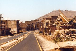
Quneitra is the largely destroyed and abandoned capital of the Quneitra Governorate in south-western Syria. It is situated in a high valley in the Golan Heights at 1,010 metres (3,313 feet) above sea level. Since 1974, pursuant to United Nations Security Council Resolution 350 and the Agreement on Disengagement between Israel and Syria, the city is inside the UN-patrolled buffer zone.

Quneitra Governorate is one of the fourteen governorates (provinces) of Syria. It is situated in southern Syria, notable for the location of the Golan Heights. The governorate borders the countries of Lebanon, Jordan and Israel, and the Syrian governorates of Daraa and Rif Dimashq. Its area varies, according to different sources, from 685 km2 to 1,861 km2. The governorate had a population of 87,000 at the 2010 estimate. The nominal capital is the now abandoned city of Quneitra, destroyed by Israel before their withdrawal in June 1974 in the aftermath of the Yom Kippur War; since 1986, the de facto capital is Madinat al-Salam.

Fiq District is a district of the Quneitra Governorate in southern Syria, which the governorate has partly been under Israeli occupation since 1967.

QuneitraDistrict is one of the two districts of the Quneitra Governorate in southern Syria. It is the northern of the two districts, with Fiq District to the south. Part of Quneitra District has been occupied by Israel since 1967, part has been in the Area of Separation of the U.N. Disengagement Observer Force Zone since 1974, and part is under Syrian control.

Beer Ajam is a Syrian Circassian village in the Quneitra Governorate in the Syrian controlled portion of the Golan Heights. It has been inhabited for about 150 years. Its first houses were built in 1872. Nearby localities include Quneitra to the north, Naba al-Sakhr to the northeast, al-Harra to the east, Namer to the southeast and Bariqa to the south. According to the Syria Central Bureau of Statistics (CBS), Beer Ajam had a population of 353 in the 2004 census. Its inhabitants are Circassians from the Abadzekh and Kebertei tribes.

Bariqa is a village in southwestern Syria, administratively part of the Quneitra Governorate, south of Quneitra, in the Syrian-controlled portion of the Golan Heights. Nearby localities include Beer Ajam to the north, Naba al-Sakhr to the northeast, al-Harra and Namer to the east, al-Suwaysah and Jasim to the southeast and al-Rafid to the south. According to the Syria Central Bureau of Statistics (CBS), Bariqa had a population of 371 in the 2004 census. Its inhabitants are predominantly Circassians from the Abadzekh tribe, who profess Sunni Islam.
Izz al-Din is a village in northern Syria, administratively part of the Homs Governorate, located northeast of Homs. Nearby localities include Ghor al-Assi, Murayj al-Durr and al-Rastan to the west, Deir Ful and al-Zaafaraniyah to the southwest, al-Mishirfeh and Ayn al-Niser to the south, Dunaybah to the southeast, Khunayfis to the east, Salamiyah to the northeast and Taldara to the north.
Sa'sa' is a town in southwestern Syria, administratively part of the Rif Dimashq Governorate, located southwest of Damascus near the Golan Heights, in the portion of the province under Syrian control. Nearby localities include Kafr Hawr to the north, Kanaker to the east, Khan Arnabah to the southwest, and Deir Maker to the south. According to the Syria Central Bureau of Statistics, Sa'sa' had a population of 9,945 in the 2004 census. The town is also the administrative centre of—though not the largest town in—the Sa'sa' nahiyah, which is made up of 17 towns having a combined population of 45,233.
Khan Arnabah also spelt Khan Arnabeh is a town in southwestern Syria, administratively part of the Quneitra Governorate, in the portion of the province under Syrian control. The town is located just outside the United Nations Disengagement Observer Force Zone. Nearby localities include Sa'sa' to the northeast, Quneitra to the southwest, Jubata al-Khashab to the northwest, as well as the Circassian villages of Beer Ajam and Bariqa to the south. According to the Syria Central Bureau of Statistics, Khan Arnabah had a population of 7,375 at the 2004 census. The town is also the administrative centre of the Khan Arnabah nahiyah, which is made up of 19 towns having a combined population of 42,980.
Hamrit is a village in southern Syria, administratively part of the Qatana District of the Rif Dimashq Governorate. According to the Syria Central Bureau of Statistics (CBS), Hamrit had a population of 737 in the 2004 census. Hamrit's inhabitants traditionally belong to the Nu'aym tribe, which is spread across Syria but mainly concentrated around the Golan Heights and the Hauran.

Taldara is a village in central Syria, administratively part of the Salamiyah District of the Hama Governorate. It is located 23 kilometers (14 mi) southeast of Hama and 12 kilometers (7.5 mi) west of Salamiyah. According to the Syria Central Bureau of Statistics (CBS), Taldara had a population of 5,986 in the 2004 census. Its inhabitants are predominantly Ismailis.

The Army of Free Tribes, previously called the Southern Command and the Collective of Free Southern Tribesmen, is a Syrian Civil War-era rebel coalition affiliated with the Free Syrian Army and was headed by Brigadier General Ibrahim Fahad Al Naimi. The group was supported by Jordan.

Hader is a village in southern Syria, administratively part of the Khan Arnabah Subdistrict of the Quneitra Governorate. It is in the portion of the governorate that is under de jure Syrian control, although it is currently occupied by the Israeli Defence Forces as a result of Operation Bashan Arrow. The town is located just outside the United Nations Disengagement Observer Force Zone. Nearby localities include Beit Jinn to the northeast, Harfa to the east, Jubata al-Khashab to the south, Majdal Shams in the Israeli Golan Heights to the west and Shebaa in Lebanon to the northwest.
Al-Rafid is a village in southern Syria, administratively part of the Quneitra Governorate, in the portion of the province under the United Nations Disengagement Observer Force Zone. According to the Syria Central Bureau of Statistics, al-Rafid had a population of 2,263 in the 2004 census. The inhabitants largely belong to the Na'im tribe, which has been established in the Golan region since the 15th–16th centuries.
Jubata al-Khashab is a town in southern Syria, administratively part of the Quneitra Governorate, in the portion of the province under the United Nations Disengagement Observer Force Zone. According to the Syria Central Bureau of Statistics, Jubata al-Khashab had a population of 3,493 in the 2004 census. Its inhabitants are predominantly Sunni Muslims, although the population has decreased drastically due to the exodus of residents fleeing the violence of the Syrian Civil War. On 13 September 2015, army units killed and injured a number of militants and destroyed many of their hideouts in direct strikes targeting their gatherings in the village.
Quneitra, Idlib is a Syrian village located in Armanaz Nahiyah in Harem District, Idlib. According to the Syria Central Bureau of Statistics (CBS), Quneitra, Idlib had a population of 450 in the 2004 census.
Jabah is a Syrian village located in Quneitra District, Quneitra. According to the Syria Central Bureau of Statistics (CBS), Jabah had a population of 5,281 in the 2004 census.

The Nu'aym, also spelled Na'imeh, Na'im, Nu'im or Ne'im, are a large tribal confederation present in different parts of Syria. Their main concentration is in the Hauran and Golan Heights regions of southern Syria, with a significant presence in the suburbs of Damascus and the countryside of Homs, Idlib and Raqqa. The Nu'aym were one of the major Bedouin tribes in the plains around Homs and Hama and the Golan Heights throughout the Ottoman period.
Ghadir al-Bustan is a village in southern Syria, administratively part of the Quneitra Governorate, located west of Quneitra. According to the Syria Central Bureau of Statistics, Ghadir al-Bustan had a population of 1,628 in the 2004 census. Its inhabitants predominantly belong to the Nu'aym, an Arab tribe with a significant presence in southwestern Syria.
Asbah is a village in southern Syria, administratively part of the Quneitra Governorate, located west of Quneitra. According to the Syria Central Bureau of Statistics, Asbah had a population of 380 in the 2004 census. Its inhabitants are part of the Nu'aym, an Arab tribe based in the Golan Heights but with a presence in several parts of Syria.
