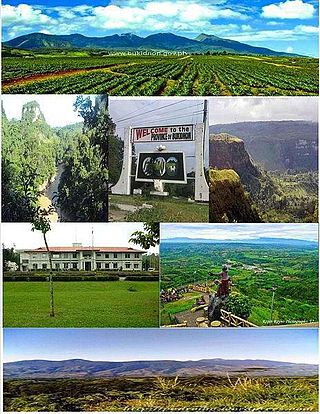
Bukidnon, officially the Province of Bukidnon, is a landlocked province in the Philippines located in the Northern Mindanao region. Its capital is the city of Malaybalay. The province borders, clockwise from the north, Misamis Oriental, Agusan del Sur, Davao del Norte, Cotabato, Lanao del Sur, and Lanao del Norte. According to the 2020 census, the province is inhabited by 1,541,308 residents. The province is composed of 2 component cities and 20 municipalities. It is the third largest province in the country in terms of total area of jurisdiction behind Palawan and Isabela respectively.

Malaybalay, officially the City of Malaybalay, is a 1st class component city and capital of the province of Bukidnon, Philippines. According to the 2020 census, it has a population of 190,712 people.
Kalamansig, officially the Municipality of Kalamansig, is a 1st class municipality in the province of Sultan Kudarat, Philippines. According to the 2020 census, it has a population of 50,900 people.

Arakan, officially the Municipality of Arakan is a 1st class municipality in the province of Cotabato, Philippines. According to the 2020 census, it has a population of 50,558 people.

Kabacan officially the Municipality of Kabacan, is a 1st class municipality in the province of Cotabato, Philippines. According to the 2020 census, it has a population of 77,164 people.

Valencia, officially the City of Valencia, is a 2nd class component city in the province of Bukidnon, Philippines. According to the 2020 census, it has a population of 216,546 people.
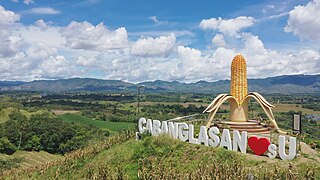
Cabanglasan, officially the Municipality of Cabanglasan, is a 3rd class municipality in the province of Bukidnon, Philippines. According to the 2020 census, it has a population of 36,286 people.

Dangcagan, officially the Municipality of Dangcagan, is a 3rd class municipality in the province of Bukidnon, Philippines. According to the 2020 census, it has a population of 26,076 people.

Kibawe, officially the Municipality of Kibawe, is a 2nd class municipality in the province of Bukidnon, Philippines. According to the 2020 census, it has a population of 41,897 people.

Kitaotao, officially the Municipality of Kitaotao, is a 1st class municipality in the province of Bukidnon, Philippines. According to the 2020 census, it has a population of 53,796 people.

San Fernando, officially the Municipality of San Fernando, is a 1st class municipality in the province of Bukidnon, Philippines. According to the 2020 census, it has a population of 63,045 people.

Sumilao, officially the Municipality of Sumilao, is a 4th class municipality in the province of Bukidnon, Philippines. According to the 2020 census, it has a population of 29,531 people.
Casisang is the most populous of the 46 barangays of Malaybalay. It is the seat of government of the City of Malaybalay since the City Hall is located here. Situated in the South Highway District of Malaybalay, Casisang borders on the north with the Poblacion barangays of Barangay 11, Barangay 7, and Barangay 9, on the east with Can-ayan, on the south with San Jose, Magsaysay, and Mapayag, and on the West by Imbayao and Kalasungay. According to 2015 census Casisang has a population of 25,696 people.

Can-ayan is a rural barangay in the North Highway District of Malaybalay City, Bukidnon, Philippines. According to the 2015 census, Can-ayan has a population of 5,870 people.
Saint Peter is a rural barangay in the Upper Pulangi District of Malaybalay City, Bukidnon. It is situated 63 kilometres northeast of the city proper, on the east bank of the Pulangi River. According to the 2015 census, it has a population of 2,324 people.
Busdi is a rural barangay of the Upper Pulangi District of Malaybalay, Bukidnon, Philippines. According to the 2015 census, it has a population of 2,377 people. It is bounded to the north by Barangay Bulonay of Impasug-ong, to the east by the Municipality of La Paz, Agusan del Sur, to the south by Saint Peter and Kulaman, and to the west by Kibalabag and Manalog.
Caburacanan is a rural barangay of the Upper Pulangi District in Malaybalay City, Bukidnon, Philippines. According to the 2015 census, it has a population of 1,150 people, making it the least populated village in Upper Pulangi. It is bounded to the north by Kulaman, to the east by Saint Peter and Zamboanguita, to the south by Mapulo, and to the west by Can-ayan and Kibalabag. The western part of the village is mountainous with vast old-growth forests and the east is a valley along the Pulangi River, where the village proper is found. The population is mostly Higaunen. It had two sitios under its jurisdiction which are now abandoned: Sambukan, a hamlet to the north; and Talahidan, on the west. Caburacanan has one elementary school administered by the Department of Education, Division of Malaybalay City
Zamboanguita is a rural barangay in the Upper Pulangi District of the city of Malaybalay, Philippines. According to the 2015 census, it has a population of 1,667 people. It is bounded to the north by Saint Peter separated by the Tigpaniki Creek, to the east by the Municipality of La Paz, Agusan del Sur separated by the Pantaron Range, to the south by Indalasa separated by the Pagpag Creek and Mount Mintakdaw, and to the west by Caburacanan and Mapulo separated by the Pulangi River. Zamboanguita sits on a fertile valley between the Pulangi River and the Pantaron Range where most of its area is classified as forestland. It is primarily agricultural with a flourishing commercial activity. It has two sitios: Malilong and Kinuaw. Zamboanguita has one public elementary school, administered by the Department of Education, Division of Malaybalay
Mapulo is an urbanizing barangay in the Upper Pulangi District of Malaybalay, Bukidnon, Philippines. According to the 2015 census, it has a population of 1,260 people.

Malaybalay, the capital of Bukidnon, is subdivided into 46 barangays. The Philippine Standard Geographic Code classifies 15 barangays as urban and 31 rural; however, the City of Malaybalay classifies 18 barangays as urban and 28 rural. These barangays are grouped into five administrative districts, namely Basakan, North Highway, Poblacion, South Highway, and Upper Pulangi.
